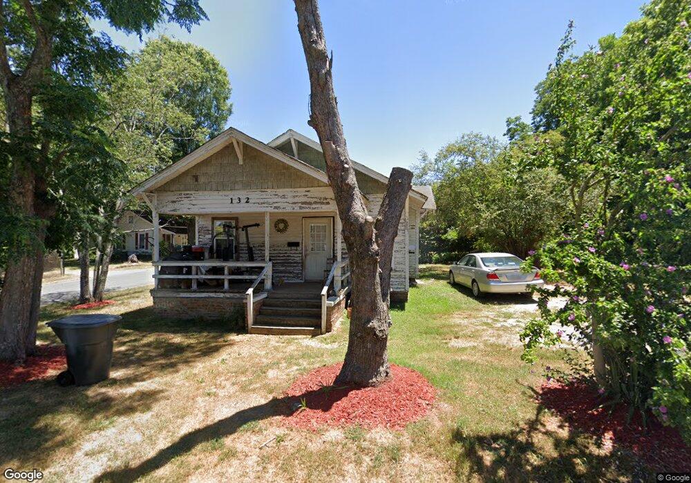
132 Memorial St Asheboro, NC 27203
Estimated Value: $61,000 - $107,000
--
Bed
1
Bath
840
Sq Ft
$107/Sq Ft
Est. Value
About This Home
This home is located at 132 Memorial St, Asheboro, NC 27203 and is currently estimated at $89,994, approximately $107 per square foot. 132 Memorial St is a home located in Randolph County with nearby schools including Donna L. Loflin Elementary School, South Asheboro Middle School, and Asheboro High School.
Ownership History
Date
Name
Owned For
Owner Type
Purchase Details
Closed on
Sep 29, 2006
Sold by
Braswell Gerald E
Bought by
Martinez Lucina Quezadas
Current Estimated Value
Home Financials for this Owner
Home Financials are based on the most recent Mortgage that was taken out on this home.
Original Mortgage
$42,900
Interest Rate
10%
Mortgage Type
Purchase Money Mortgage
Purchase Details
Closed on
Feb 22, 2006
Sold by
Barnes Dorothy B
Bought by
Braswell Gerald E
Purchase Details
Closed on
Aug 16, 1996
Bought by
Martinez Lucina Quezadas
Create a Home Valuation Report for This Property
The Home Valuation Report is an in-depth analysis detailing your home's value as well as a comparison with similar homes in the area
Home Values in the Area
Average Home Value in this Area
Purchase History
| Date | Buyer | Sale Price | Title Company |
|---|---|---|---|
| Martinez Lucina Quezadas | $42,500 | None Available | |
| Braswell Gerald E | $37,000 | None Available | |
| Martinez Lucina Quezadas | $26,000 | -- |
Source: Public Records
Mortgage History
| Date | Status | Borrower | Loan Amount |
|---|---|---|---|
| Previous Owner | Martinez Lucina Quezadas | $42,900 |
Source: Public Records
Tax History Compared to Growth
Tax History
| Year | Tax Paid | Tax Assessment Tax Assessment Total Assessment is a certain percentage of the fair market value that is determined by local assessors to be the total taxable value of land and additions on the property. | Land | Improvement |
|---|---|---|---|---|
| 2025 | $765 | $57,720 | $25,320 | $32,400 |
| 2024 | $765 | $57,720 | $25,320 | $32,400 |
| 2023 | $765 | $57,720 | $25,320 | $32,400 |
| 2022 | $680 | $47,180 | $25,040 | $22,140 |
| 2021 | $680 | $47,180 | $25,040 | $22,140 |
| 2020 | $680 | $47,180 | $25,040 | $22,140 |
| 2019 | $680 | $47,180 | $25,040 | $22,140 |
| 2018 | $621 | $42,300 | $25,040 | $17,260 |
| 2016 | $621 | $42,298 | $25,040 | $17,258 |
| 2015 | $622 | $42,298 | $25,040 | $17,258 |
| 2014 | -- | $42,298 | $25,040 | $17,258 |
Source: Public Records
Map
Nearby Homes
- 711 Sunset Ave Unit E
- 612 Sunset Ave Unit 6
- 612 Sunset Ave Unit 5
- 830 Sunset Ave
- 135 Dixon St
- 314 Pershing St
- 923 Arnold St
- 401 Uwharrie St
- 645 W Wainman Ave
- 435 Peachtree St
- 631 W Kivett St
- 617 Uwharrie St Unit N
- 627 Lee St
- 806 Windermere Ct
- 330 W Presnell St Unit 37
- 828 Windermere Ct
- 330 13 W Presnell St
- TBD Oakland Ave
- 255 Liberty St
- 211 Armfield Ave