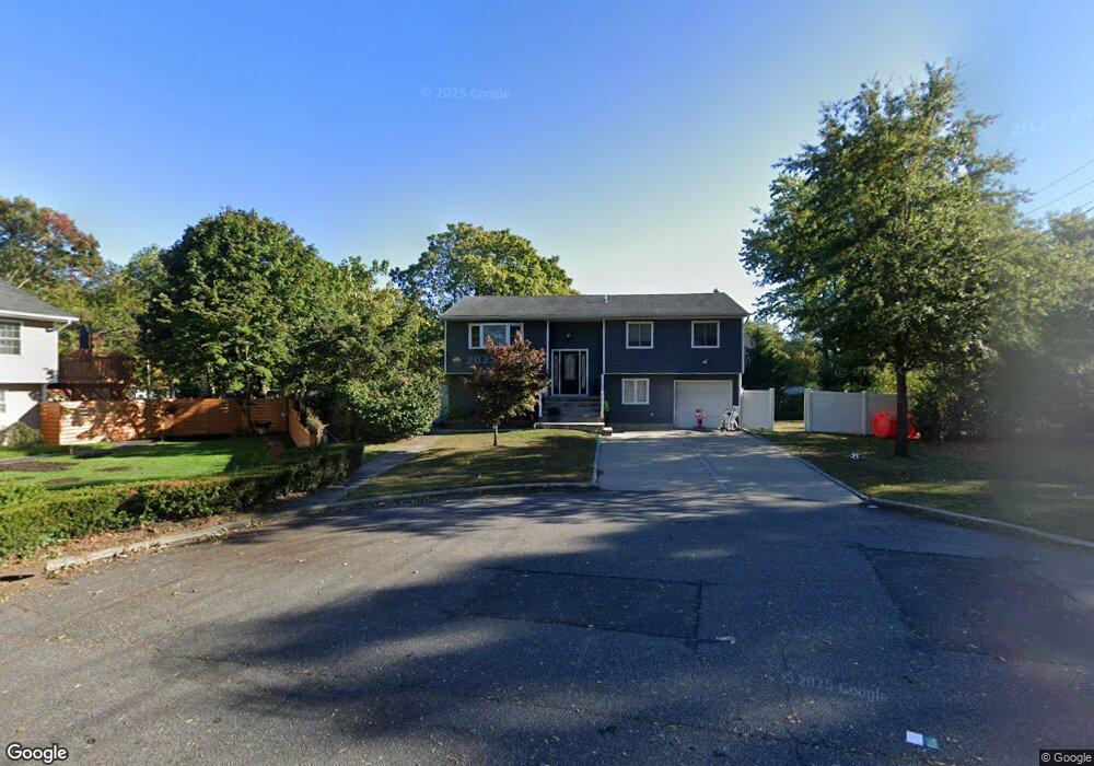
132 Oray St Brentwood, NY 11717
Estimated Value: $586,000 - $644,000
5
Beds
2
Baths
--
Sq Ft
10,454
Sq Ft Lot
About This Home
This home is located at 132 Oray St, Brentwood, NY 11717 and is currently estimated at $623,870. 132 Oray St is a home located in Suffolk County with nearby schools including MDQ Academy.
Ownership History
Date
Name
Owned For
Owner Type
Purchase Details
Closed on
Jan 13, 2015
Sold by
Srmof Ii Reo 2013 1 Trust
Bought by
Tang Steven
Current Estimated Value
Purchase Details
Closed on
Jan 25, 2014
Sold by
Davis Joyce and Davis Johnnie Mae
Bought by
Srmof Ii Reo 2013 1 Trust
Purchase Details
Closed on
Nov 7, 2000
Sold by
Rouse Edward J and Rouse Michele
Bought by
Davis Joyce and Davis Johnnie Mae
Home Financials for this Owner
Home Financials are based on the most recent Mortgage that was taken out on this home.
Original Mortgage
$200,307
Interest Rate
7.78%
Mortgage Type
FHA
Create a Home Valuation Report for This Property
The Home Valuation Report is an in-depth analysis detailing your home's value as well as a comparison with similar homes in the area
Home Values in the Area
Average Home Value in this Area
Purchase History
| Date | Buyer | Sale Price | Title Company |
|---|---|---|---|
| Tang Steven | $198,000 | Fidelity National Title | |
| Srmof Ii Reo 2013 1 Trust | $165,000 | -- | |
| Davis Joyce | $202,000 | -- |
Source: Public Records
Mortgage History
| Date | Status | Borrower | Loan Amount |
|---|---|---|---|
| Previous Owner | Davis Joyce | $200,307 |
Source: Public Records
Tax History Compared to Growth
Tax History
| Year | Tax Paid | Tax Assessment Tax Assessment Total Assessment is a certain percentage of the fair market value that is determined by local assessors to be the total taxable value of land and additions on the property. | Land | Improvement |
|---|---|---|---|---|
| 2024 | -- | $35,800 | $5,100 | $30,700 |
| 2023 | -- | $35,800 | $5,100 | $30,700 |
| 2022 | $8,079 | $35,800 | $5,100 | $30,700 |
| 2021 | $8,079 | $35,800 | $5,100 | $30,700 |
| 2020 | $7,288 | $35,800 | $5,100 | $30,700 |
| 2019 | $8,079 | $0 | $0 | $0 |
| 2018 | -- | $35,800 | $5,100 | $30,700 |
| 2017 | $8,209 | $35,800 | $5,100 | $30,700 |
| 2016 | $8,110 | $35,800 | $5,100 | $30,700 |
| 2015 | -- | $35,800 | $5,100 | $30,700 |
| 2014 | -- | $35,800 | $5,100 | $30,700 |
Source: Public Records
Map
Nearby Homes
- 219 Front Ave
- 587 Freeman Ave
- 186 Westwood Dr
- 153 Cocoanut St
- 12 Kaymac St
- 141 Sheridan St
- 86 Riddle St
- 754 Broadway
- 205 Hilltop Dr
- 167 Gibson Ave
- 1350 Islip Ave
- 365 American Blvd Unit 365-1
- 158 Broadway
- 1290 Islip Ave
- 154 Charter Oaks Ave
- 10 Ehler St
- 35 Gray St
- 71 Banana St
- 102 Branch Ave
- 136 Tabor St