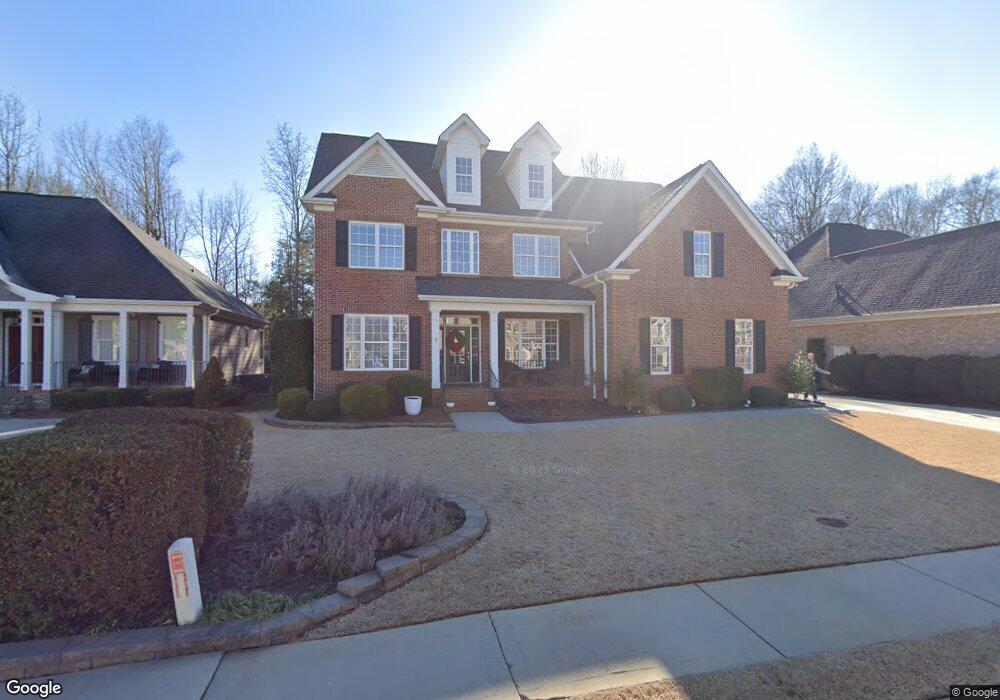
134 Holland Trace Cir Simpsonville, SC 29681
Estimated Value: $593,228 - $697,000
3
Beds
3
Baths
3,049
Sq Ft
$212/Sq Ft
Est. Value
About This Home
This home is located at 134 Holland Trace Cir, Simpsonville, SC 29681 and is currently estimated at $645,057, approximately $211 per square foot. 134 Holland Trace Cir is a home located in Greenville County with nearby schools including Bethel Elementary School, Hillcrest Middle School, and Mauldin High School.
Ownership History
Date
Name
Owned For
Owner Type
Purchase Details
Closed on
Jun 22, 2007
Sold by
Enslin Builders Inc
Bought by
Larkins Ii Lark O
Current Estimated Value
Home Financials for this Owner
Home Financials are based on the most recent Mortgage that was taken out on this home.
Original Mortgage
$210,000
Outstanding Balance
$127,870
Interest Rate
6.1%
Mortgage Type
Purchase Money Mortgage
Estimated Equity
$517,187
Purchase Details
Closed on
Apr 5, 2007
Sold by
Putnam & Holland Associates Llc
Bought by
Enslin Builders Inc
Create a Home Valuation Report for This Property
The Home Valuation Report is an in-depth analysis detailing your home's value as well as a comparison with similar homes in the area
Home Values in the Area
Average Home Value in this Area
Purchase History
| Date | Buyer | Sale Price | Title Company |
|---|---|---|---|
| Larkins Ii Lark O | $375,000 | None Available | |
| Enslin Builders Inc | $80,000 | None Available |
Source: Public Records
Mortgage History
| Date | Status | Borrower | Loan Amount |
|---|---|---|---|
| Open | Larkins Ii Lark O | $210,000 |
Source: Public Records
Tax History Compared to Growth
Tax History
| Year | Tax Paid | Tax Assessment Tax Assessment Total Assessment is a certain percentage of the fair market value that is determined by local assessors to be the total taxable value of land and additions on the property. | Land | Improvement |
|---|---|---|---|---|
| 2024 | $3,010 | $15,740 | $2,400 | $13,340 |
| 2023 | $3,010 | $15,740 | $2,400 | $13,340 |
| 2022 | $2,938 | $15,740 | $2,400 | $13,340 |
| 2021 | $2,939 | $15,740 | $2,400 | $13,340 |
| 2020 | $3,052 | $15,510 | $2,200 | $13,310 |
| 2019 | $3,054 | $15,510 | $2,200 | $13,310 |
| 2018 | $2,975 | $15,510 | $2,200 | $13,310 |
| 2017 | $2,975 | $15,510 | $2,200 | $13,310 |
| 2016 | $2,879 | $387,660 | $55,000 | $332,660 |
| 2015 | $2,879 | $387,660 | $55,000 | $332,660 |
| 2014 | $2,629 | $358,740 | $48,000 | $310,740 |
Source: Public Records
Map
Nearby Homes
- 1 Lone Oak Ave
- 104 Shea Ct
- 6 Paranor Dr
- 907 Highway 14
- 00 Holland Rd
- 600 Daisy Hill Ln
- 401 Holland Rd
- 403 Holland Rd
- 9 Hollywoods Ln Unit B
- 120 Lavender Hill Ct Unit Site 6
- 108 Acacia Dr
- 213 Harts Ln
- 42 Carriage Run Dr
- 106 Clingmore Ct
- 202 Mornington Ct
- 2 Pembark Ln
- 201 Long Point Way
- 240 Applehill Way
- 301 Blant Ct
- 105 Martindale Dr
- 136 Holland Trace Cir
- 132 Holland Trace Cir
- 138 Holland Trace Cir
- 129 Holland Trace Cir
- 130 Holland Trace Cir
- 131 Holland Trace Cir
- 127 Holland Trace Cir
- 133 Holland Trace Cir
- 140 Holland Trace Cir
- 125 Holland Trace Cir
- 128 Holland Trace Cir
- 135 Holland Trace Cir
- 7 Lone Oak Ave
- 5 Lone Oak Ave
- 9 Lone Oak Ave
- 3 Lone Oak Ave
- 31 Harts Ln
- 11 Lone Oak Ave
- 124 Holland Trace Cir
- 207 Benjamine Perry Ct