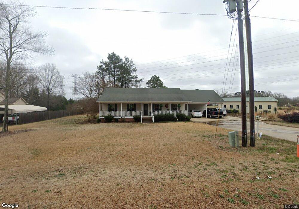
1350 Allison Cir Rock Hill, SC 29732
Estimated Value: $302,702 - $355,000
3
Beds
2
Baths
1,569
Sq Ft
$210/Sq Ft
Est. Value
About This Home
This home is located at 1350 Allison Cir, Rock Hill, SC 29732 and is currently estimated at $328,851, approximately $209 per square foot. 1350 Allison Cir is a home located in York County with nearby schools including Mount Gallant Elementary School, Dutchman Creek Middle School, and Northwestern High School.
Ownership History
Date
Name
Owned For
Owner Type
Purchase Details
Closed on
Aug 30, 2019
Sold by
Gainey Maudine
Bought by
Gainey Joshua Redmond
Current Estimated Value
Purchase Details
Closed on
Oct 26, 2015
Sold by
Gainey Maudine
Bought by
Mcclellan David L and Mcclellan Katherine R
Home Financials for this Owner
Home Financials are based on the most recent Mortgage that was taken out on this home.
Original Mortgage
$146,301
Outstanding Balance
$115,462
Interest Rate
3.89%
Mortgage Type
FHA
Estimated Equity
$213,389
Purchase Details
Closed on
Mar 15, 2002
Sold by
Gainey Maudine
Bought by
Louthan Robert A
Create a Home Valuation Report for This Property
The Home Valuation Report is an in-depth analysis detailing your home's value as well as a comparison with similar homes in the area
Home Values in the Area
Average Home Value in this Area
Purchase History
| Date | Buyer | Sale Price | Title Company |
|---|---|---|---|
| Gainey Joshua Redmond | -- | None Available | |
| Mcclellan David L | $149,000 | -- | |
| Louthan Robert A | $23,000 | -- |
Source: Public Records
Mortgage History
| Date | Status | Borrower | Loan Amount |
|---|---|---|---|
| Open | Mcclellan David L | $146,301 |
Source: Public Records
Tax History Compared to Growth
Tax History
| Year | Tax Paid | Tax Assessment Tax Assessment Total Assessment is a certain percentage of the fair market value that is determined by local assessors to be the total taxable value of land and additions on the property. | Land | Improvement |
|---|---|---|---|---|
| 2024 | $48 | $131 | $131 | $0 |
| 2023 | $48 | $131 | $131 | $0 |
| 2022 | $45 | $131 | $131 | $0 |
| 2021 | -- | $131 | $131 | $0 |
| 2020 | $840 | $2,502 | $0 | $0 |
| 2019 | $34 | $2,502 | $0 | $0 |
| 2018 | $33 | $97 | $0 | $0 |
| 2017 | $31 | $97 | $0 | $0 |
| 2016 | $31 | $97 | $0 | $0 |
| 2014 | $2,716 | $7,960 | $1,000 | $6,960 |
| 2013 | $2,716 | $9,190 | $1,000 | $8,190 |
Source: Public Records
Map
Nearby Homes
- 5022 Drake Pond Ln
- 4073 Canvas Ave
- 423 Shallowford Dr
- 1230 Bowater Rd
- 239 Heatherland Dr
- 1015 Hands Mill Hwy
- 5380 Woodside Dr
- 5381 Woodside Dr
- 479 Shallowford Dr
- 440 Shallowford Dr
- 1767 Hands Mill Hwy
- 3059 Oxtail Ct
- 3029 Oxtail Ct
- 1592 Covenant Place
- 933 Kingswood Dr
- 364 Paraham Rd S
- 2060 Covered Bridge Ct
- 314 Challis Ct
- 2035 Covered Bridge Ct
- 305 White Water Dr
- 1358 Allison Cir
- 1162 Allison Cir
- 1380 Allison Cir
- 1362 Hands Mill Hwy
- 1311 Allison Cir
- 1398 Allison Cir
- 1352 Hands Mill Hwy
- 1384 Hands Mill Hwy
- 1307 Hands Mill Hwy
- 5688 Mt Gallant Rd
- 1250 Hands Mill Hwy
- 1363 Hands Mill Hwy
- 1412 Hands Mill Hwy
- 1393 Allison Cir
- 2010 Mallard Creek Dr
- 2010 Mallard Creek Dr Unit 1
- 1421 Allison Cir
- 2014 Mallard Creek Dr
- 2018 Mallard Creek Dr
- 2022 Mallard Creek Dr