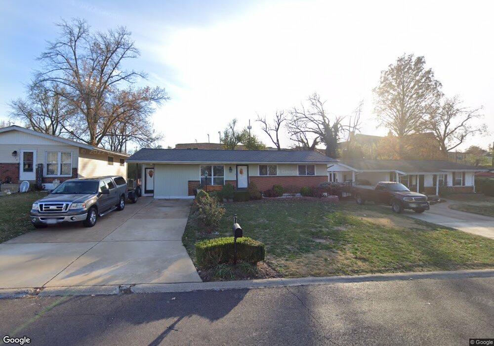
138 Burncoate Dr Saint Louis, MO 63129
Estimated Value: $220,967 - $270,000
2
Beds
1
Bath
1,128
Sq Ft
$220/Sq Ft
Est. Value
About This Home
This home is located at 138 Burncoate Dr, Saint Louis, MO 63129 and is currently estimated at $247,992, approximately $219 per square foot. 138 Burncoate Dr is a home located in St. Louis County with nearby schools including Wohlwend Elementary School, Bernard Middle School, and Oakville Senior High School.
Ownership History
Date
Name
Owned For
Owner Type
Purchase Details
Closed on
Apr 15, 2009
Sold by
Casalone Matthew A and Casalone Beatriz V
Bought by
Navarro Ruben
Current Estimated Value
Purchase Details
Closed on
Mar 6, 2009
Sold by
Segelle Mark William and Segelle Judith A
Bought by
Casalone Matthew A and Casalone Beatriz
Purchase Details
Closed on
Jul 28, 1989
Sold by
Troske Dale F and Troske Dale Frederick
Bought by
Troske Dale Frederick and Segelle Mark William
Create a Home Valuation Report for This Property
The Home Valuation Report is an in-depth analysis detailing your home's value as well as a comparison with similar homes in the area
Home Values in the Area
Average Home Value in this Area
Purchase History
| Date | Buyer | Sale Price | Title Company |
|---|---|---|---|
| Navarro Ruben | $80,703 | Kts | |
| Casalone Matthew A | -- | Keeven Title Services | |
| Troske Dale Frederick | -- | None Available |
Source: Public Records
Mortgage History
| Date | Status | Borrower | Loan Amount |
|---|---|---|---|
| Closed | Navarro Ruben | $0 |
Source: Public Records
Tax History Compared to Growth
Tax History
| Year | Tax Paid | Tax Assessment Tax Assessment Total Assessment is a certain percentage of the fair market value that is determined by local assessors to be the total taxable value of land and additions on the property. | Land | Improvement |
|---|---|---|---|---|
| 2025 | $2,097 | $38,160 | $20,810 | $17,350 |
| 2024 | $2,097 | $31,030 | $9,540 | $21,490 |
| 2023 | $2,070 | $31,030 | $9,540 | $21,490 |
| 2022 | $1,788 | $26,890 | $11,270 | $15,620 |
| 2021 | $1,731 | $26,890 | $11,270 | $15,620 |
| 2020 | $1,798 | $26,580 | $11,270 | $15,310 |
| 2019 | $1,793 | $26,580 | $11,270 | $15,310 |
| 2018 | $1,642 | $21,950 | $6,940 | $15,010 |
| 2017 | $1,639 | $21,950 | $6,940 | $15,010 |
| 2016 | $1,555 | $19,960 | $5,230 | $14,730 |
| 2015 | $1,429 | $19,960 | $5,230 | $14,730 |
| 2014 | $1,269 | $17,500 | $4,120 | $13,380 |
Source: Public Records
Map
Nearby Homes
- 4555 Burncoate Dr
- 141 Stallard Ln
- 4460 Telegraph Rd
- 2 Freeman Dr
- 236 Tapestry Dr
- 5228 Kings Park Dr
- 223 Freeman Dr
- 5405 Edelweis Ln
- 4322 Martyridge Dr
- 200 Rouen Dr
- 2408 Whitshire Dr
- 2552 Coppergate Square Dr
- 2675 Victron Dr
- 5126 Firelight Ct
- 5501 Dober Ln
- 337 Saddle Back Dr
- 4130 Saddle Back Ct
- 2711 Windford Ct
- 517 Aqua Ridge Dr
- 144 Martigney Dr
- 142 Burncoate Dr
- 134 Burncoate Dr
- 146 Burncoate Dr
- 130 Burncoate Dr
- 150 Burncoate Dr
- 4550 Burncoate Dr
- 139 Burncoate Dr
- 143 Burncoate Dr
- 154 Burncoate Dr
- 4551 Burncoate Dr
- 158 Burncoate Dr
- 4525 Wolfgang Dr
- 4547 Burncoate Dr
- 4540 Burncoate Dr
- 155 Burncoate Dr
- 136 Stallard Ln
- 4521 Wolfgang Dr
- 4543 Burncoate Dr
- 4539 Thicket Dr
- 140 Stallard Ln