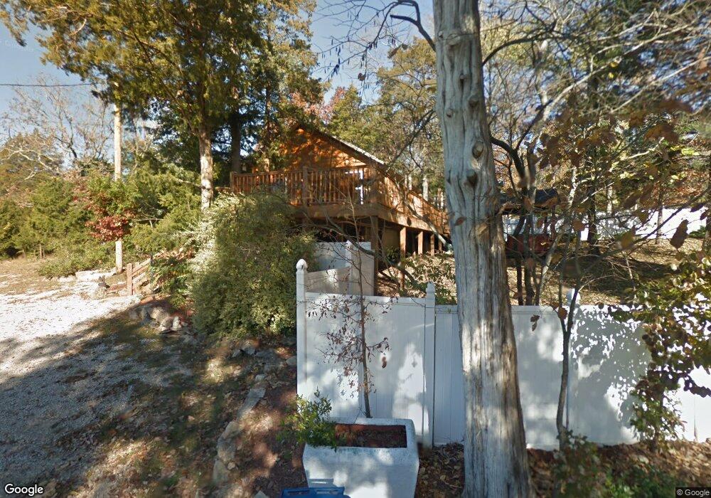
139 Root Rd Hollister, MO 65672
Estimated Value: $199,134 - $248,000
--
Bed
--
Bath
1,056
Sq Ft
$214/Sq Ft
Est. Value
About This Home
This home is located at 139 Root Rd, Hollister, MO 65672 and is currently estimated at $225,534, approximately $213 per square foot. 139 Root Rd is a home located in Taney County with nearby schools including Hollister Elementary School, Hollister Middle School, and Hollister High School.
Ownership History
Date
Name
Owned For
Owner Type
Purchase Details
Closed on
Oct 13, 2020
Sold by
Delagardelle Tyler Alan and Delagardelle Brittany
Bought by
Richardson Kenneth L
Current Estimated Value
Home Financials for this Owner
Home Financials are based on the most recent Mortgage that was taken out on this home.
Original Mortgage
$151,515
Outstanding Balance
$134,765
Interest Rate
2.9%
Mortgage Type
New Conventional
Estimated Equity
$90,769
Purchase Details
Closed on
Aug 22, 2008
Sold by
Ckpt Llc
Bought by
Rizzo Brian J and Rizzo Debra A
Create a Home Valuation Report for This Property
The Home Valuation Report is an in-depth analysis detailing your home's value as well as a comparison with similar homes in the area
Home Values in the Area
Average Home Value in this Area
Purchase History
| Date | Buyer | Sale Price | Title Company |
|---|---|---|---|
| Richardson Kenneth L | -- | None Available | |
| Rizzo Brian J | -- | -- |
Source: Public Records
Mortgage History
| Date | Status | Borrower | Loan Amount |
|---|---|---|---|
| Open | Richardson Kenneth L | $151,515 |
Source: Public Records
Tax History Compared to Growth
Tax History
| Year | Tax Paid | Tax Assessment Tax Assessment Total Assessment is a certain percentage of the fair market value that is determined by local assessors to be the total taxable value of land and additions on the property. | Land | Improvement |
|---|---|---|---|---|
| 2025 | $941 | $15,370 | -- | -- |
| 2023 | $941 | $16,960 | $0 | $0 |
| 2022 | $945 | $17,290 | $0 | $0 |
| 2021 | $913 | $17,290 | $0 | $0 |
| 2019 | $827 | $15,320 | $0 | $0 |
| 2018 | $712 | $12,950 | $0 | $0 |
| 2017 | $705 | $12,950 | $0 | $0 |
| 2016 | $697 | $12,950 | $0 | $0 |
| 2015 | $693 | $12,950 | $0 | $0 |
| 2014 | $667 | $12,390 | $0 | $0 |
Source: Public Records
Map
Nearby Homes
- 215 Sagers Ln
- 181 Sagers Ln
- 229 Sagers Ln
- 235 Sagers Ln
- 243 Sagers Ln
- 142 Oakwood Estates Ct
- 169 Michaels Dr
- 313 Laurel St
- 182 Gumdrop Dr
- 331 Evergreen Ave
- 152 Rea St
- 265 Lakeview Dr
- 24 & 25 Lakeview Dr
- 000 Lakeview Dr
- 177 Foley St
- 221 Foley St
- 2229 S Business 65
- 000 Bus Hwy 65
- Lot 1 Cedar Landing Subdivision
- 3152 Maple St
- 139 Root St
- 120 Root St
- 160 Root Street (Aka 885 Bb Hwy)
- 885 State Highway Bb
- 181 Root St
- 120 Root Rd
- 119 Root Rd
- 160 Root St
- 202 Root 1-4
- 202 Root St
- 202 Root Rd
- 202 Root Rd
- 820 State Highway Bb
- 820 State Highway Bb
- 616 Evergreen Ave
- 266 Hawthorne St
- 753 State Highway Bb
- 222 Hawthorne St
- 304 Hawthorne St
- 214 Root Rd