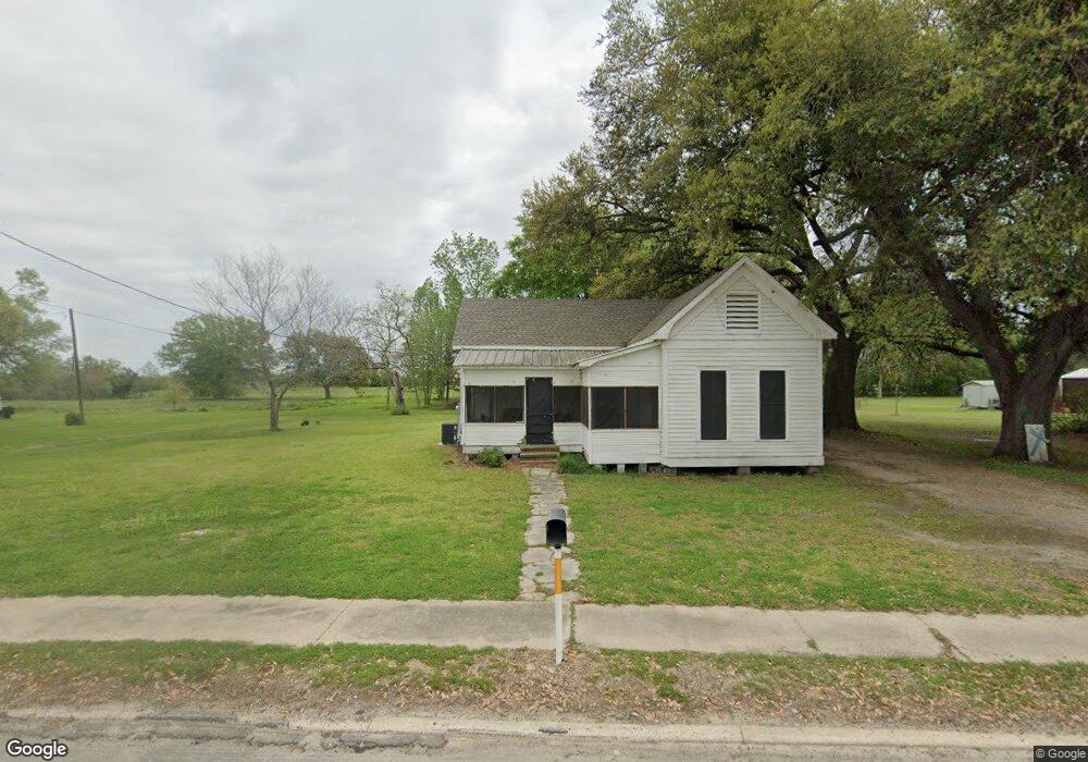
1407 Dupont Dr Orange, TX 77630
East Orange NeighborhoodEstimated Value: $105,000 - $127,142
--
Bed
--
Bath
1,415
Sq Ft
$80/Sq Ft
Est. Value
About This Home
This home is located at 1407 Dupont Dr, Orange, TX 77630 and is currently estimated at $113,714, approximately $80 per square foot. 1407 Dupont Dr is a home located in Orange County with nearby schools including West Orange-Stark Elementary School, West Orange-Stark Middle School, and West Orange-Stark High School.
Ownership History
Date
Name
Owned For
Owner Type
Purchase Details
Closed on
May 19, 2014
Sold by
Plant Larry Clint and Estate Of Larry James Plant
Bought by
Burch William T
Current Estimated Value
Purchase Details
Closed on
Oct 25, 2013
Sold by
Earl Hazel and Earl Wesley F
Bought by
Plant Larry
Purchase Details
Closed on
Oct 15, 2013
Sold by
Denmon Donny
Bought by
Burch William T
Purchase Details
Closed on
Sep 5, 2007
Sold by
Coulter Lee Ann
Bought by
Burch William T
Create a Home Valuation Report for This Property
The Home Valuation Report is an in-depth analysis detailing your home's value as well as a comparison with similar homes in the area
Home Values in the Area
Average Home Value in this Area
Purchase History
| Date | Buyer | Sale Price | Title Company |
|---|---|---|---|
| Burch William T | -- | None Available | |
| Plant Larry | -- | None Available | |
| Burch William T | -- | -- | |
| Burch William T | -- | -- |
Source: Public Records
Tax History Compared to Growth
Tax History
| Year | Tax Paid | Tax Assessment Tax Assessment Total Assessment is a certain percentage of the fair market value that is determined by local assessors to be the total taxable value of land and additions on the property. | Land | Improvement |
|---|---|---|---|---|
| 2024 | $1,856 | $108,821 | $37,991 | $70,830 |
| 2023 | $1,672 | $97,351 | $37,991 | $59,360 |
| 2022 | $1,424 | $73,301 | $25,331 | $47,970 |
| 2021 | $1,350 | $67,661 | $25,331 | $42,330 |
| 2020 | $1,229 | $61,331 | $25,331 | $36,000 |
| 2019 | $1,359 | $64,521 | $25,331 | $39,190 |
| 2018 | $1,306 | $62,632 | $25,331 | $37,301 |
| 2017 | $1,306 | $62,632 | $25,331 | $37,301 |
| 2016 | $1,427 | $68,343 | $25,331 | $43,012 |
| 2015 | $1,106 | $68,343 | $25,331 | $43,012 |
| 2014 | $1,106 | $53,002 | $10,490 | $42,512 |
Source: Public Records
Map
Nearby Homes
- 1601 Georgia Ave
- 1008 Dupont Dr
- 607 Dupont Dr
- 710 Levingston St
- 906 W Scott St
- 802 Border St
- 602 Border St
- 1621 Western Ave
- 803 Chester St
- 412 Market St
- 1100 & 1106 Flint St
- 2308 Travis St
- 2404 Smith St
- 701 Sherrill St
- 811 Flint St
- 2112 Houston St Unit 2114
- 2112 & 2114 Houston
- 2120 Houston St
- 1212 Irving St
- 208 College St
- 1409 Dupont Dr
- 1401 Dupont Dr
- 1406 Dupont Dr
- 1404 Dupont Dr
- 1311 Dupont Dr
- 110 Morris St
- 1312 Dupont Dr
- 1411 Dupont Dr
- 111 Nash St
- 1308 Dupont Dr
- 1306 Dupont Dr
- 1405 Louisiana St
- 1400 Texas Ave
- 1404 Texas Ave
- 1403 Louisiana St
- 106 Rhode Island St
- 201 Rhode Island St
- 1506 Dupont Dr
- 104 Nash St
- 203 Nash St