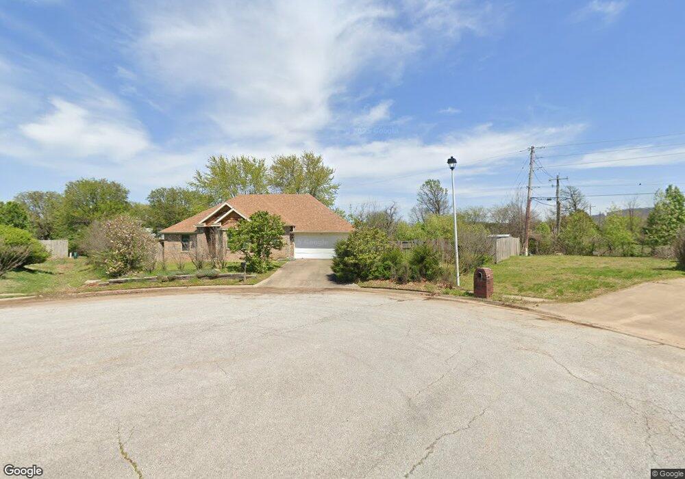
142 Whitney Ln Farmington, AR 72730
Estimated Value: $291,000 - $318,000
--
Bed
2
Baths
1,608
Sq Ft
$188/Sq Ft
Est. Value
About This Home
This home is located at 142 Whitney Ln, Farmington, AR 72730 and is currently estimated at $301,980, approximately $187 per square foot. 142 Whitney Ln is a home located in Washington County with nearby schools including Randall G. Lynch Middle School, Bob Folsom Elementary School, and Farmington Jr. High.
Ownership History
Date
Name
Owned For
Owner Type
Purchase Details
Closed on
Oct 26, 2004
Sold by
Mcdonald Ryan J and Mcdonald Elizabeth A
Bought by
Bartlett Cristy S
Current Estimated Value
Home Financials for this Owner
Home Financials are based on the most recent Mortgage that was taken out on this home.
Original Mortgage
$125,850
Outstanding Balance
$61,700
Interest Rate
5.62%
Mortgage Type
Purchase Money Mortgage
Estimated Equity
$240,280
Purchase Details
Closed on
Aug 20, 2003
Sold by
Flora L Wayne and Allen Aaron J
Bought by
Mcdonald Ryan J and Mcdonald Elizabeth A
Purchase Details
Closed on
Aug 19, 2003
Sold by
Flora Brenda
Bought by
Flora L Wayne and Allen Aaron J
Purchase Details
Closed on
Jul 30, 1997
Bought by
Flora Wayne and Flora Brenda
Purchase Details
Closed on
Jun 16, 1997
Bought by
Allen Aaron J
Purchase Details
Closed on
Jul 25, 1996
Bought by
Lossing John D
Create a Home Valuation Report for This Property
The Home Valuation Report is an in-depth analysis detailing your home's value as well as a comparison with similar homes in the area
Home Values in the Area
Average Home Value in this Area
Purchase History
| Date | Buyer | Sale Price | Title Company |
|---|---|---|---|
| Bartlett Cristy S | $133,000 | Lenders | |
| Mcdonald Ryan J | -- | Lenders Title Company | |
| Flora L Wayne | $115,000 | -- | |
| Flora Wayne | $9,000 | -- | |
| Allen Aaron J | -- | -- | |
| Lossing John D | -- | -- |
Source: Public Records
Mortgage History
| Date | Status | Borrower | Loan Amount |
|---|---|---|---|
| Open | Bartlett Cristy S | $125,850 |
Source: Public Records
Tax History Compared to Growth
Tax History
| Year | Tax Paid | Tax Assessment Tax Assessment Total Assessment is a certain percentage of the fair market value that is determined by local assessors to be the total taxable value of land and additions on the property. | Land | Improvement |
|---|---|---|---|---|
| 2025 | $1,173 | $51,680 | $9,000 | $42,680 |
| 2024 | $1,213 | $51,680 | $9,000 | $42,680 |
| 2023 | $1,280 | $51,680 | $9,000 | $42,680 |
| 2022 | $1,249 | $30,290 | $6,000 | $24,290 |
| 2021 | $1,208 | $30,290 | $6,000 | $24,290 |
| 2020 | $1,136 | $30,290 | $6,000 | $24,290 |
| 2019 | $1,069 | $26,700 | $5,400 | $21,300 |
| 2018 | $1,094 | $26,700 | $5,400 | $21,300 |
| 2017 | $1,081 | $26,700 | $5,400 | $21,300 |
| 2016 | $1,081 | $26,700 | $5,400 | $21,300 |
| 2015 | $1,081 | $26,700 | $5,400 | $21,300 |
| 2014 | $1,107 | $27,190 | $5,400 | $21,790 |
Source: Public Records
Map
Nearby Homes
- 271 Greenfield Ave
- 237 Briarhill Dr
- 311 S Sundown Dr
- 285 Briarhill Dr
- 201 Countryside Dr
- 93 Old Depot Rd
- 275 S Nightfall Ave
- 303 S Coventry Ave
- Rye 1903 Plan at The Grove at Engles Mill
- Ouachita 1669 Plan at The Grove at Engles Mill
- Cache 1788 Plan at The Grove at Engles Mill
- Degray 1757 Plan at The Grove at Engles Mill
- Stella 1848 Plan at The Grove at Engles Mill
- Millwood 1862 Plan at The Grove at Engles Mill
- Magnolia 1556 Plan at The Grove at Engles Mill
- Eureka 1536 Plan at The Grove at Engles Mill
- Springs 1445 Plan at The Grove at Engles Mill
- Piper 2064 Plan at The Grove at Engles Mill
- Oak 1463 Plan at The Grove at Engles Mill
- Daisy 2147 Plan at The Grove at Engles Mill
- 150 Whitney Ln
- 143, 145 Rainsong Dr Unit 143, 145
- 143 Rainsong Dr
- 145 Rainsong Dr
- 141 Whitney Ln
- 143 Rainsong Dr
- 151 Rainsong Dr
- 156 Whitney Ln
- 0 Rainsong St
- 149 Whitney Ln
- 157 & 159 Rainsong St
- 157 Rainsong Dr
- 155 Whitney Ln
- 162 Whitney Ln
- 144 Rainsong Dr
- 112 Signature Dr
- 161 Whitney Ln
- 163 Rainsong Dr
- 254 Greenfield Ave
- 170 Whitney Ln