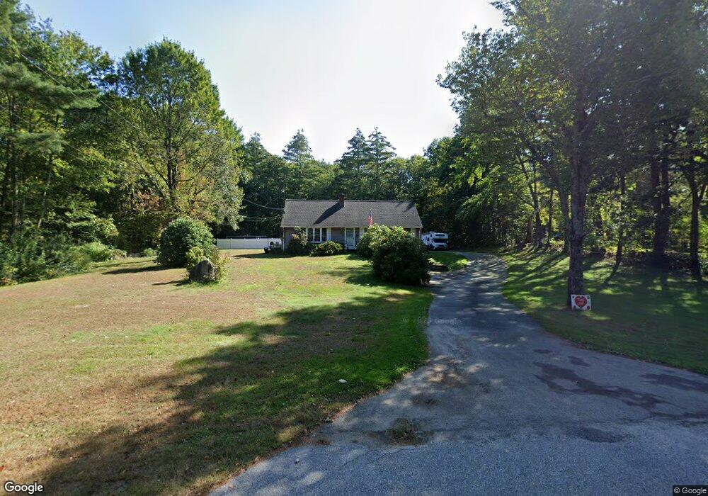
143 Monson Rd Stafford Springs, CT 06076
Stafford NeighborhoodEstimated Value: $322,000 - $410,000
3
Beds
2
Baths
1,907
Sq Ft
$196/Sq Ft
Est. Value
About This Home
This home is located at 143 Monson Rd, Stafford Springs, CT 06076 and is currently estimated at $373,064, approximately $195 per square foot. 143 Monson Rd is a home located in Tolland County with nearby schools including Stafford Elementary School, Stafford Middle School, and Stafford High School.
Ownership History
Date
Name
Owned For
Owner Type
Purchase Details
Closed on
Jul 22, 2024
Sold by
Hnatuik Donna D
Bought by
Bennett Herbert H and Bennett Bruce
Current Estimated Value
Purchase Details
Closed on
Apr 25, 2019
Sold by
Bennett Herbert H and Bennett Dorothy E
Bought by
Bennett Herbert H and Bennett Bruce
Purchase Details
Closed on
Jan 16, 1986
Bought by
Bennett Herbert H and Bennett Dorothy E
Create a Home Valuation Report for This Property
The Home Valuation Report is an in-depth analysis detailing your home's value as well as a comparison with similar homes in the area
Home Values in the Area
Average Home Value in this Area
Purchase History
| Date | Buyer | Sale Price | Title Company |
|---|---|---|---|
| Bennett Herbert H | -- | None Available | |
| Bennett Herbert H | -- | None Available | |
| Bennett Herbert H | -- | -- | |
| Bennett Herbert H | -- | -- | |
| Bennett Herbert H | -- | -- |
Source: Public Records
Mortgage History
| Date | Status | Borrower | Loan Amount |
|---|---|---|---|
| Previous Owner | Bennett Herbert H | $59,000 |
Source: Public Records
Tax History Compared to Growth
Tax History
| Year | Tax Paid | Tax Assessment Tax Assessment Total Assessment is a certain percentage of the fair market value that is determined by local assessors to be the total taxable value of land and additions on the property. | Land | Improvement |
|---|---|---|---|---|
| 2025 | $9,673 | $170,520 | $31,010 | $139,510 |
| 2024 | $6,580 | $170,520 | $31,010 | $139,510 |
| 2023 | $6,268 | $170,520 | $31,010 | $139,510 |
| 2022 | $6,101 | $170,520 | $31,010 | $139,510 |
| 2021 | $5,956 | $170,520 | $31,010 | $139,510 |
| 2020 | $5,788 | $165,690 | $34,440 | $131,250 |
| 2019 | $5,753 | $164,710 | $34,440 | $130,270 |
| 2018 | $5,643 | $164,710 | $34,440 | $130,270 |
| 2017 | $5,589 | $164,710 | $34,440 | $130,270 |
| 2016 | $5,519 | $164,710 | $34,440 | $130,270 |
| 2015 | $5,519 | $147,350 | $34,440 | $112,910 |
| 2014 | $4,867 | $147,350 | $34,440 | $112,910 |
Source: Public Records
Map
Nearby Homes
- 10 Laurel Ln
- 15 Deepwood Dr
- 81 Monson Rd
- 8 Gale Rd
- 97 Orcuttville Rd
- 2 Pinewood Ln
- 200 Orcuttville Rd
- 4 Pinewood Ln
- 12 Hillcrest Dr
- 4 Leonard Rd
- 14 Valley View Dr
- 105 Leonard Rd
- 19 Potter Rd
- 0 Rockledge Rd Unit 24131563
- 192 Leonard Rd
- 80 W Stafford Rd
- 115 W Stafford Rd
- 201 Diamond Ledge Rd
- 336 East St
- 0 Stony Ln