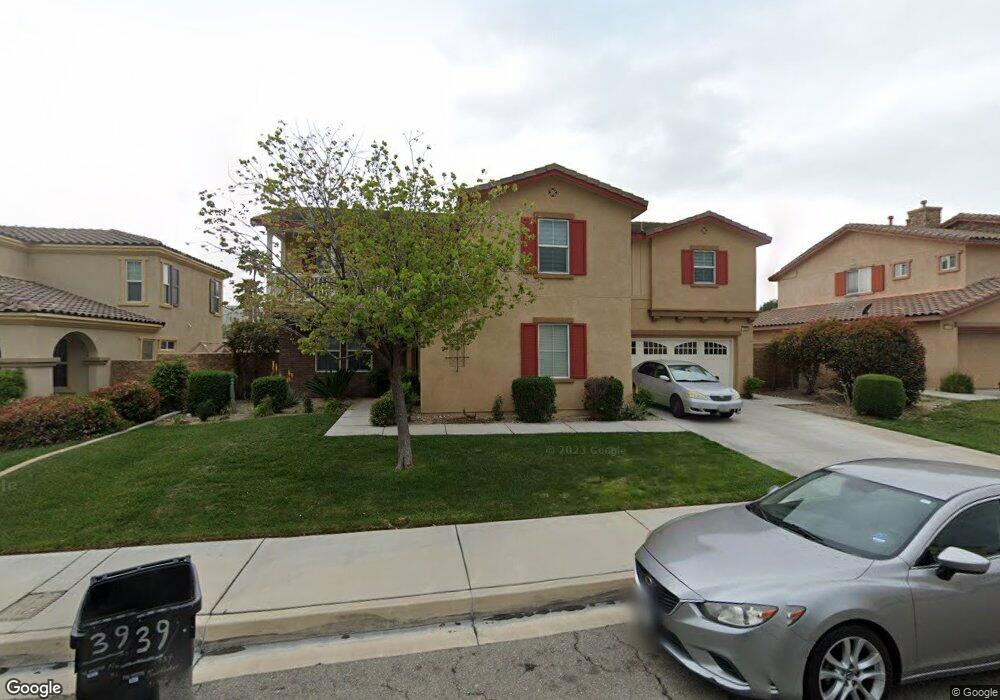
1439 Northstar St San Bernardino, CA 92407
University NeighborhoodEstimated Value: $670,204 - $844,000
3
Beds
3
Baths
3,039
Sq Ft
$251/Sq Ft
Est. Value
About This Home
This home is located at 1439 Northstar St, San Bernardino, CA 92407 and is currently estimated at $761,551, approximately $250 per square foot. 1439 Northstar St is a home located in San Bernardino County with nearby schools including Bob Holcomb Elementary School, Shandin Hills Middle School, and Cajon High School.
Ownership History
Date
Name
Owned For
Owner Type
Purchase Details
Closed on
May 20, 2011
Sold by
Owb Reo Llc
Bought by
Ma Chunyan
Current Estimated Value
Home Financials for this Owner
Home Financials are based on the most recent Mortgage that was taken out on this home.
Original Mortgage
$204,800
Outstanding Balance
$140,143
Interest Rate
4.55%
Mortgage Type
New Conventional
Estimated Equity
$621,408
Purchase Details
Closed on
Nov 15, 2010
Sold by
Zaccaglin Victor
Bought by
Owb Reo Llc
Purchase Details
Closed on
Nov 29, 2007
Sold by
Northpark 19 Llc
Bought by
Zaccaglin Victor
Purchase Details
Closed on
Nov 28, 2007
Sold by
Zaccaglin Hannah
Bought by
Zaccaglin Victor
Create a Home Valuation Report for This Property
The Home Valuation Report is an in-depth analysis detailing your home's value as well as a comparison with similar homes in the area
Home Values in the Area
Average Home Value in this Area
Purchase History
| Date | Buyer | Sale Price | Title Company |
|---|---|---|---|
| Ma Chunyan | $256,000 | Lsi Title Company Ca | |
| Owb Reo Llc | $425,876 | None Available | |
| Zaccaglin Victor | -- | First American Title Company | |
| Zaccaglin Victor | -- | First American Title Company |
Source: Public Records
Mortgage History
| Date | Status | Borrower | Loan Amount |
|---|---|---|---|
| Open | Ma Chunyan | $204,800 |
Source: Public Records
Tax History Compared to Growth
Tax History
| Year | Tax Paid | Tax Assessment Tax Assessment Total Assessment is a certain percentage of the fair market value that is determined by local assessors to be the total taxable value of land and additions on the property. | Land | Improvement |
|---|---|---|---|---|
| 2025 | $4,556 | $324,941 | $96,465 | $228,476 |
| 2024 | $4,556 | $318,570 | $94,574 | $223,996 |
| 2023 | $4,438 | $312,324 | $92,720 | $219,604 |
| 2022 | $4,430 | $306,200 | $90,902 | $215,298 |
| 2021 | $4,422 | $300,196 | $89,120 | $211,076 |
| 2020 | $4,422 | $297,118 | $88,206 | $208,912 |
| 2019 | $4,295 | $291,292 | $86,476 | $204,816 |
| 2018 | $4,171 | $285,580 | $84,780 | $200,800 |
| 2017 | $4,035 | $279,981 | $83,118 | $196,863 |
| 2016 | $3,793 | $274,491 | $81,488 | $193,003 |
| 2015 | $3,649 | $270,368 | $80,264 | $190,104 |
| 2014 | $3,756 | $265,072 | $78,692 | $186,380 |
Source: Public Records
Map
Nearby Homes
- 5205 N Mammoth Dr
- 1380 W 48th St Unit 30
- 5294 Sundance Dr
- 4834 Alta Dr
- 1503 Indian Trail
- 4905 Village Green Way
- 1559 Wild Pony Path
- 10 Kendall Dr
- 5548 Westwind Dr
- 4729 Windsor Ct
- 1548 Teton St
- 4231 N 4th Ave
- 1511 Yardley St
- 4281 Mountain Dr
- 1594 Morgan Rd
- 1265 Kendall Dr Unit 723
- 1265 Kendall Dr
- 1265 Kendall Dr Unit 811
- 1265 Kendall Dr Unit 6I5
- 1066 W 49th St
- 1431 Northstar St
- 1445 Northstar St
- 1444 Keystone Dr
- 1438 Keystone Dr
- 1448 Keystone Dr
- 1451 Northstar St
- 1425 Northstar St
- 1434 Keystone Dr
- 1454 Keystone Dr
- 1442 Northstar St
- 1428 Keystone Dr
- 1419 Northstar St
- 1459 Northstar St
- 5331 Brighton Ct
- 1458 Keystone Dr
- 1455 Keystone Dr
- 1424 Keystone Dr
- 1464 Keystone Dr
- 5235 Mammoth Dr
- 1465 Northstar St