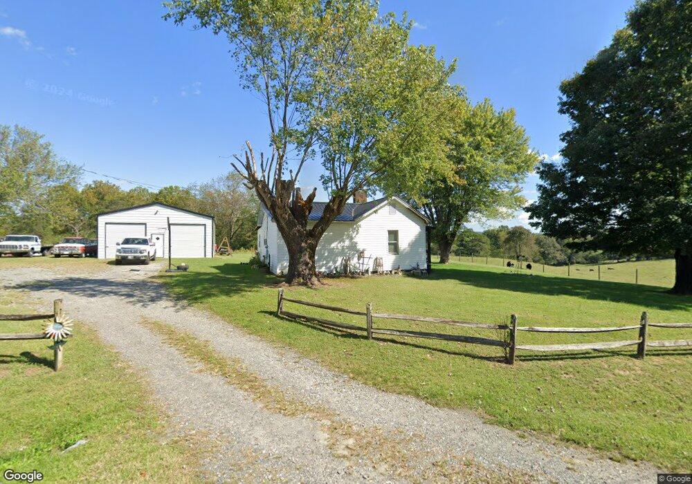
144 Old Ridge Rd Mount Airy, NC 27030
Estimated Value: $140,787 - $211,000
1
Bed
1
Bath
976
Sq Ft
$176/Sq Ft
Est. Value
About This Home
This home is located at 144 Old Ridge Rd, Mount Airy, NC 27030 and is currently estimated at $171,947, approximately $176 per square foot. 144 Old Ridge Rd is a home with nearby schools including Flat Rock Elementary School, Meadowview Magnet Middle School, and North Surry High School.
Ownership History
Date
Name
Owned For
Owner Type
Purchase Details
Closed on
Jun 29, 2010
Sold by
Gig Properties Llc
Bought by
Pell Danny L and Pell Misty
Current Estimated Value
Home Financials for this Owner
Home Financials are based on the most recent Mortgage that was taken out on this home.
Original Mortgage
$64,000
Outstanding Balance
$42,597
Interest Rate
4.83%
Mortgage Type
FHA
Estimated Equity
$129,350
Purchase Details
Closed on
Oct 1, 2003
Purchase Details
Closed on
Jun 1, 2002
Purchase Details
Closed on
Jun 1, 1998
Purchase Details
Closed on
May 1, 1991
Purchase Details
Closed on
Dec 1, 1990
Create a Home Valuation Report for This Property
The Home Valuation Report is an in-depth analysis detailing your home's value as well as a comparison with similar homes in the area
Home Values in the Area
Average Home Value in this Area
Purchase History
| Date | Buyer | Sale Price | Title Company |
|---|---|---|---|
| Pell Danny L | $80,000 | None Available | |
| -- | -- | -- | |
| -- | -- | -- | |
| -- | $63,500 | -- | |
| -- | -- | -- | |
| -- | $15,000 | -- |
Source: Public Records
Mortgage History
| Date | Status | Borrower | Loan Amount |
|---|---|---|---|
| Open | Pell Danny L | $64,000 |
Source: Public Records
Tax History Compared to Growth
Tax History
| Year | Tax Paid | Tax Assessment Tax Assessment Total Assessment is a certain percentage of the fair market value that is determined by local assessors to be the total taxable value of land and additions on the property. | Land | Improvement |
|---|---|---|---|---|
| 2025 | $814 | $123,190 | $56,500 | $66,690 |
| 2024 | $613 | $84,950 | $56,500 | $28,450 |
| 2023 | $604 | $84,950 | $56,500 | $28,450 |
| 2022 | $604 | $84,950 | $56,500 | $28,450 |
| 2021 | $613 | $84,950 | $56,500 | $28,450 |
| 2020 | $584 | $77,290 | $51,370 | $25,920 |
| 2019 | $581 | $77,290 | $0 | $0 |
| 2018 | $572 | $77,290 | $0 | $0 |
| 2017 | $568 | $77,290 | $0 | $0 |
| 2016 | $562 | $77,290 | $0 | $0 |
| 2013 | -- | $67,260 | $0 | $0 |
Source: Public Records
Map
Nearby Homes
- 663 Mcbride Rd
- 335 Badgett Ave
- 845 Linville Rd
- 1769 Inglebrook Trail
- 00 Jackson Rd Unit 8.64 Ac
- 00 Paynetown Rd
- 2638 Riverside Dr
- 0 Jackson Rd
- 1694 Woodbury Ln
- 280 Burke Rd
- 1816 Gwyn St
- 234 Hylton St
- 607 Riverside Dr
- 1709 N Main St
- 1709 N Main St Unit A-1
- 344 Linville Rd
- 316 Linville Rd
- 2029 N Main St
- 105 Grace St
- 0 Woodruff St