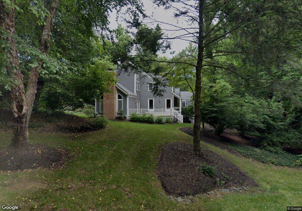
1444 Watchers Ln Crownsville, MD 21032
Estimated Value: $826,029 - $1,159,000
--
Bed
3
Baths
3,100
Sq Ft
$325/Sq Ft
Est. Value
About This Home
This home is located at 1444 Watchers Ln, Crownsville, MD 21032 and is currently estimated at $1,007,257, approximately $324 per square foot. 1444 Watchers Ln is a home located in Anne Arundel County with nearby schools including South Shore Elementary School, Old Mill High School, and Indian Creek School.
Ownership History
Date
Name
Owned For
Owner Type
Purchase Details
Closed on
Jun 19, 2006
Sold by
Lindsay Mark S
Bought by
Lindsay Mark S and Lindsay Nancy R
Current Estimated Value
Purchase Details
Closed on
Jun 15, 2006
Sold by
Lindsay Mark S
Bought by
Lindsay Mark S and Lindsay Nancy R
Purchase Details
Closed on
Feb 22, 1993
Sold by
Hantgan Richard S
Bought by
Lindsay Mark S
Home Financials for this Owner
Home Financials are based on the most recent Mortgage that was taken out on this home.
Original Mortgage
$379,516
Interest Rate
7.65%
Create a Home Valuation Report for This Property
The Home Valuation Report is an in-depth analysis detailing your home's value as well as a comparison with similar homes in the area
Home Values in the Area
Average Home Value in this Area
Purchase History
| Date | Buyer | Sale Price | Title Company |
|---|---|---|---|
| Lindsay Mark S | -- | -- | |
| Lindsay Mark S | -- | -- | |
| Lindsay Mark S | $93,500 | -- |
Source: Public Records
Mortgage History
| Date | Status | Borrower | Loan Amount |
|---|---|---|---|
| Previous Owner | Lindsay Mark S | $379,516 |
Source: Public Records
Tax History Compared to Growth
Tax History
| Year | Tax Paid | Tax Assessment Tax Assessment Total Assessment is a certain percentage of the fair market value that is determined by local assessors to be the total taxable value of land and additions on the property. | Land | Improvement |
|---|---|---|---|---|
| 2025 | $7,413 | $686,900 | $189,800 | $497,100 |
| 2024 | $7,413 | $660,300 | $0 | $0 |
| 2023 | $7,214 | $633,700 | $0 | $0 |
| 2022 | $6,344 | $607,100 | $214,800 | $392,300 |
| 2021 | $13,253 | $597,333 | $0 | $0 |
| 2020 | $6,473 | $587,567 | $0 | $0 |
| 2019 | $6,364 | $577,800 | $244,800 | $333,000 |
| 2018 | $5,833 | $575,267 | $0 | $0 |
| 2017 | $5,999 | $572,733 | $0 | $0 |
| 2016 | -- | $570,200 | $0 | $0 |
| 2015 | -- | $570,200 | $0 | $0 |
| 2014 | -- | $570,200 | $0 | $0 |
Source: Public Records
Map
Nearby Homes
- 0 Generals Hwy
- 1603 Upton Scott Way
- 1101 Opaca Ct
- 1496 River Rd
- 1634 Old Generals Hwy
- 1404 Cotton Ct
- 0 Yew Trail Unit MDAA2121932
- 975 Diggs Rd
- 938 Diggs Rd
- 0 Old Herald Harbor Rd Unit MDAA2109542
- 0 Old Herald Harbor Rd Unit MDAA2115958
- 902 Hine Trail
- 1458 Wilderness Ridge Trail
- 478 Mountain Rd
- 0 Herald Harbor Rd Unit MDAA2123892
- 1080 Generals Hwy
- 1002 Covington Way
- 872 Redwood Trail
- 359 Hall Rd
- 934 Chesterfield Rd
- 1442 Wild Cranberry Ct
- 1435 Wild Cranberry Ct
- 1331 Sweet Pea Path
- 1333 Sweet Pea Path
- 1446 Watchers Ln
- 1434 Wild Cranberry Ct
- 1431 Generals Hwy
- 1448 Watchers Ln
- 1432 Wild Cranberry Ct
- 1336 Sweet Pea Path
- 1527 Wild Cranberry Dr
- 1437 Generals Hwy
- 1338 Sweet Pea Path
- 1430 Wild Cranberry Ct
- 1339 Sweet Pea Path
- 1340 Sweet Pea Path
- 40 Private R W
- 1450 Watchers Ln
- 1526 Wild Cranberry Dr
- 1528 Wild Cranberry Dr