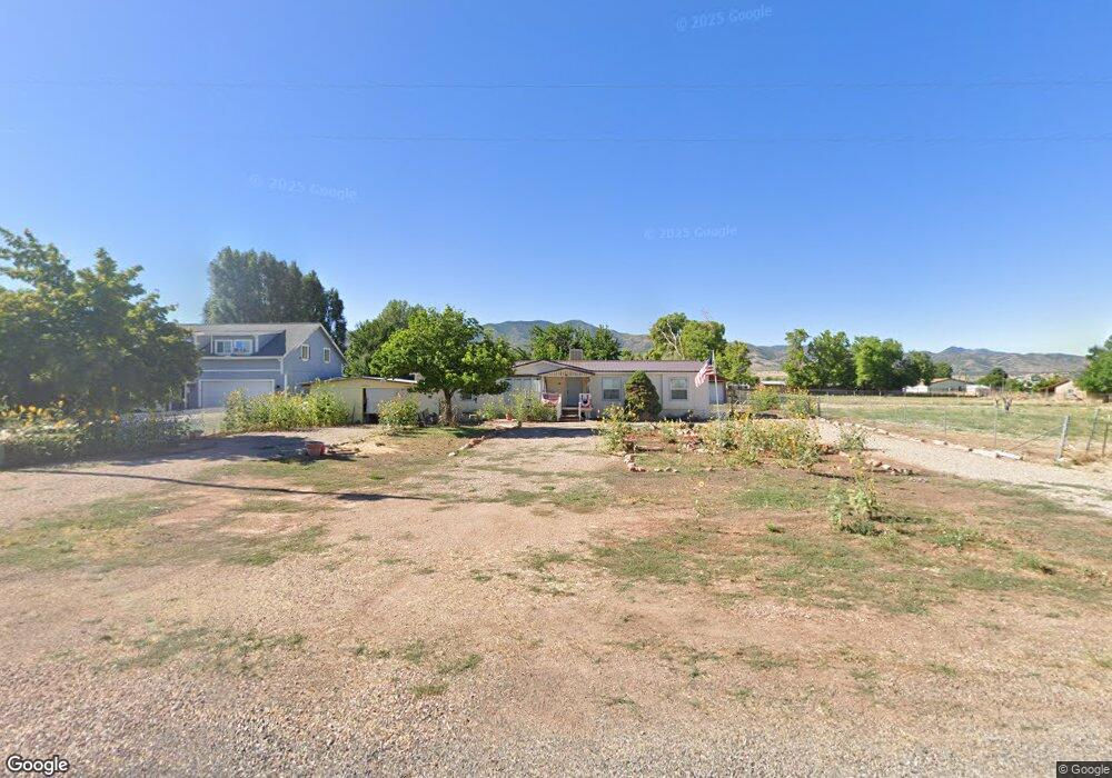
145 W 100 St N Kanosh, UT 84637
Estimated Value: $228,000 - $538,000
--
Bed
--
Bath
--
Sq Ft
0.39
Acres
About This Home
This home is located at 145 W 100 St N, Kanosh, UT 84637 and is currently estimated at $349,087. 145 W 100 St N is a home.
Ownership History
Date
Name
Owned For
Owner Type
Purchase Details
Closed on
Jan 11, 2024
Sold by
Mitchell Doyal K
Bought by
Mitchell Family Trust and Mitchell
Current Estimated Value
Purchase Details
Closed on
Oct 9, 2018
Sold by
Hardy Carol A
Bought by
Hardy Carol and Hardy Family Trust
Purchase Details
Closed on
Sep 24, 2018
Sold by
Hardy Carol A
Bought by
Hardy Carol and Hardy Family Trust
Purchase Details
Closed on
Dec 1, 2016
Sold by
Fannie Mae
Bought by
Hardy Carol A
Create a Home Valuation Report for This Property
The Home Valuation Report is an in-depth analysis detailing your home's value as well as a comparison with similar homes in the area
Home Values in the Area
Average Home Value in this Area
Purchase History
| Date | Buyer | Sale Price | Title Company |
|---|---|---|---|
| Mitchell Family Trust | -- | None Listed On Document | |
| Hardy Carol | -- | None Available | |
| Hardy Carol | -- | None Available | |
| Hardy Carol A | -- | Lawyers Title |
Source: Public Records
Tax History Compared to Growth
Tax History
| Year | Tax Paid | Tax Assessment Tax Assessment Total Assessment is a certain percentage of the fair market value that is determined by local assessors to be the total taxable value of land and additions on the property. | Land | Improvement |
|---|---|---|---|---|
| 2025 | $216 | $119,492 | $29,150 | $90,342 |
| 2024 | $216 | $94,934 | $15,642 | $79,292 |
| 2023 | $22 | $94,934 | $15,642 | $79,292 |
| 2022 | $0 | $75,394 | $12,514 | $62,880 |
| 2021 | $0 | $63,717 | $10,881 | $52,836 |
| 2020 | $611 | $55,863 | $9,892 | $45,971 |
| 2019 | $551 | $50,678 | $9,075 | $41,603 |
| 2018 | $529 | $49,853 | $8,250 | $41,603 |
| 2017 | $553 | $49,853 | $8,250 | $41,603 |
| 2016 | $563 | $52,919 | $6,188 | $46,731 |
| 2015 | -- | $52,919 | $6,188 | $46,731 |
| 2014 | -- | $52,919 | $6,188 | $46,731 |
| 2013 | -- | $52,919 | $6,188 | $46,731 |
Source: Public Records
Map
Nearby Homes
- 115 W 200 S
- 58 E 300 South St
- 135 E 200 N
- 8610 S Highway 91
- 5098 W Hatton Rd
- Parcel # 8816
- 145 N 200 E
- 60 W Center St
- 50 N 100 Rd E
- 0 Tbd Black Rock Rd Unit LotWP001
- 1565 W Sunflower Ln Unit 3
- 1615 W Sunflower Ln
- 1615 W Sunflower Ln Unit 4
- 1565 W Sunflower Ln
- 2000 N West Frontage I-15
- 1100 S 725 Rd W
- 310 S 500 West Rd
- 190 W 400 St S
- 760 E 700 St S
- 155 E 500 St S