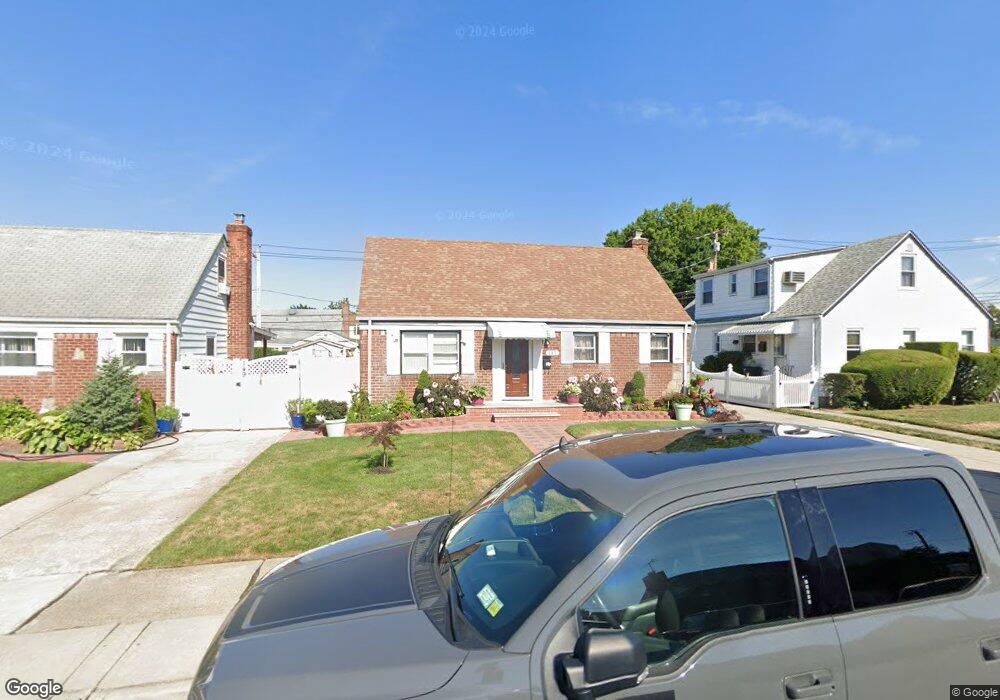
145 Warwick Rd Elmont, NY 11003
Estimated Value: $725,052 - $733,000
--
Bed
2
Baths
1,464
Sq Ft
$498/Sq Ft
Est. Value
About This Home
This home is located at 145 Warwick Rd, Elmont, NY 11003 and is currently estimated at $729,026, approximately $497 per square foot. 145 Warwick Rd is a home located in Nassau County with nearby schools including Martin De Porres School and Bible Baptist Academy.
Ownership History
Date
Name
Owned For
Owner Type
Purchase Details
Closed on
May 12, 2020
Sold by
Mtglq Investors Lp
Bought by
Bonhomme Gerbert and Bonhomme Isemonne
Current Estimated Value
Purchase Details
Closed on
Sep 3, 2019
Sold by
Sklavos Esq Alexander
Bought by
Mtglq Investors Lp
Purchase Details
Closed on
Jan 8, 2004
Sold by
Thompson Terry
Bought by
Ross Carl
Purchase Details
Closed on
Apr 14, 1999
Sold by
Heiser Sadie
Bought by
Thompson Terry and Brown Carolyn
Create a Home Valuation Report for This Property
The Home Valuation Report is an in-depth analysis detailing your home's value as well as a comparison with similar homes in the area
Home Values in the Area
Average Home Value in this Area
Purchase History
| Date | Buyer | Sale Price | Title Company |
|---|---|---|---|
| Bonhomme Gerbert | $355,000 | Fidelity National Title | |
| Bonhomme Gerbert | $355,000 | Fidelity National Title | |
| Mtglq Investors Lp | $598,115 | None Available | |
| Mtglq Investors Lp | $598,115 | None Available | |
| Ross Carl | $325,000 | -- | |
| Ross Carl | $325,000 | -- | |
| Thompson Terry | $117,000 | -- | |
| Thompson Terry | $117,000 | -- |
Source: Public Records
Tax History Compared to Growth
Tax History
| Year | Tax Paid | Tax Assessment Tax Assessment Total Assessment is a certain percentage of the fair market value that is determined by local assessors to be the total taxable value of land and additions on the property. | Land | Improvement |
|---|---|---|---|---|
| 2025 | $11,765 | $455 | $229 | $226 |
| 2024 | $3,794 | $445 | $224 | $221 |
| 2023 | $11,541 | $455 | $229 | $226 |
| 2022 | $11,541 | $455 | $229 | $226 |
| 2021 | $15,786 | $435 | $219 | $216 |
| 2020 | $12,113 | $743 | $550 | $193 |
| 2019 | $4,006 | $743 | $550 | $193 |
| 2018 | $7,757 | $743 | $0 | $0 |
| 2017 | $7,151 | $743 | $550 | $193 |
| 2016 | $10,796 | $743 | $550 | $193 |
| 2015 | $3,386 | $743 | $550 | $193 |
| 2014 | $3,386 | $743 | $550 | $193 |
| 2013 | $3,174 | $743 | $550 | $193 |
Source: Public Records
Map
Nearby Homes
- 10 Cedar St
- 197 Biltmore Ave
- 257 Biltmore Ave
- 98 Locustwood Blvd
- 150 Heathcote Rd
- 266 Biltmore Ave
- 164 Biltmore Ave
- 219 Locustwood Blvd
- 165 Heathcote Rd
- 45 Warwick Rd
- 174 Wellington Rd
- 86-B Gotham Ave
- 80 Biltmore Ave
- 179 Hoffman Ave
- 7 Sterling Rd
- 174 Hoffman Ave
- 86 Gotham Ave
- 2334 Belmont Ave
- 12 Biltmore Ave
- 2092 Hoffman Ave
- 166 109th Ave
- 149 Warwick Rd
- 155 Warwick Rd
- 144 Sterling Rd
- 148 Sterling Rd
- 154 109th Ave
- 178 109th Ave
- 154 Sterling Rd
- 159 Warwick Rd
- 131 Warwick Rd
- 148 Warwick Rd
- 182 109th Ave
- 154 Warwick Rd
- 158 Sterling Rd
- 130 Sterling Rd
- 165 Warwick Rd
- 127 Warwick Rd
- 0 Sterling Rd Unit 3300326
- 158 Warwick Rd
- 179 109th Ave