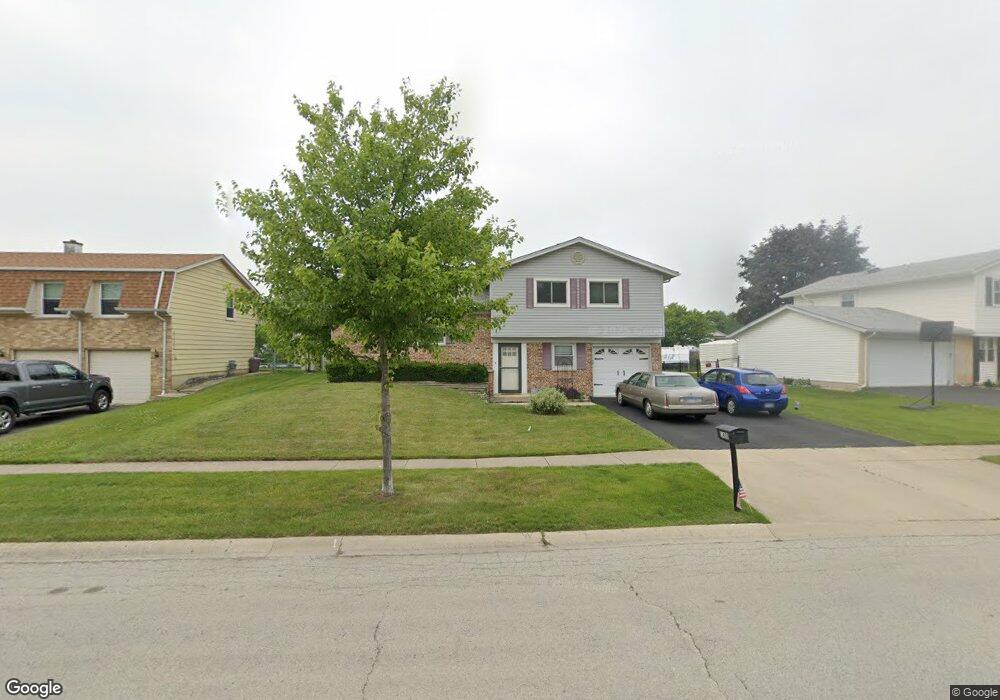
1450 Haise Ln Elk Grove Village, IL 60007
Elk Grove Village West NeighborhoodEstimated Value: $363,000 - $473,000
3
Beds
2
Baths
1,540
Sq Ft
$272/Sq Ft
Est. Value
About This Home
This home is located at 1450 Haise Ln, Elk Grove Village, IL 60007 and is currently estimated at $419,060, approximately $272 per square foot. 1450 Haise Ln is a home located in Cook County with nearby schools including Adlai Stevenson Elementary School, Margaret Mead Junior High School, and J B Conant High School.
Ownership History
Date
Name
Owned For
Owner Type
Purchase Details
Closed on
Apr 21, 2023
Sold by
Tarchala John W
Bought by
Tarchala John W and Piwowarczyk Laura Tarchala
Current Estimated Value
Purchase Details
Closed on
Jun 22, 2010
Sold by
Caiafa Albert D and Caiafa Donna J
Bought by
Tarchala John W
Home Financials for this Owner
Home Financials are based on the most recent Mortgage that was taken out on this home.
Original Mortgage
$167,600
Interest Rate
4.77%
Mortgage Type
New Conventional
Create a Home Valuation Report for This Property
The Home Valuation Report is an in-depth analysis detailing your home's value as well as a comparison with similar homes in the area
Home Values in the Area
Average Home Value in this Area
Purchase History
| Date | Buyer | Sale Price | Title Company |
|---|---|---|---|
| Tarchala John W | -- | None Listed On Document | |
| Tarchala John W | $209,500 | Lakeshore Title Agency |
Source: Public Records
Mortgage History
| Date | Status | Borrower | Loan Amount |
|---|---|---|---|
| Previous Owner | Tarchala John W | $167,600 |
Source: Public Records
Tax History Compared to Growth
Tax History
| Year | Tax Paid | Tax Assessment Tax Assessment Total Assessment is a certain percentage of the fair market value that is determined by local assessors to be the total taxable value of land and additions on the property. | Land | Improvement |
|---|---|---|---|---|
| 2024 | $8,333 | $32,000 | $7,564 | $24,436 |
| 2023 | $8,071 | $32,000 | $7,564 | $24,436 |
| 2022 | $8,071 | $32,000 | $7,564 | $24,436 |
| 2021 | $6,237 | $22,930 | $6,483 | $16,447 |
| 2020 | $6,148 | $22,930 | $6,483 | $16,447 |
| 2019 | $7,342 | $29,727 | $6,483 | $23,244 |
| 2018 | $6,350 | $23,765 | $5,619 | $18,146 |
| 2017 | $6,300 | $23,765 | $5,619 | $18,146 |
| 2016 | $6,130 | $23,765 | $5,619 | $18,146 |
| 2015 | $6,417 | $20,704 | $4,754 | $15,950 |
| 2014 | $6,332 | $20,704 | $4,754 | $15,950 |
| 2013 | $6,170 | $20,704 | $4,754 | $15,950 |
Source: Public Records
Map
Nearby Homes
- 1093 Gloria Dr
- 1453 Armstrong Ln
- 1124 Lovell Ct
- 504 Highland Pkwy
- 725 Bismark Ct
- 1022 Tennessee Ln
- 932 Kentucky Ln
- 947 Wilma Ln
- 1810 Hawk Ln
- 1517 White Trail
- 924 Surrey Dr Unit 1A
- 833 Thornton Ct Unit 2B
- 1845 Maryland Dr
- 826 Thornton Ct Unit 2AL
- 7N606 Hawthorne Ave
- 730 Circle Dr
- 1057 Savoy Ct Unit 221713
- 1224 Knottingham Ct Unit 1A
- 1057 Talbots Ln Unit A
- 620 S Point Dr