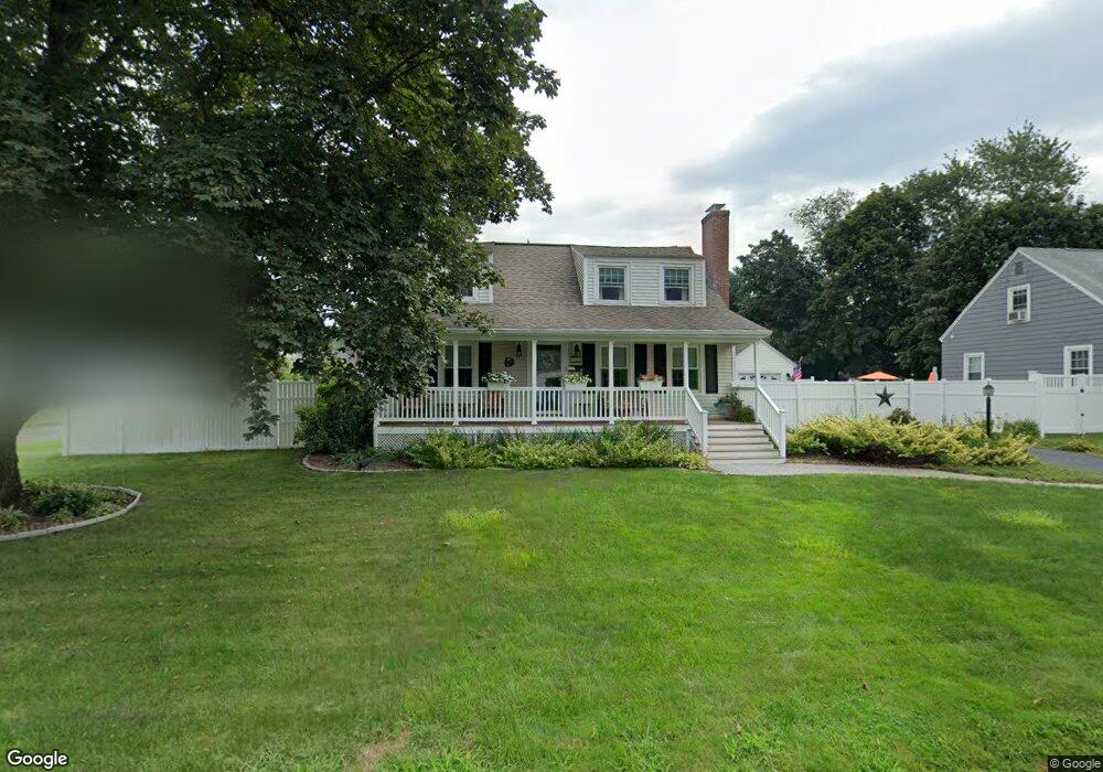
15 Robin Rd Manchester, CT 06042
Bowers NeighborhoodEstimated Value: $317,000 - $337,000
3
Beds
2
Baths
1,495
Sq Ft
$219/Sq Ft
Est. Value
About This Home
This home is located at 15 Robin Rd, Manchester, CT 06042 and is currently estimated at $326,689, approximately $218 per square foot. 15 Robin Rd is a home located in Hartford County with nearby schools including Bowers School, Illing Middle School, and Elisabeth M. Bennet Academy.
Ownership History
Date
Name
Owned For
Owner Type
Purchase Details
Closed on
Oct 25, 1989
Sold by
Bailey Theresa Est
Bought by
Smith Rita E
Current Estimated Value
Home Financials for this Owner
Home Financials are based on the most recent Mortgage that was taken out on this home.
Original Mortgage
$115,200
Interest Rate
9.94%
Mortgage Type
Purchase Money Mortgage
Create a Home Valuation Report for This Property
The Home Valuation Report is an in-depth analysis detailing your home's value as well as a comparison with similar homes in the area
Home Values in the Area
Average Home Value in this Area
Purchase History
| Date | Buyer | Sale Price | Title Company |
|---|---|---|---|
| Smith Rita E | $128,000 | -- |
Source: Public Records
Mortgage History
| Date | Status | Borrower | Loan Amount |
|---|---|---|---|
| Open | Smith Rita E | $129,000 | |
| Closed | Smith Rita E | $90,383 | |
| Closed | Smith Rita E | $100,000 | |
| Closed | Smith Rita E | $115,200 |
Source: Public Records
Tax History Compared to Growth
Tax History
| Year | Tax Paid | Tax Assessment Tax Assessment Total Assessment is a certain percentage of the fair market value that is determined by local assessors to be the total taxable value of land and additions on the property. | Land | Improvement |
|---|---|---|---|---|
| 2025 | $6,220 | $156,200 | $37,500 | $118,700 |
| 2024 | $6,042 | $156,200 | $37,500 | $118,700 |
| 2023 | $5,811 | $156,200 | $37,500 | $118,700 |
| 2022 | $5,697 | $156,200 | $37,500 | $118,700 |
| 2021 | $4,412 | $120,800 | $32,200 | $88,600 |
| 2020 | $4,412 | $120,800 | $32,200 | $88,600 |
| 2019 | $4,412 | $120,800 | $32,200 | $88,600 |
| 2018 | $4,326 | $120,800 | $32,200 | $88,600 |
| 2017 | $4,210 | $120,800 | $32,200 | $88,600 |
| 2016 | $4,206 | $120,700 | $41,200 | $79,500 |
| 2015 | $4,186 | $120,700 | $41,200 | $79,500 |
| 2014 | $4,104 | $120,700 | $41,200 | $79,500 |
Source: Public Records
Map
Nearby Homes
- 210 Green Rd
- 29 Bretton Rd
- 4 Buckingham St
- 70 Weaver Rd
- 85 Henry St
- 120 Green Manor Rd
- 40 Grove St Unit B
- 143 Benton St
- 28 Elizabeth Dr
- 56 Elizabeth Dr
- 213 Oakland St Unit D
- 178 Parker St
- 94 Middle Turnpike E Unit 4
- 41 Delmont St
- 85 Benton St
- 9 Cook St
- 244 Oakland St Unit E
- 244 Oakland St Unit H
- 17 North St
- 50 North St