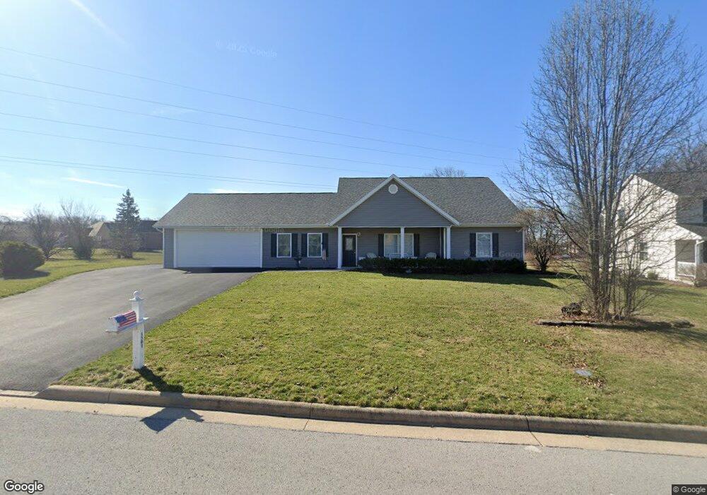
1501 Bay Hill Dr Findlay, OH 45840
Estimated Value: $375,915 - $443,000
3
Beds
3
Baths
1,852
Sq Ft
$224/Sq Ft
Est. Value
About This Home
This home is located at 1501 Bay Hill Dr, Findlay, OH 45840 and is currently estimated at $415,229, approximately $224 per square foot. 1501 Bay Hill Dr is a home located in Hancock County with nearby schools including Liberty-Benton Elementary School, Liberty-Benton Middle School, and Liberty-Benton High School.
Ownership History
Date
Name
Owned For
Owner Type
Purchase Details
Closed on
Jun 7, 2007
Sold by
Mandell Robert M and Mandell Kathy M
Bought by
Conley Chester C and Conley Carol L
Current Estimated Value
Home Financials for this Owner
Home Financials are based on the most recent Mortgage that was taken out on this home.
Original Mortgage
$173,200
Outstanding Balance
$106,038
Interest Rate
6.2%
Mortgage Type
Purchase Money Mortgage
Estimated Equity
$309,191
Create a Home Valuation Report for This Property
The Home Valuation Report is an in-depth analysis detailing your home's value as well as a comparison with similar homes in the area
Home Values in the Area
Average Home Value in this Area
Purchase History
| Date | Buyer | Sale Price | Title Company |
|---|---|---|---|
| Conley Chester C | $216,500 | Mid Am Title Agency |
Source: Public Records
Mortgage History
| Date | Status | Borrower | Loan Amount |
|---|---|---|---|
| Open | Conley Chester C | $173,200 |
Source: Public Records
Tax History Compared to Growth
Tax History
| Year | Tax Paid | Tax Assessment Tax Assessment Total Assessment is a certain percentage of the fair market value that is determined by local assessors to be the total taxable value of land and additions on the property. | Land | Improvement |
|---|---|---|---|---|
| 2024 | $3,410 | $101,530 | $17,200 | $84,330 |
| 2023 | $3,353 | $101,530 | $17,200 | $84,330 |
| 2022 | $3,335 | $101,530 | $17,200 | $84,330 |
| 2021 | $3,252 | $88,620 | $17,200 | $71,420 |
| 2020 | $3,280 | $88,620 | $17,200 | $71,420 |
| 2019 | $3,147 | $88,620 | $17,200 | $71,420 |
| 2018 | $2,597 | $81,510 | $11,470 | $70,040 |
| 2017 | $1,340 | $81,510 | $11,470 | $70,040 |
| 2016 | $2,601 | $81,510 | $11,470 | $70,040 |
| 2015 | $2,670 | $81,640 | $10,380 | $71,260 |
| 2014 | $2,360 | $72,610 | $10,380 | $62,230 |
| 2012 | $2,802 | $72,610 | $10,380 | $62,230 |
Source: Public Records
Map
Nearby Homes
- 1405 Cypress Lake
- 3106 Saddlebrook
- 6535 Silver Lake Dr
- 3018 Gleneagle Dr
- 0 County Road 95 Unit 6097574
- 933 Laurel Ln
- 1310 Muirfield Dr
- 0 County Road 140
- 0 Bushwillow Dr Or Rock Candy Rd Unit Lot 157
- 0 Rock Candy Rd Or Bushwillow Dr Unit Lot 173
- 0 Rock Candy Rd Unit Lot 159
- 0 Rock Candy Rd Unit Lot 170
- 0 Rock Candy Rd Unit Lot 172 206819
- 0 Rock Candy Rd Unit Lot 162
- 0 Rock Candy Rd Unit Lot 171
- 0 Rock Candy Rd Unit Lot 168
- 925 W Melrose Ave
- 0 Bearcat Way Or Rock Candy Rd Unit Lot 167
- 905 W Melrose Ave
- 3300 Crosshill Dr
- 1509 Bay Hill Dr
- 9701 Andrew Jackson Ln
- 9724 Andrew Jackson Ln
- 10680 Elk Dr
- 10644 Elk Dr
- 10698 Elk Dr
- 10628 Elk Dr
- 10662 Elk Dr
- 13469 Deer Landing Dr
- 13453 Deer Landing Dr
- 2908 Turnberry Dr
- 2930 Turnberry Dr
- 1517 Bay Hill Dr
- 1510 Bay Hill Dr
- 2929 Turnberry Dr
- 38 Bay Hill Dr
- LOT #18 Bay Hill Dr
- 2900 Turnberry Dr
- 2936 Turnberry Dr
- 2921 Turnberry Dr