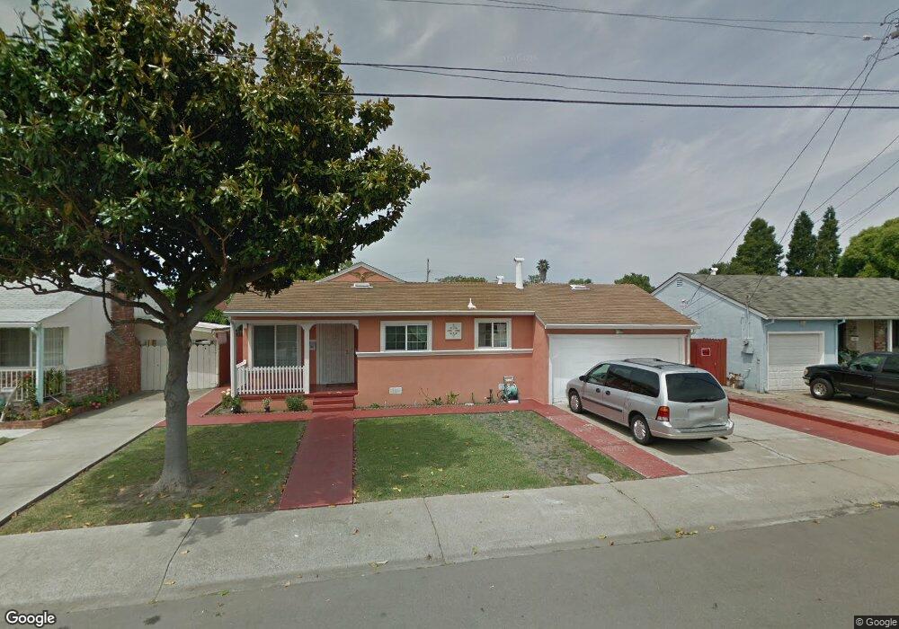
15089 Swenson St San Leandro, CA 94579
Washington Manor-Bonaire NeighborhoodEstimated Value: $747,834 - $788,000
3
Beds
1
Bath
1,076
Sq Ft
$709/Sq Ft
Est. Value
About This Home
This home is located at 15089 Swenson St, San Leandro, CA 94579 and is currently estimated at $762,959, approximately $709 per square foot. 15089 Swenson St is a home located in Alameda County with nearby schools including Dayton Elementary School, Washington Manor Middle School, and Arroyo High School.
Ownership History
Date
Name
Owned For
Owner Type
Purchase Details
Closed on
Apr 9, 2001
Sold by
Gallegos Doreen
Bought by
Cazares Ivane M and Cazares Jaime
Current Estimated Value
Home Financials for this Owner
Home Financials are based on the most recent Mortgage that was taken out on this home.
Original Mortgage
$216,000
Outstanding Balance
$79,389
Interest Rate
6.98%
Estimated Equity
$683,570
Purchase Details
Closed on
Aug 20, 1999
Sold by
Gallegos Manuel C
Bought by
Gallegos Manuel C and Manuel C Gallegos Trust
Create a Home Valuation Report for This Property
The Home Valuation Report is an in-depth analysis detailing your home's value as well as a comparison with similar homes in the area
Home Values in the Area
Average Home Value in this Area
Purchase History
| Date | Buyer | Sale Price | Title Company |
|---|---|---|---|
| Cazares Ivane M | $270,000 | New Century Title Company | |
| Gallegos Manuel C | -- | -- |
Source: Public Records
Mortgage History
| Date | Status | Borrower | Loan Amount |
|---|---|---|---|
| Open | Cazares Ivane M | $216,000 | |
| Closed | Cazares Ivane M | $27,000 |
Source: Public Records
Tax History Compared to Growth
Tax History
| Year | Tax Paid | Tax Assessment Tax Assessment Total Assessment is a certain percentage of the fair market value that is determined by local assessors to be the total taxable value of land and additions on the property. | Land | Improvement |
|---|---|---|---|---|
| 2025 | $5,923 | $454,058 | $138,317 | $322,741 |
| 2024 | $5,923 | $445,020 | $135,606 | $316,414 |
| 2023 | $5,899 | $443,157 | $132,947 | $310,210 |
| 2022 | $5,808 | $427,470 | $130,341 | $304,129 |
| 2021 | $5,645 | $418,951 | $127,785 | $298,166 |
| 2020 | $5,518 | $421,584 | $126,475 | $295,109 |
| 2019 | $5,524 | $413,320 | $123,996 | $289,324 |
| 2018 | $5,202 | $405,217 | $121,565 | $283,652 |
| 2017 | $4,961 | $397,273 | $119,182 | $278,091 |
| 2016 | $4,842 | $389,485 | $116,845 | $272,640 |
| 2015 | $4,735 | $383,637 | $115,091 | $268,546 |
| 2014 | $4,664 | $376,125 | $112,837 | $263,288 |
Source: Public Records
Map
Nearby Homes
- 688 Garside Ct
- 15049 Kesterson St
- 619 Beatrice St
- 15009 Kesterson St
- 700 Fargo Ave Unit 2
- 700 Fargo Ave Unit 5
- 700 Fargo Ave Unit 12
- 700 Fargo Ave Unit 1
- 720 Fargo Ave Unit 14
- 650 Fargo Ave Unit 4
- 670 Fargo Ave Unit 5
- 747 Lewelling Blvd
- 747 Lewelling Blvd Unit SPC 22
- 874 Lewelling Blvd
- 15356 Sullivan Ave
- 391 Anza Way
- 840 Woodgate Dr
- 15535 Sedgeman St
- 15382 Andover St
- 15102 Chapel Ct
- 15081 Swenson St
- 15097 Swenson St
- 15080 Crosby St
- 15072 Crosby St
- 15073 Swenson St
- 15113 Swenson St
- 15092 Crosby St
- 15088 Swenson St
- 15064 Crosby St
- 15080 Swenson St
- 15090 Swenson St
- 15110 Crosby St
- 15065 Swenson St
- 15121 Swenson St
- 15072 Swenson St
- 15056 Crosby St
- 15120 Crosby St
- 15089 Alexandria St
- 15064 Swenson St
- 15057 Swenson St