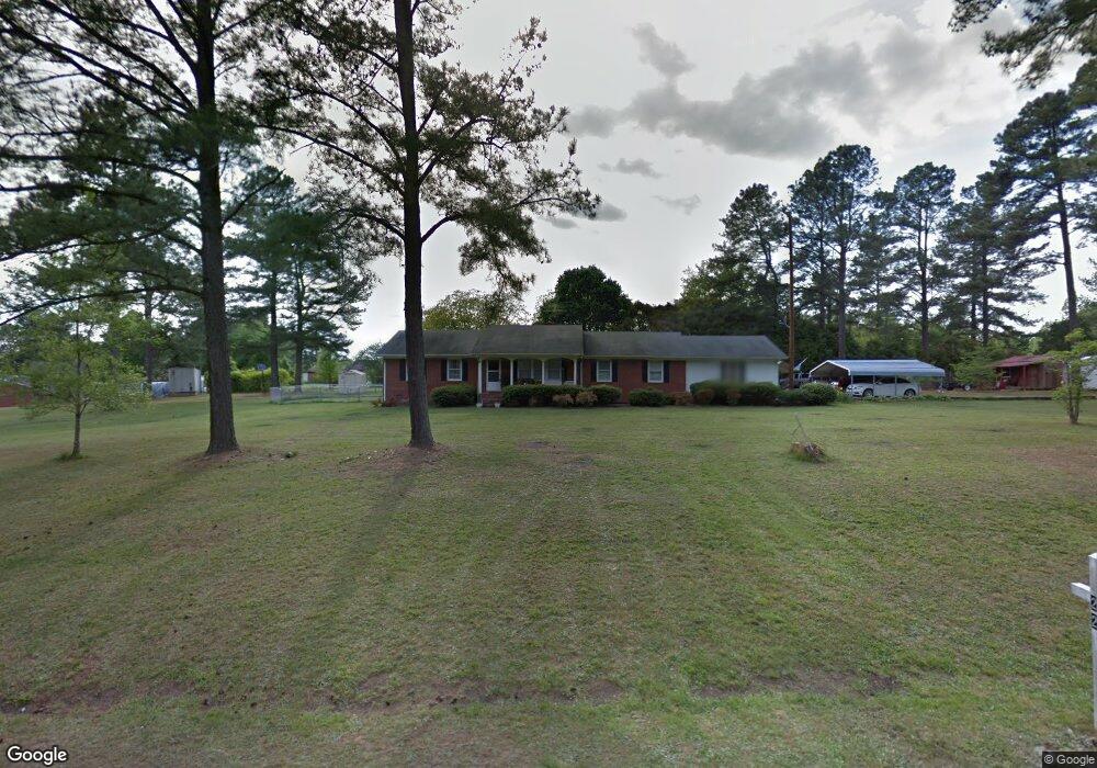
1515 Nc 561 Hwy Louisburg, NC 27549
Estimated Value: $252,000 - $399,726
3
Beds
3
Baths
1,800
Sq Ft
$183/Sq Ft
Est. Value
About This Home
This home is located at 1515 Nc 561 Hwy, Louisburg, NC 27549 and is currently estimated at $328,682, approximately $182 per square foot. 1515 Nc 561 Hwy is a home located in Franklin County with nearby schools including Louisburg Elementary School, Terrell Lane Middle School, and Louisburg High School.
Ownership History
Date
Name
Owned For
Owner Type
Purchase Details
Closed on
Oct 10, 2019
Sold by
Groves Gloria T
Bought by
Lynch Brenda S
Current Estimated Value
Purchase Details
Closed on
Oct 9, 2019
Sold by
Groves Gloria T
Bought by
Groves Brenda L
Purchase Details
Closed on
Mar 5, 2010
Sold by
Barnes James D
Bought by
Groves Gloria T
Home Financials for this Owner
Home Financials are based on the most recent Mortgage that was taken out on this home.
Original Mortgage
$127,000
Interest Rate
4.75%
Mortgage Type
New Conventional
Create a Home Valuation Report for This Property
The Home Valuation Report is an in-depth analysis detailing your home's value as well as a comparison with similar homes in the area
Home Values in the Area
Average Home Value in this Area
Purchase History
| Date | Buyer | Sale Price | Title Company |
|---|---|---|---|
| Lynch Brenda S | -- | None Available | |
| Groves Brenda L | -- | None Available | |
| Groves Gloria T | $126,000 | None Available |
Source: Public Records
Mortgage History
| Date | Status | Borrower | Loan Amount |
|---|---|---|---|
| Previous Owner | Groves Gloria T | $127,000 |
Source: Public Records
Tax History Compared to Growth
Tax History
| Year | Tax Paid | Tax Assessment Tax Assessment Total Assessment is a certain percentage of the fair market value that is determined by local assessors to be the total taxable value of land and additions on the property. | Land | Improvement |
|---|---|---|---|---|
| 2025 | $1,138 | $358,870 | $53,080 | $305,790 |
| 2024 | $1,138 | $358,870 | $53,080 | $305,790 |
| 2023 | $1,044 | $224,110 | $16,500 | $207,610 |
| 2022 | $1,144 | $224,110 | $16,500 | $207,610 |
| 2021 | $1,056 | $224,110 | $16,500 | $207,610 |
| 2020 | $1,050 | $224,110 | $16,500 | $207,610 |
| 2019 | $197 | $22,190 | $16,500 | $5,690 |
| 2018 | $669 | $142,240 | $16,500 | $125,740 |
| 2017 | $374 | $73,930 | $15,000 | $58,930 |
| 2016 | $387 | $73,930 | $15,000 | $58,930 |
| 2015 | $385 | $73,930 | $15,000 | $58,930 |
| 2014 | $365 | $73,930 | $15,000 | $58,930 |
Source: Public Records
Map
Nearby Homes
- 592 Perdues Rd
- 376 T K Allen Rd
- 2329 N Carolina 561
- 45 Leisure Ln
- 55 Leisure Ln
- 70 Leisure Ln
- 08 Tillery Dr
- 06 Tillery Dr
- 11 Tillery Dr
- 09 Tillery Dr
- 109 Drew St
- 0 Zinnia Ct Unit 10129898
- 7.69 Acres N Carolina 561
- 23.20 Acre N Carolina 561
- 10.26 Acre N Carolina 561
- 0-0 Halifax Rd
- 491 Nc 56 Hwy E
- 126 Person St
- 311 Nc 56 Hwy E
- 101 Briarwood Ct
- 1515 Nc 561 Hwy
- 244 Perdues Rd
- 1515 N Carolina 561
- 1515 Lester Rd
- 1503 Nc 561 Hwy
- 1503 Nc 561 Hwy
- 1499 Nc 561 Hwy
- 229 Perdues Rd
- 1483 Nc 561 Hwy
- 205 Perdues Rd
- 201 Perdues Rd
- 1471 Nc 561 Hwy
- 301 Perdues Rd
- 177 Perdues Rd
- 1593 Nc 561 Hwy
- 1439 Nc 561 Hwy
- 157 Perdues Rd
- 1435 Nc 561 Hwy
- 1619 Nc 561 Hwy
- 129 Perdues Rd