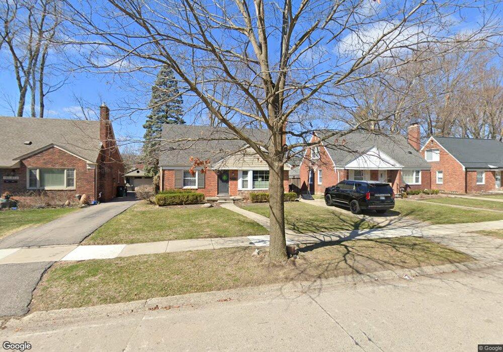
1517 Marywood Dr Royal Oak, MI 48067
Estimated Value: $357,927 - $470,000
3
Beds
3
Baths
1,350
Sq Ft
$300/Sq Ft
Est. Value
About This Home
This home is located at 1517 Marywood Dr, Royal Oak, MI 48067 and is currently estimated at $404,482, approximately $299 per square foot. 1517 Marywood Dr is a home located in Oakland County with nearby schools including Northwood Elementary School, Royal Oak Middle School, and Royal Oak High School.
Ownership History
Date
Name
Owned For
Owner Type
Purchase Details
Closed on
May 17, 2021
Sold by
Most Kate D
Bought by
Most Jared T and Most Kate D
Current Estimated Value
Purchase Details
Closed on
Dec 10, 2020
Sold by
Most Kate D and Morgan Kate Denise
Bought by
Most Kate D
Purchase Details
Closed on
Mar 1, 2010
Sold by
Zablocki David and Zablocki Cheryl A
Bought by
Morgan Kate Denise
Purchase Details
Closed on
Jun 25, 2002
Sold by
Miller William R
Bought by
Bederka Cheryl
Purchase Details
Closed on
Mar 18, 1999
Sold by
Miller William R
Bought by
Miller William R
Create a Home Valuation Report for This Property
The Home Valuation Report is an in-depth analysis detailing your home's value as well as a comparison with similar homes in the area
Home Values in the Area
Average Home Value in this Area
Purchase History
| Date | Buyer | Sale Price | Title Company |
|---|---|---|---|
| Most Jared T | -- | None Available | |
| Most Kate D | -- | First American Title | |
| Morgan Kate Denise | $177,000 | None Available | |
| Bederka Cheryl | $216,500 | -- | |
| Miller William R | -- | -- |
Source: Public Records
Tax History Compared to Growth
Tax History
| Year | Tax Paid | Tax Assessment Tax Assessment Total Assessment is a certain percentage of the fair market value that is determined by local assessors to be the total taxable value of land and additions on the property. | Land | Improvement |
|---|---|---|---|---|
| 2024 | $3,882 | $149,610 | $0 | $0 |
| 2022 | $3,848 | $133,010 | $0 | $0 |
| 2020 | $3,165 | $118,560 | $0 | $0 |
| 2018 | $3,848 | $105,720 | $0 | $0 |
| 2017 | $3,699 | $105,720 | $0 | $0 |
| 2015 | -- | $97,660 | $0 | $0 |
| 2014 | -- | $90,230 | $0 | $0 |
| 2011 | -- | $86,320 | $0 | $0 |
Source: Public Records
Map
Nearby Homes
- 719 W 12 Mile Rd
- 122 Euclid Ave
- 1028 Edgewood Dr
- 1821 N Washington Ave
- 1828 N Lafayette Ave
- 912 Woodsboro Dr
- 1833 N Washington Ave
- 606 Catalpa Dr
- 410 Crane Ave
- 227 W Houstonia Ave
- 908 N Maple Ave
- 508 W Houstonia Ave
- 2115 Marywood Dr
- 127 La Plaza Ct
- 307 Marlin Ave
- 1319 Woodsboro Dr
- 934 Lockwood Rd
- 334 Marlin Ave
- 1721 Forestdale Ct
- 1103 Fernwood Rd
- 1523 Marywood Dr
- 1513 Marywood Dr
- 1527 Marywood Dr
- 1507 Marywood Dr
- 1516 Edgewood Dr
- 1522 Edgewood Dr
- 1512 Edgewood Dr
- 1531 Marywood Dr
- 1503 Marywood Dr
- 1526 Edgewood Dr
- 1506 Edgewood Dr
- 1603 Marywood Dr
- 1530 Edgewood Dr
- 1502 Edgewood Dr
- 1530 Marywood Dr
- 424 Woodsboro Dr
- 1520 Marywood Dr
- 1602 Edgewood Dr
- 1607 Marywood Dr
- 1431 Marywood Dr