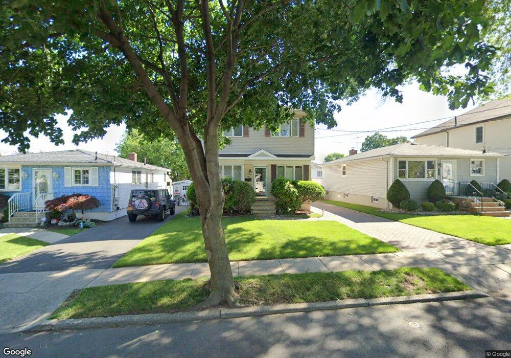
152 Atlantic Ave Staten Island, NY 10304
Dongan Hills NeighborhoodEstimated Value: $864,839 - $946,000
--
Bed
4
Baths
1,728
Sq Ft
$521/Sq Ft
Est. Value
About This Home
This home is located at 152 Atlantic Ave, Staten Island, NY 10304 and is currently estimated at $899,710, approximately $520 per square foot. 152 Atlantic Ave is a home located in Richmond County with nearby schools including P.S. 11 Thomas Dongan School, Is 2 George L Egbert, and New Dorp High School.
Ownership History
Date
Name
Owned For
Owner Type
Purchase Details
Closed on
Jan 17, 2018
Sold by
Mota Anibal and Mota Mercedes B
Bought by
Bannon Christopher J and Bannon Nicole M
Current Estimated Value
Home Financials for this Owner
Home Financials are based on the most recent Mortgage that was taken out on this home.
Original Mortgage
$76,000
Outstanding Balance
$64,119
Interest Rate
3.93%
Mortgage Type
New Conventional
Estimated Equity
$835,591
Create a Home Valuation Report for This Property
The Home Valuation Report is an in-depth analysis detailing your home's value as well as a comparison with similar homes in the area
Home Values in the Area
Average Home Value in this Area
Purchase History
| Date | Buyer | Sale Price | Title Company |
|---|---|---|---|
| Bannon Christopher J | $640,000 | Stewart Title Insurance Comp |
Source: Public Records
Mortgage History
| Date | Status | Borrower | Loan Amount |
|---|---|---|---|
| Open | Bannon Christopher J | $76,000 |
Source: Public Records
Tax History Compared to Growth
Tax History
| Year | Tax Paid | Tax Assessment Tax Assessment Total Assessment is a certain percentage of the fair market value that is determined by local assessors to be the total taxable value of land and additions on the property. | Land | Improvement |
|---|---|---|---|---|
| 2025 | $7,211 | $57,960 | $6,539 | $51,421 |
| 2024 | $7,211 | $51,540 | $6,938 | $44,602 |
| 2023 | $6,878 | $33,869 | $6,026 | $27,843 |
| 2022 | $6,761 | $51,420 | $9,960 | $41,460 |
| 2021 | $7,074 | $42,900 | $9,960 | $32,940 |
| 2020 | $6,712 | $37,020 | $9,960 | $27,060 |
| 2019 | $6,258 | $36,300 | $9,960 | $26,340 |
| 2018 | $5,753 | $28,224 | $6,780 | $21,444 |
| 2017 | $5,401 | $28,224 | $9,010 | $19,214 |
| 2016 | $5,250 | $28,011 | $8,643 | $19,368 |
| 2015 | $4,184 | $26,426 | $7,308 | $19,118 |
| 2014 | $4,184 | $24,931 | $8,095 | $16,836 |
Source: Public Records
Map
Nearby Homes
- 34 Bear St
- 137 Delaware Ave
- 119 Raritan Ave
- 102 Burgher Ave
- 453 N Railroad Ave
- 0 Hylan Blvd Unit 2405533
- 0 Hylan Blvd Unit 11348978
- 163 Cromwell Ave Unit 3B
- 165 Cromwell Ave Unit 3C
- 132 S Railroad Ave
- 91 Alter Ave
- 32 Remsen St
- 90 Alter Ave
- 240 Alter Ave
- 32 Henry Place
- 65 Alter Ave
- 40 Hancock St
- 286 Raritan Ave
- 2 Remsen St
- 287 Alter Ave
- 148 Atlantic Ave
- 156 Atlantic Ave
- 160 Atlantic Ave
- 144 Atlantic Ave
- 165 Raritan Ave
- 159 Raritan Ave
- 171 Raritan Ave
- 164 Atlantic Ave
- 155 Raritan Ave
- 138 Atlantic Ave
- 153 Atlantic Ave
- 175 Raritan Ave
- 151 Raritan Ave
- 157 Atlantic Ave
- 147 Atlantic Ave
- 168 Atlantic Ave
- 161 Atlantic Ave
- 149 Raritan Ave
- 179 Raritan Ave
- 139 Atlantic Ave