Estimated Value: $382,220 - $404,000
3
Beds
2
Baths
1,128
Sq Ft
$347/Sq Ft
Est. Value
About This Home
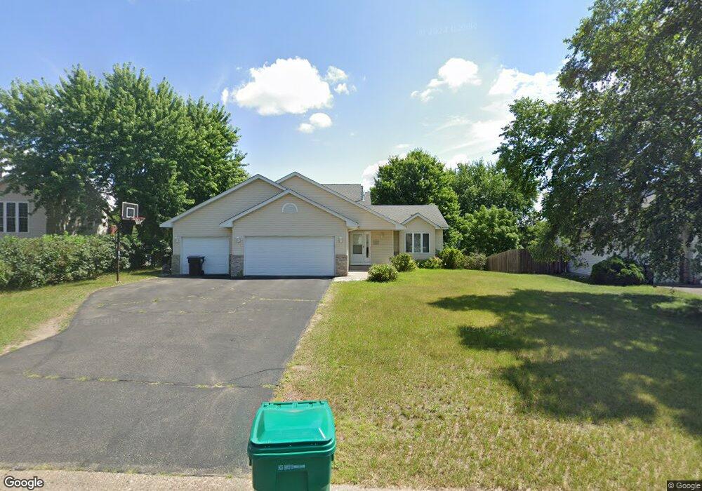
This home is located at 15231 Uranium St NW, Anoka, MN 55303 and is currently estimated at $391,555, approximately $347 per square foot. 15231 Uranium St NW is a home located in Anoka County with nearby schools including Ramsey Elementary School, Anoka Middle School for the Arts - Fred Moor Campus, and Anoka Senior High School.
Ownership History
Date
Name
Owned For
Owner Type
Purchase Details
Closed on
May 20, 2004
Sold by
Lenhart Douglas J and Lenhart Hillary O
Bought by
Anderson David Jeffrey and Anderson Connie Lynn
Current Estimated Value
Purchase Details
Closed on
Jun 11, 1999
Sold by
Sharp Holding Company
Bought by
Lenhart Douglas J and Lenhart Hillary O
Purchase Details
Closed on
May 18, 1998
Sold by
Residential Development Inc
Bought by
Sharp Holding Company
Create a Home Valuation Report for This Property
The Home Valuation Report is an in-depth analysis detailing your home's value as well as a comparison with similar homes in the area
Home Values in the Area
Average Home Value in this Area
Purchase History
| Date | Buyer | Sale Price | Title Company |
|---|---|---|---|
| Anderson David Jeffrey | $240,000 | -- | |
| Lenhart Douglas J | $149,900 | -- | |
| Sharp Holding Company | $28,900 | -- |
Source: Public Records
Tax History Compared to Growth
Tax History
| Year | Tax Paid | Tax Assessment Tax Assessment Total Assessment is a certain percentage of the fair market value that is determined by local assessors to be the total taxable value of land and additions on the property. | Land | Improvement |
|---|---|---|---|---|
| 2025 | $3,714 | $346,200 | $88,000 | $258,200 |
| 2024 | $3,714 | $339,000 | $81,900 | $257,100 |
| 2023 | $3,453 | $340,200 | $78,000 | $262,200 |
| 2022 | $3,028 | $337,400 | $65,200 | $272,200 |
| 2021 | $2,838 | $271,500 | $54,000 | $217,500 |
| 2020 | $2,858 | $256,200 | $51,000 | $205,200 |
| 2019 | $2,714 | $250,400 | $51,000 | $199,400 |
| 2018 | $2,664 | $232,900 | $0 | $0 |
| 2017 | $2,378 | $222,100 | $0 | $0 |
| 2016 | $2,425 | $199,200 | $0 | $0 |
| 2015 | -- | $199,200 | $49,000 | $150,200 |
| 2014 | -- | $170,700 | $38,000 | $132,700 |
Source: Public Records
Map
Nearby Homes
- 15160 Quicksilver St NW
- 15363 Radium St NW
- 5907 151st Ln NW
- 5845 151st Ln NW
- 5901 151st Ln NW
- 5831 151st Ln NW
- 5803 151st Ln NW
- 5817 151st Ln NW
- 14683 Sodium St NW
- 5696 154th Cove NW
- 15800 Nowthen Blvd NW
- 5641 149th Ln NW
- 6007 146th Ave NW
- 14795 Krypton Ct NW
- 14573 Krypton St NW
- 6295 144th Ave NW
- 7025 156th Ave NW
- 7041 147th Ln NW
- 7080 148th Ave NW
- 16042 Iodine St NW
- 15211 Uranium St NW
- 15251 Uranium St NW
- 15250 Sodium St NW
- 15220 Sodium St NW
- 15271 Uranium St NW
- 6211 152nd Ave NW
- 15270 Sodium St NW
- 15210 Sodium St NW
- 15280 Sodium St NW
- 15250 Uranium St NW
- 15281 Uranium St NW
- 6221 152nd Ave NW
- 6200 152nd Ave NW
- 6210 152nd Ave NW
- 15190 Sodium St NW
- 6220 152nd Ave NW
- 15290 Sodium St NW
- 15291 Uranium St NW
- 15270 Uranium St NW
- 6231 152nd Ave NW