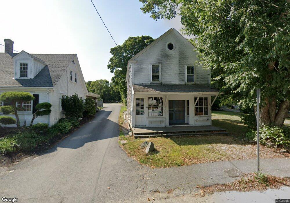
153 Route 6a Yarmouth Port, MA 02675
Yarmouth Port NeighborhoodEstimated Value: $361,290
1
Bed
2
Baths
1,845
Sq Ft
$196/Sq Ft
Est. Value
About This Home
This home is located at 153 Route 6a, Yarmouth Port, MA 02675 and is currently estimated at $361,290, approximately $195 per square foot. 153 Route 6a is a home located in Barnstable County with nearby schools including Dennis-Yarmouth Regional High School, Sturgis Charter Public School, and Trinity Christian Academy of Cape Cod.
Ownership History
Date
Name
Owned For
Owner Type
Purchase Details
Closed on
Aug 20, 2024
Sold by
Tatibouet Grp Atlantic Ll
Bought by
Tidelands Rt and Tatibouet
Current Estimated Value
Purchase Details
Closed on
Sep 30, 2019
Sold by
Bass River Development
Bought by
Tatibouet Group Atlantic
Purchase Details
Closed on
Sep 26, 2017
Sold by
Golner Joseph H
Bought by
Bass River Development
Purchase Details
Closed on
Oct 31, 1980
Bought by
Kettell-Golner Marjorie E
Create a Home Valuation Report for This Property
The Home Valuation Report is an in-depth analysis detailing your home's value as well as a comparison with similar homes in the area
Home Values in the Area
Average Home Value in this Area
Purchase History
| Date | Buyer | Sale Price | Title Company |
|---|---|---|---|
| Tidelands Rt | -- | None Available | |
| Tidelands Rt | -- | None Available | |
| Tatibouet Group Atlantic | $208,000 | -- | |
| Bass River Development | $210,000 | -- | |
| Kettell-Golner Marjorie E | -- | -- |
Source: Public Records
Tax History Compared to Growth
Tax History
| Year | Tax Paid | Tax Assessment Tax Assessment Total Assessment is a certain percentage of the fair market value that is determined by local assessors to be the total taxable value of land and additions on the property. | Land | Improvement |
|---|---|---|---|---|
| 2025 | $1,571 | $221,900 | $63,000 | $158,900 |
| 2024 | $1,638 | $221,900 | $63,000 | $158,900 |
| 2023 | $1,188 | $146,500 | $60,300 | $86,200 |
| 2022 | $1,130 | $123,100 | $46,500 | $76,600 |
| 2021 | $1,177 | $123,100 | $46,500 | $76,600 |
| 2020 | $1,093 | $109,300 | $37,400 | $71,900 |
| 2019 | $1,104 | $109,300 | $37,400 | $71,900 |
| 2018 | $1,125 | $109,300 | $37,400 | $71,900 |
| 2017 | $1,095 | $109,300 | $37,400 | $71,900 |
| 2016 | $1,091 | $109,300 | $37,400 | $71,900 |
| 2015 | $1,238 | $123,300 | $50,900 | $72,400 |
Source: Public Records
Map
Nearby Homes
- 162 Route 6a
- 116 Main St
- 116 Main (Route 6a) St
- 186 Route 6a
- 112 Main St
- 56 Wharf Ln
- 4390 Main St
- 25 Congressional Dr
- 105 Old Hyannis Rd
- 33 Midpine Rd
- 371 Route 6a
- 81 Desert Sands Ln
- 99 Old Hyannis Rd
- 933-935 W Yarmouth Rd
- 111 Old Hyannis Rd
- 882 W Yarmouth Rd
- 23 Dauphine Dr
- 65 Oakmont Rd
- 10 Balsam Way
- 24 Minnetuxet Way
- 153 Massachusetts 6a
- 157 Route 6a
- 143 Route 6a
- 159 Route 6a
- 156 Main (Route 6a) St
- 152 Route 6a
- 152 Massachusetts 6a
- 146 Route 6a
- 139 Route 6a
- 141 Route 6a
- 137 Route 6a
- 142 Route 6a
- 165 Route 6a
- 138 Hallet (Rte 6a)
- 162 Route 6a Unit D
- 152 Main St
- 162 Old King's Hwy
- 162 Main St
- 18 N Sandyside Ln
- 156 Route 6a