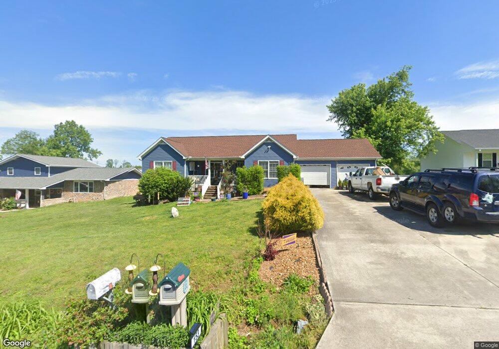
153 Tara Dr Cookeville, TN 38501
Estimated Value: $276,000 - $327,000
--
Bed
2
Baths
1,466
Sq Ft
$200/Sq Ft
Est. Value
About This Home
This home is located at 153 Tara Dr, Cookeville, TN 38501 and is currently estimated at $292,812, approximately $199 per square foot. 153 Tara Dr is a home located in Putnam County with nearby schools including Cane Creek Elementary School, Upperman Middle School, and Upperman High School.
Ownership History
Date
Name
Owned For
Owner Type
Purchase Details
Closed on
Sep 26, 2007
Sold by
Joel Cowan
Bought by
Cowan James J and Cowan Dylcia J
Current Estimated Value
Home Financials for this Owner
Home Financials are based on the most recent Mortgage that was taken out on this home.
Original Mortgage
$105,560
Outstanding Balance
$66,588
Interest Rate
6.41%
Estimated Equity
$226,224
Purchase Details
Closed on
Jan 24, 2006
Bought by
Cowan Joel and Cowan Dorothy Cowan
Purchase Details
Closed on
Jul 2, 1996
Bought by
Suggs Larry
Purchase Details
Closed on
Aug 12, 1974
Bought by
Suggs William E and Suggs Lucille P
Create a Home Valuation Report for This Property
The Home Valuation Report is an in-depth analysis detailing your home's value as well as a comparison with similar homes in the area
Home Values in the Area
Average Home Value in this Area
Purchase History
| Date | Buyer | Sale Price | Title Company |
|---|---|---|---|
| Cowan James J | $131,600 | -- | |
| Cowan Joel | $12,000 | -- | |
| Suggs Larry | $90,000 | -- | |
| Suggs William E | -- | -- |
Source: Public Records
Mortgage History
| Date | Status | Borrower | Loan Amount |
|---|---|---|---|
| Open | Suggs William E | $105,560 |
Source: Public Records
Tax History Compared to Growth
Tax History
| Year | Tax Paid | Tax Assessment Tax Assessment Total Assessment is a certain percentage of the fair market value that is determined by local assessors to be the total taxable value of land and additions on the property. | Land | Improvement |
|---|---|---|---|---|
| 2024 | $1,162 | $43,700 | $5,750 | $37,950 |
| 2023 | $1,162 | $43,700 | $5,750 | $37,950 |
| 2022 | $1,080 | $43,700 | $5,750 | $37,950 |
| 2021 | $1,080 | $43,700 | $5,750 | $37,950 |
| 2020 | $675 | $43,700 | $5,750 | $37,950 |
| 2019 | $1,026 | $35,050 | $5,750 | $29,300 |
| 2018 | $957 | $35,050 | $5,750 | $29,300 |
| 2017 | $957 | $35,050 | $5,750 | $29,300 |
| 2016 | $957 | $35,050 | $5,750 | $29,300 |
| 2015 | $983 | $35,050 | $5,750 | $29,300 |
| 2014 | $937 | $33,389 | $0 | $0 |
Source: Public Records
Map
Nearby Homes
- 270 Locust Grove Rd
- 279 Willow Brook Dr
- 2911 Grand Ridge Dr
- 2136 W Broad St
- 500 N McBroom Chapel Rd
- 2.52 St
- 0 Corner of W Broad St & Tn Ave Unit RTC2794105
- 1957 W Broad St
- Lot 3 Miller
- 4131 Charlton Square
- 4060 Charlton Square
- 2.52 ac W Broad St
- 918 Faye Dr
- 1711 Creekside Dr
- 1775 Creekside Dr
- 553 County Farm Rd
- 4113 Buffalo Valley Rd
- 1408 Oak Grove Dr
- 2269 Plunk Whitson Rd