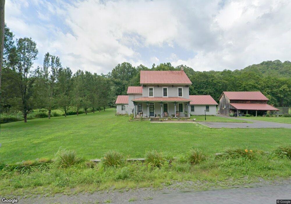
1537 State Route 487 Orangeville, PA 17859
Estimated Value: $226,498 - $467,000
--
Bed
--
Bath
2,351
Sq Ft
$151/Sq Ft
Est. Value
About This Home
This home is located at 1537 State Route 487, Orangeville, PA 17859 and is currently estimated at $354,125, approximately $150 per square foot. 1537 State Route 487 is a home located in Columbia County with nearby schools including Central Columbia Elementary School, Central Columbia Middle School, and Central Columbia Senior High School.
Ownership History
Date
Name
Owned For
Owner Type
Purchase Details
Closed on
Mar 24, 2017
Sold by
Luschas Alvin J and Estate Of Carilu M Lehman
Bought by
Lehman Todd D and Lehman Julia L
Current Estimated Value
Purchase Details
Closed on
Sep 21, 2005
Sold by
Buyers Elsie P
Bought by
Lehman Melvin M and Lehman Carilu M
Create a Home Valuation Report for This Property
The Home Valuation Report is an in-depth analysis detailing your home's value as well as a comparison with similar homes in the area
Home Values in the Area
Average Home Value in this Area
Purchase History
| Date | Buyer | Sale Price | Title Company |
|---|---|---|---|
| Lehman Todd D | -- | None Available | |
| Lehman Melvin M | $235,000 | None Available |
Source: Public Records
Tax History Compared to Growth
Tax History
| Year | Tax Paid | Tax Assessment Tax Assessment Total Assessment is a certain percentage of the fair market value that is determined by local assessors to be the total taxable value of land and additions on the property. | Land | Improvement |
|---|---|---|---|---|
| 2025 | $2,614 | $36,751 | $0 | $0 |
| 2024 | $2,514 | $36,751 | $6,893 | $29,858 |
| 2023 | $2,385 | $36,751 | $6,893 | $29,858 |
| 2022 | $2,238 | $36,751 | $6,893 | $29,858 |
| 2021 | $2,238 | $36,751 | $6,893 | $29,858 |
| 2020 | $2,159 | $36,751 | $6,893 | $29,858 |
| 2019 | $2,113 | $36,751 | $6,893 | $29,858 |
| 2018 | $2,113 | $36,751 | $6,893 | $29,858 |
| 2017 | $3,554 | $62,642 | $6,893 | $55,749 |
| 2016 | -- | $62,642 | $6,893 | $55,749 |
| 2015 | -- | $62,642 | $6,893 | $55,749 |
| 2014 | -- | $62,642 | $6,893 | $55,749 |
Source: Public Records
Map
Nearby Homes
- 139 Rotary St
- 135 Ash St
- 107 E Pebble Ln
- 14 Fowlersville Rd
- 34 Fowlersville Rd
- 21 Levi St
- 63 Brentwood Cir
- 0 Alliance Park Lot 6 Dr
- 53 Fox Hollow Rd
- 0 Alliance Park Dr
- 568 Beilys Rd
- LOT #3 Sawmill Rd
- 11 Amanda Dr
- 9 Crestmont Cir
- 1246 Cherry St
- 1251 Chestnut St
- 1277 Cherry St
- 1219 Maple St
- 925 Mcguire Rd
- 4 Kent Rd