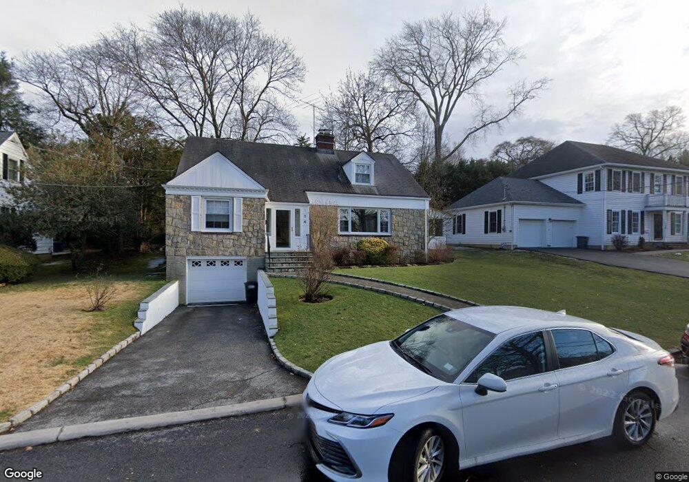
154 Birch Brook Rd Bronxville, NY 10708
Cedar Knolls NeighborhoodEstimated Value: $1,020,338 - $1,304,000
3
Beds
2
Baths
2,353
Sq Ft
$509/Sq Ft
Est. Value
About This Home
This home is located at 154 Birch Brook Rd, Bronxville, NY 10708 and is currently estimated at $1,197,585, approximately $508 per square foot. 154 Birch Brook Rd is a home located in Westchester County with nearby schools including St. Eugene School and Saint Joseph School.
Ownership History
Date
Name
Owned For
Owner Type
Purchase Details
Closed on
May 10, 1999
Sold by
Sousie Maria and Chung Maria A
Bought by
Bonarrigo Nicholas and Bonarrigo Adele
Current Estimated Value
Home Financials for this Owner
Home Financials are based on the most recent Mortgage that was taken out on this home.
Original Mortgage
$320,000
Interest Rate
8.11%
Mortgage Type
Unknown
Create a Home Valuation Report for This Property
The Home Valuation Report is an in-depth analysis detailing your home's value as well as a comparison with similar homes in the area
Home Values in the Area
Average Home Value in this Area
Purchase History
| Date | Buyer | Sale Price | Title Company |
|---|---|---|---|
| Bonarrigo Nicholas | $402,500 | First American Title Ins Co |
Source: Public Records
Mortgage History
| Date | Status | Borrower | Loan Amount |
|---|---|---|---|
| Previous Owner | Bonarrigo Nicholas | $320,000 |
Source: Public Records
Tax History Compared to Growth
Tax History
| Year | Tax Paid | Tax Assessment Tax Assessment Total Assessment is a certain percentage of the fair market value that is determined by local assessors to be the total taxable value of land and additions on the property. | Land | Improvement |
|---|---|---|---|---|
| 2024 | $2,388 | $13,400 | $3,900 | $9,500 |
| 2023 | $2,375 | $14,175 | $3,900 | $10,275 |
| 2022 | $2,796 | $15,880 | $3,900 | $11,980 |
| 2021 | $12,647 | $15,880 | $3,900 | $11,980 |
| 2020 | $12,554 | $15,880 | $3,900 | $11,980 |
| 2019 | $16,752 | $17,700 | $3,900 | $13,800 |
| 2018 | $13,144 | $17,700 | $3,900 | $13,800 |
| 2017 | $0 | $17,700 | $3,900 | $13,800 |
| 2016 | $14,820 | $17,700 | $3,900 | $13,800 |
| 2015 | -- | $17,700 | $3,900 | $13,800 |
| 2014 | -- | $17,700 | $3,900 | $13,800 |
| 2013 | -- | $17,700 | $3,900 | $13,800 |
Source: Public Records
Map
Nearby Homes
- 1523 Central Park Ave Unit 5F
- 1523 Central Park Ave Unit 14C
- 1523 Central Park Ave Unit 17B
- 212 Pondfield Rd W
- 1531 Central Park Ave Unit C-4
- 209 Pondfield Rd W
- 1537 Central Park Ave Unit E8
- 1543 Central Park Ave Unit F-04
- 1543 Central Park Ave Unit F8
- 1561 Central Park Ave Unit I-5
- 1561 Central Park Ave Unit I2
- 1549 Central Park Ave Unit G-11
- 10 Wiltshire St
- 682 Tuckahoe Rd Unit 4A
- 682 Tuckahoe Rd Unit 1A
- 1 Arlington St Unit 2B
- 46 Dellwood Rd
- 20 Witherell St
- 17 Winchester Ave Unit 1B
- 133 Pondfield Rd W Unit 2B
- 150 Birch Brook Rd
- 160 Birch Brook Rd
- 259 Pondfield Rd W
- 251 Pondfield Rd W
- 161 Birch Brook Rd
- 144 Birch Brook Rd
- 153 Birch Brook Rd
- 169 Birch Brook Rd
- 175 Dellwood Rd
- 272 Pondfield Rd W
- 262 Pondfield Rd W
- 138 Birch Brook Rd
- 266 Pondfield Rd W
- 258 Pondfield Rd W
- 145 Birch Brook Rd
- 250 Pondfield Rd W
- 151 Dellwood Rd
- 137 Birch Brook Rd
- 14 Barrington Rd
- 10 Barrington Rd