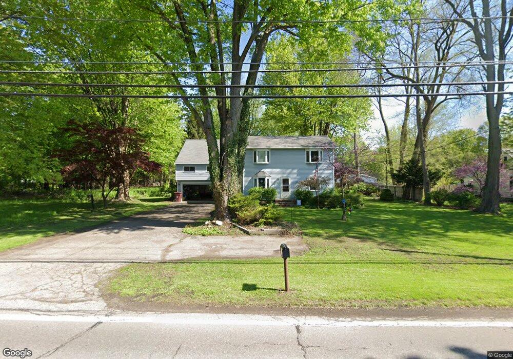
155 Hale Rd Painesville, OH 44077
Estimated Value: $258,647 - $313,000
4
Beds
3
Baths
2,064
Sq Ft
$135/Sq Ft
Est. Value
About This Home
This home is located at 155 Hale Rd, Painesville, OH 44077 and is currently estimated at $277,662, approximately $134 per square foot. 155 Hale Rd is a home located in Lake County with nearby schools including Henry F. Lamuth Middle School, Riverside Junior/Senior High School, and Summit Academy Community School - Painesville.
Ownership History
Date
Name
Owned For
Owner Type
Purchase Details
Closed on
Apr 15, 2016
Sold by
Gillette Carolyn L and Gillette Samuel T
Bought by
Gillette Carolyn L
Current Estimated Value
Purchase Details
Closed on
May 5, 2003
Sold by
Hinz Carolyn L and Hinz Carolyn L
Bought by
Gillette Samuel T and Gillette Carolyn L
Home Financials for this Owner
Home Financials are based on the most recent Mortgage that was taken out on this home.
Original Mortgage
$70,300
Interest Rate
5.29%
Mortgage Type
Purchase Money Mortgage
Create a Home Valuation Report for This Property
The Home Valuation Report is an in-depth analysis detailing your home's value as well as a comparison with similar homes in the area
Home Values in the Area
Average Home Value in this Area
Purchase History
| Date | Buyer | Sale Price | Title Company |
|---|---|---|---|
| Gillette Carolyn L | -- | None Available | |
| Gillette Samuel T | -- | Main Street Title Agency |
Source: Public Records
Mortgage History
| Date | Status | Borrower | Loan Amount |
|---|---|---|---|
| Closed | Gillette Samuel T | $70,300 |
Source: Public Records
Tax History Compared to Growth
Tax History
| Year | Tax Paid | Tax Assessment Tax Assessment Total Assessment is a certain percentage of the fair market value that is determined by local assessors to be the total taxable value of land and additions on the property. | Land | Improvement |
|---|---|---|---|---|
| 2024 | -- | $78,270 | $14,440 | $63,830 |
| 2023 | $7,148 | $65,600 | $10,470 | $55,130 |
| 2022 | $3,334 | $65,600 | $10,470 | $55,130 |
| 2021 | $3,346 | $65,600 | $10,470 | $55,130 |
| 2020 | $3,221 | $57,050 | $9,110 | $47,940 |
| 2019 | $3,246 | $57,050 | $9,110 | $47,940 |
| 2018 | $3,130 | $51,980 | $8,770 | $43,210 |
| 2017 | $3,004 | $51,980 | $8,770 | $43,210 |
| 2016 | $2,646 | $51,980 | $8,770 | $43,210 |
| 2015 | $2,475 | $51,980 | $8,770 | $43,210 |
| 2014 | $2,516 | $51,980 | $8,770 | $43,210 |
| 2013 | $2,459 | $51,980 | $8,770 | $43,210 |
Source: Public Records
Map
Nearby Homes
- 269 Hale Rd
- 1787 Muirfield Ln
- 108 Birch Dr
- 1809 Muirfield Ln
- 0 N Ridge Rd Unit 5110949
- 808 N Creek Dr
- 634 N Creek Dr
- 728 Bowhall Rd
- 1865 Marsh Ln Unit 1865
- 1978 Marsh Ln Unit 1978
- 720 N Creek Dr
- 1791 Muirfield Ln
- 1806 Muirfield Ln
- 751 Bacon Rd
- 500 Park Rd
- 1598 Bogie Ln
- 525 Morgan Dr
- 547 Greenside Dr
- 1788 Kirtstone Terrace
- 499 Sand Trap Cir