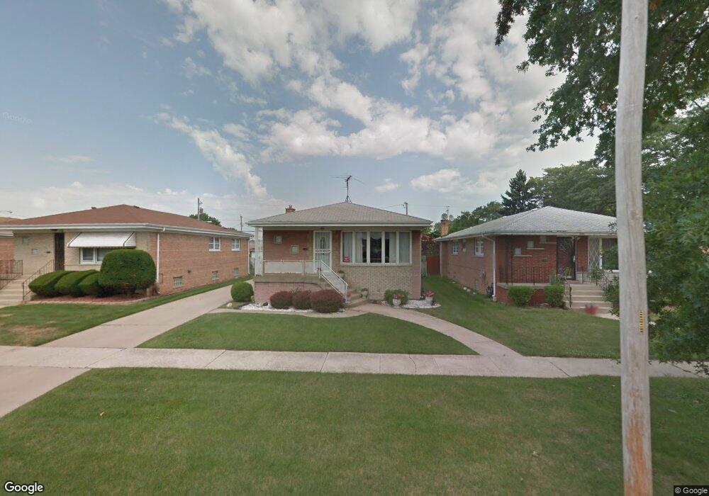
1556 Memorial Dr Calumet City, IL 60409
Estimated Value: $171,420 - $243,000
3
Beds
2
Baths
1,252
Sq Ft
$167/Sq Ft
Est. Value
About This Home
This home is located at 1556 Memorial Dr, Calumet City, IL 60409 and is currently estimated at $209,605, approximately $167 per square foot. 1556 Memorial Dr is a home located in Cook County with nearby schools including Diekman Elementary School, Carol Moseley Braun School, and Creative Communications Academy.
Ownership History
Date
Name
Owned For
Owner Type
Purchase Details
Closed on
Jun 12, 2007
Sold by
Galloway Jeffery M
Bought by
Scott Jeanie H and Galloway Jeffery M
Current Estimated Value
Purchase Details
Closed on
Sep 13, 2005
Sold by
Reynolds Lorraine A
Bought by
Galloway Jeffery M
Home Financials for this Owner
Home Financials are based on the most recent Mortgage that was taken out on this home.
Original Mortgage
$130,800
Outstanding Balance
$69,890
Interest Rate
5.83%
Mortgage Type
Fannie Mae Freddie Mac
Estimated Equity
$139,715
Create a Home Valuation Report for This Property
The Home Valuation Report is an in-depth analysis detailing your home's value as well as a comparison with similar homes in the area
Home Values in the Area
Average Home Value in this Area
Purchase History
| Date | Buyer | Sale Price | Title Company |
|---|---|---|---|
| Scott Jeanie H | -- | None Available | |
| Galloway Jeffery M | $163,500 | Residential Title Services |
Source: Public Records
Mortgage History
| Date | Status | Borrower | Loan Amount |
|---|---|---|---|
| Open | Galloway Jeffery M | $130,800 |
Source: Public Records
Tax History Compared to Growth
Tax History
| Year | Tax Paid | Tax Assessment Tax Assessment Total Assessment is a certain percentage of the fair market value that is determined by local assessors to be the total taxable value of land and additions on the property. | Land | Improvement |
|---|---|---|---|---|
| 2024 | $2,195 | $6,500 | $1,719 | $4,781 |
| 2023 | $1,444 | $6,500 | $1,719 | $4,781 |
| 2022 | $1,444 | $5,587 | $1,484 | $4,103 |
| 2021 | $637 | $5,587 | $1,484 | $4,103 |
| 2020 | $637 | $5,587 | $1,484 | $4,103 |
| 2019 | $0 | $4,578 | $1,250 | $3,328 |
| 2018 | $0 | $4,578 | $1,250 | $3,328 |
| 2017 | $351 | $4,578 | $1,250 | $3,328 |
| 2016 | $637 | $4,392 | $1,171 | $3,221 |
| 2015 | $654 | $4,392 | $1,171 | $3,221 |
| 2014 | $623 | $4,392 | $1,171 | $3,221 |
| 2013 | $3,133 | $5,275 | $1,171 | $4,104 |
Source: Public Records
Map
Nearby Homes
- 605 Hoxie Ave
- 508 Hoxie Ave
- 615 Hoxie Ave
- 518 Crandon Ave
- 605 Saginaw Ave
- 1758 Memorial Dr
- 452 Yates Ave
- 453 Hoxie Ave
- 618 Marquette Ave
- 519 Paxton Ave
- 627 Paxton Ave
- 1225 Memorial Dr
- 513 Merrill Ave
- 602 Merrill Ave
- 558 Muskegon Ave
- 412 Saginaw Ave
- 430 Marquette Ave
- 381 Yates Ave
- 383 Calhoun Ave
- 648 Muskegon Ave
- 1556 Memorial Dr
- 1560 Memorial Dr
- 1560 Memorial Dr
- 566 Bensley Ave
- 1566 Memorial Dr
- 1566 Memorial Dr
- 564 Bensley Ave
- 1572 Memorial Dr
- 1520 Memorial Dr
- 567 Yates Ave
- 560 Bensley Ave
- 1574 Memorial Dr
- 1555 Memorial Dr
- 1551 Memorial Dr
- 565 Yates Ave
- 567 Bensley Ave
- 1559 Memorial Dr
- 556 Bensley Ave
- 1563 Memorial Dr