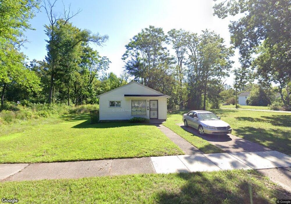
15810 Burgess St Detroit, MI 48223
Brightmoor NeighborhoodEstimated Value: $15,218 - $99,000
--
Bed
--
Bath
440
Sq Ft
$124/Sq Ft
Est. Value
About This Home
This home is located at 15810 Burgess St, Detroit, MI 48223 and is currently estimated at $54,739, approximately $124 per square foot. 15810 Burgess St is a home located in Wayne County with nearby schools including Ralph W. Emerson Elementary-Middle School, Charles L. Spain Elementary-Middle School, and Edward 'Duke' Ellington Conservatory of Music and Art.
Ownership History
Date
Name
Owned For
Owner Type
Purchase Details
Closed on
Jan 23, 2014
Sold by
Wayne County Treasurer
Bought by
Detroit Landbank Authority
Current Estimated Value
Purchase Details
Closed on
Oct 29, 2007
Sold by
Charter County Of Wayne Michigan
Bought by
Burrell Deborah P
Purchase Details
Closed on
Nov 20, 2006
Sold by
Wojtowicz Raymond J
Bought by
Norris Madisyn S
Purchase Details
Closed on
Feb 19, 2002
Sold by
R E Investments Inc
Bought by
Belsley Steven M
Purchase Details
Closed on
Jul 16, 1999
Sold by
Phoenix Real Estate Co
Bought by
R E Investments Inc
Create a Home Valuation Report for This Property
The Home Valuation Report is an in-depth analysis detailing your home's value as well as a comparison with similar homes in the area
Home Values in the Area
Average Home Value in this Area
Purchase History
| Date | Buyer | Sale Price | Title Company |
|---|---|---|---|
| Detroit Landbank Authority | -- | None Available | |
| Burrell Deborah P | $665 | None Available | |
| Norris Madisyn S | $500 | None Available | |
| Belsley Steven M | -- | -- | |
| R E Investments Inc | $9,000 | -- |
Source: Public Records
Tax History Compared to Growth
Tax History
| Year | Tax Paid | Tax Assessment Tax Assessment Total Assessment is a certain percentage of the fair market value that is determined by local assessors to be the total taxable value of land and additions on the property. | Land | Improvement |
|---|---|---|---|---|
| 2025 | -- | $0 | $0 | $0 |
| 2024 | -- | $0 | $0 | $0 |
| 2023 | $0 | $0 | $0 | $0 |
| 2022 | $0 | $0 | $0 | $0 |
| 2021 | $0 | $0 | $0 | $0 |
| 2020 | $53 | $0 | $0 | $0 |
| 2019 | $53 | $0 | $0 | $0 |
| 2018 | $0 | $0 | $0 | $0 |
| 2017 | -- | $0 | $0 | $0 |
| 2016 | $69 | $0 | $0 | $0 |
| 2015 | $69 | $0 | $0 | $0 |
| 2013 | $69 | $688 | $0 | $0 |
| 2010 | -- | $688 | $687 | $1 |
Source: Public Records
Map
Nearby Homes
- 15487 Greydale St
- 15835 Westbrook St
- 15726 Rockdale St
- 16146 Chapel St
- 15905 Westbrook St
- 16115 Westbrook St
- 15858 Westbrook St
- 15421 Westbrook St
- 15739 Dolphin St
- 16566 Bentler St
- 16122 Trinity St
- 15379 Dolphin St
- 16115 Burt Rd
- 15876 Burt Rd
- 16195 Burt Rd
- 15860 Pierson St
- 15841 Braile St
- 16616 Blackstone St
- 15471 Braile St
- 15158 Dacosta St
- 15818 Burgess St
- 15830 Burgess St
- 15831 Chapel St
- 15778 Burgess St
- 15838 Burgess St
- 15819 Chapel St
- 15801 Chapel St
- 15825 Chapel St
- 15774 Burgess St
- 15844 Burgess St
- 15773 Chapel St
- 15811 Burgess St
- 15817 Burgess St
- 15801 Burgess St
- 15823 Burgess St
- 15770 Burgess St
- 15852 Burgess St
- 15779 Burgess St
- 15839 Burgess St
- 15764 Burgess St