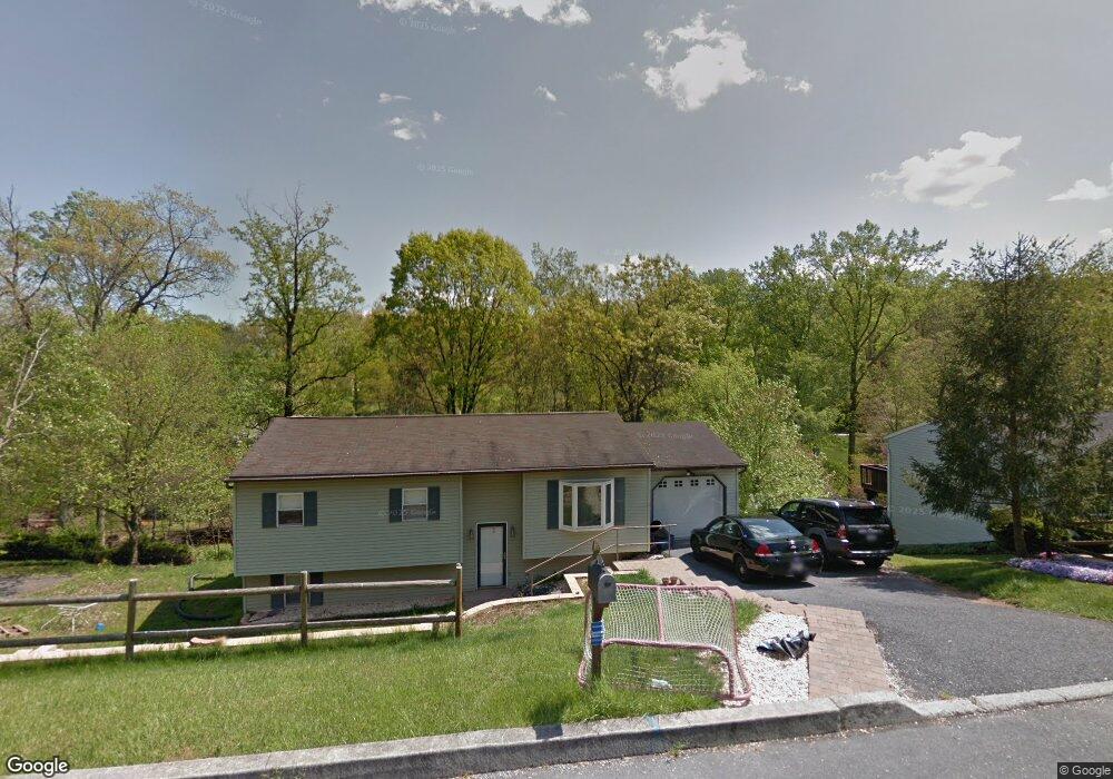
160 Sam Snead Cir Etters, PA 17319
Estimated Value: $258,000 - $286,000
3
Beds
2
Baths
1,080
Sq Ft
$251/Sq Ft
Est. Value
About This Home
This home is located at 160 Sam Snead Cir, Etters, PA 17319 and is currently estimated at $271,158, approximately $251 per square foot. 160 Sam Snead Cir is a home located in York County with nearby schools including Red Mill Elementary School, Crossroads Middle School, and Red Land Senior High School.
Ownership History
Date
Name
Owned For
Owner Type
Purchase Details
Closed on
Feb 27, 2003
Sold by
Dohrman Troy M and Dohrman Stacy L
Bought by
Winski Jason Paul and Winski Christy A
Current Estimated Value
Home Financials for this Owner
Home Financials are based on the most recent Mortgage that was taken out on this home.
Original Mortgage
$116,975
Outstanding Balance
$50,654
Interest Rate
5.98%
Mortgage Type
FHA
Estimated Equity
$220,504
Purchase Details
Closed on
May 16, 2001
Sold by
Dohrman Troy M and Dohrman Stacy L
Bought by
Dohrman Troy M and Dohrman Stacy L
Home Financials for this Owner
Home Financials are based on the most recent Mortgage that was taken out on this home.
Original Mortgage
$83,800
Interest Rate
7.05%
Create a Home Valuation Report for This Property
The Home Valuation Report is an in-depth analysis detailing your home's value as well as a comparison with similar homes in the area
Home Values in the Area
Average Home Value in this Area
Purchase History
| Date | Buyer | Sale Price | Title Company |
|---|---|---|---|
| Winski Jason Paul | $117,900 | -- | |
| Dohrman Troy M | -- | -- |
Source: Public Records
Mortgage History
| Date | Status | Borrower | Loan Amount |
|---|---|---|---|
| Open | Winski Jason Paul | $116,975 | |
| Previous Owner | Dohrman Troy M | $83,800 |
Source: Public Records
Tax History Compared to Growth
Tax History
| Year | Tax Paid | Tax Assessment Tax Assessment Total Assessment is a certain percentage of the fair market value that is determined by local assessors to be the total taxable value of land and additions on the property. | Land | Improvement |
|---|---|---|---|---|
| 2025 | $3,110 | $112,280 | $34,520 | $77,760 |
| 2024 | $4,066 | $112,280 | $34,520 | $77,760 |
| 2023 | $2,780 | $112,280 | $34,520 | $77,760 |
| 2022 | $2,772 | $112,280 | $34,520 | $77,760 |
| 2021 | $2,612 | $112,280 | $34,520 | $77,760 |
| 2020 | $2,582 | $112,280 | $34,520 | $77,760 |
| 2019 | $2,516 | $112,280 | $34,520 | $77,760 |
| 2018 | $2,495 | $112,280 | $34,520 | $77,760 |
| 2017 | $2,428 | $112,280 | $34,520 | $77,760 |
| 2016 | $0 | $112,280 | $34,520 | $77,760 |
| 2015 | -- | $112,280 | $34,520 | $77,760 |
| 2014 | -- | $112,280 | $34,520 | $77,760 |
Source: Public Records
Map
Nearby Homes
- 25 Mulligan Dr
- 30 Highland Cir
- 10 Fargreen Ct Unit 1E
- 60 S Ben Hogan Dr
- 25 Killinger Rd
- 15 Winterberry Ln
- Lot 48 Scarlet Oak Dr
- Lot 29 Scarlet Oak Dr
- Lot 50 Scarlet Oak Dr
- Lot 49 Scarlet Oak Dr
- Lot 47 Scarlet Oak Dr
- Lot 46 Scarlet Oak Dr
- Lot 45 Scarlet Oak Dr
- 5 Winterberry Ln
- 209 Church Rd
- 300 Juniper Dr
- 321 Juniper Dr
- 244 Juniper Dr
- 200 Juniper Dr
- 0 Vista Cir
- 170 Sam Snead Cir
- 150 Sam Snead Cir
- 135 Sam Snead Cir
- 125 Sam Snead Cir
- 180 Sam Snead Cir
- 140 Sam Snead Cir
- 155 Sam Snead Cir
- 320 Cartref Rd
- 115 Sam Snead Cir
- 300 Cartref Rd
- 190 Sam Snead Cir
- 180 Bobby Jones Dr
- 170 Bobby Jones Dr
- 130 Sam Snead Cir
- 290 Cartref Rd
- 160 Bobby Jones Dr
- 330 Cartref Rd
- 190 Bobby Jones Dr
- 120 Sam Snead Cir
- 165 Sam Snead Cir