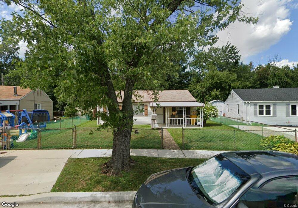
1610 Manning Rd Glen Burnie, MD 21061
Estimated Value: $275,416 - $323,000
--
Bed
1
Bath
988
Sq Ft
$311/Sq Ft
Est. Value
About This Home
This home is located at 1610 Manning Rd, Glen Burnie, MD 21061 and is currently estimated at $307,104, approximately $310 per square foot. 1610 Manning Rd is a home located in Anne Arundel County with nearby schools including Woodside Elementary School, Corkran Middle School, and Glen Burnie High School.
Ownership History
Date
Name
Owned For
Owner Type
Purchase Details
Closed on
Jun 26, 2025
Sold by
Mitchell Michael W
Bought by
Mitchell Michael W and Burnham Sherry A
Current Estimated Value
Purchase Details
Closed on
Oct 4, 2018
Sold by
Sheppard Richard L and Smith Debra M
Bought by
Mitchell Michael W
Home Financials for this Owner
Home Financials are based on the most recent Mortgage that was taken out on this home.
Original Mortgage
$184,594
Interest Rate
4.87%
Mortgage Type
FHA
Create a Home Valuation Report for This Property
The Home Valuation Report is an in-depth analysis detailing your home's value as well as a comparison with similar homes in the area
Home Values in the Area
Average Home Value in this Area
Purchase History
| Date | Buyer | Sale Price | Title Company |
|---|---|---|---|
| Mitchell Michael W | -- | None Listed On Document | |
| Mitchell Michael W | -- | None Listed On Document | |
| Mitchell Michael W | $188,000 | Perfection Title Ltd |
Source: Public Records
Mortgage History
| Date | Status | Borrower | Loan Amount |
|---|---|---|---|
| Previous Owner | Mitchell Michael W | $184,594 |
Source: Public Records
Tax History Compared to Growth
Tax History
| Year | Tax Paid | Tax Assessment Tax Assessment Total Assessment is a certain percentage of the fair market value that is determined by local assessors to be the total taxable value of land and additions on the property. | Land | Improvement |
|---|---|---|---|---|
| 2025 | $2,592 | $221,300 | $142,000 | $79,300 |
| 2024 | $2,592 | $208,167 | $0 | $0 |
| 2023 | $2,506 | $195,033 | $0 | $0 |
| 2022 | $2,327 | $181,900 | $112,000 | $69,900 |
| 2021 | $4,579 | $177,933 | $0 | $0 |
| 2020 | $2,207 | $173,967 | $0 | $0 |
| 2019 | $2,167 | $170,000 | $102,000 | $68,000 |
| 2018 | $1,696 | $167,267 | $0 | $0 |
| 2017 | $1,580 | $164,533 | $0 | $0 |
| 2016 | -- | $161,800 | $0 | $0 |
| 2015 | -- | $154,333 | $0 | $0 |
| 2014 | -- | $146,867 | $0 | $0 |
Source: Public Records
Map
Nearby Homes
- 1701 Norfolk Rd
- 1612 Lorimer Rd
- 1702 Manning Rd
- 1613 Kimber Rd
- 1731 Saunders Way
- 1921 Norwich Rd
- 8918 Twin Ridge Dr
- 1909 Pagham Rd
- 8903 Jeff Mar Dr
- 8906 Jeff Mar Dr
- 1003 Lee Rd
- 405 Morningside Dr
- 0 Irene Dr
- 100 Sandsbury Ave
- 206 Sandsbury Ave
- 201 Nina Ct
- 180 Jessica Ln
- 301 Whitman Ct
- 822 Dale Rd
- 713 Cotter Rd
- 1608 Manning Rd
- 1612 Manning Rd
- 1606 Manning Rd
- 1614 Manning Rd
- 1609 Manning Rd
- 1607 Manning Rd
- 1611 Manning Rd
- 1616 Manning Rd
- 1613 Manning Rd
- 1602 Manning Rd
- 1706 Norfolk Rd
- 1708 Norfolk Rd
- 1618 Manning Rd
- 1600 Lorimer Rd
- 1615 Manning Rd
- 1710 Norfolk Rd
- 1602 Lorimer Rd
- 1600 Manning Rd
- 1617 Manning Rd
- 1604 Lorimer Rd