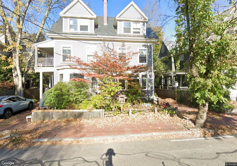
165 Upland Rd Cambridge, MA 02140
Neighborhood Nine NeighborhoodEstimated Value: $1,779,000 - $2,080,000
6
Beds
5
Baths
2,407
Sq Ft
$806/Sq Ft
Est. Value
About This Home
This home is located at 165 Upland Rd, Cambridge, MA 02140 and is currently estimated at $1,940,923, approximately $806 per square foot. 165 Upland Rd is a home located in Middlesex County with nearby schools including Cambridge Montessori School, Cambridge Friends School, and St Peter School.
Ownership History
Date
Name
Owned For
Owner Type
Purchase Details
Closed on
Nov 3, 1992
Sold by
Mallows Anthony D and Mallows Mary C
Bought by
Kendall Stephen P and Orcutt Georgia E
Current Estimated Value
Purchase Details
Closed on
Jan 23, 1990
Sold by
Pierce Olive R
Bought by
Mallows Anthony D N
Create a Home Valuation Report for This Property
The Home Valuation Report is an in-depth analysis detailing your home's value as well as a comparison with similar homes in the area
Home Values in the Area
Average Home Value in this Area
Purchase History
| Date | Buyer | Sale Price | Title Company |
|---|---|---|---|
| Kendall Stephen P | $385,000 | -- | |
| Mallows Anthony D N | $390,000 | -- |
Source: Public Records
Mortgage History
| Date | Status | Borrower | Loan Amount |
|---|---|---|---|
| Open | Mallows Anthony D N | $221,500 | |
| Closed | Mallows Anthony D N | $275,000 | |
| Closed | Mallows Anthony D N | $27,500 |
Source: Public Records
Tax History Compared to Growth
Tax History
| Year | Tax Paid | Tax Assessment Tax Assessment Total Assessment is a certain percentage of the fair market value that is determined by local assessors to be the total taxable value of land and additions on the property. | Land | Improvement |
|---|---|---|---|---|
| 2025 | $10,166 | $1,600,900 | $581,000 | $1,019,900 |
| 2024 | $9,442 | $1,595,000 | $612,700 | $982,300 |
| 2023 | $8,619 | $1,470,900 | $608,600 | $862,300 |
| 2022 | $8,330 | $1,407,100 | $627,500 | $779,600 |
| 2021 | $7,905 | $1,351,300 | $600,700 | $750,600 |
| 2020 | $7,808 | $1,357,900 | $620,900 | $737,000 |
| 2019 | $7,802 | $1,313,400 | $618,200 | $695,200 |
| 2018 | $7,487 | $1,190,300 | $544,300 | $646,000 |
| 2017 | $7,439 | $1,146,200 | $533,400 | $612,800 |
| 2016 | $7,494 | $1,072,100 | $500,600 | $571,500 |
| 2015 | $7,407 | $947,200 | $437,700 | $509,500 |
| 2014 | $7,048 | $841,000 | $382,900 | $458,100 |
Source: Public Records
Map
Nearby Homes
- 70 Walden St Unit 1
- 70 Walden St Unit 7
- 70 Walden St Unit 11
- 86 Avon Hill St
- 24 Cambridge Terrace Unit 2
- 43 Linnaean St Unit 42
- 1 Richdale Ave Unit 2
- 22 Agassiz St
- 273 Walden St Unit 2
- 8 Cogswell Ave
- 84 Garden St
- 3 Arlington St Unit 52
- 12-14 Gray Gardens W
- 12 Rindge Ave Unit 1
- 18 Donnell St
- 61 Bolton St Unit 304
- 148 Huron Ave
- 7 Beech St Unit 319
- 7 Beech St Unit 211
- 202 Garden St
- 167 Upland Rd
- 4 Vincent St
- 159 Upland Rd
- 3 Whittier St
- 169 Upland Rd Unit 3
- 169 Upland Rd Unit 2
- 169 Upland Rd Unit 1
- 3 Whittier St Unit 4
- 12 Vincent St
- 11 Whittier St
- 11 Whittier St Unit 11
- 9 Whittier St Unit 2
- 9 Whittier St Unit 2 rear
- 9 Whittier St
- 11 Whittier St Unit 1
- 16 Vincent St
- 16 Vincent St Unit 1
- 16 Vincent St Unit 2
- 153 Upland Rd
- 153 Upland Rd