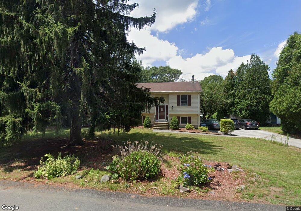
165 Woodside Ave Cumberland, RI 02864
Monastery Heights NeighborhoodEstimated Value: $495,000 - $631,000
3
Beds
3
Baths
1,748
Sq Ft
$337/Sq Ft
Est. Value
About This Home
This home is located at 165 Woodside Ave, Cumberland, RI 02864 and is currently estimated at $589,117, approximately $337 per square foot. 165 Woodside Ave is a home located in Providence County with nearby schools including Garvin Memorial School, Joseph L. McCourt Middle School, and Cumberland High School.
Ownership History
Date
Name
Owned For
Owner Type
Purchase Details
Closed on
Nov 8, 2019
Sold by
Mildner Donald M and Mildner Tracy
Bought by
Mildner Ft 2019
Current Estimated Value
Purchase Details
Closed on
Aug 15, 2001
Sold by
Lapointe Scott R and Lapointe Nancy E
Bought by
Mildner Donald M and Mildner Tracy
Purchase Details
Closed on
Jan 27, 1995
Sold by
Barnes Alan M and Barnes Deborah
Bought by
Lapointe Scott R and Lapointe Nancy
Create a Home Valuation Report for This Property
The Home Valuation Report is an in-depth analysis detailing your home's value as well as a comparison with similar homes in the area
Home Values in the Area
Average Home Value in this Area
Purchase History
| Date | Buyer | Sale Price | Title Company |
|---|---|---|---|
| Mildner Ft 2019 | -- | -- | |
| Mildner Donald M | $215,000 | -- | |
| Lapointe Scott R | $155,000 | -- |
Source: Public Records
Mortgage History
| Date | Status | Borrower | Loan Amount |
|---|---|---|---|
| Previous Owner | Lapointe Scott R | $54,800 | |
| Previous Owner | Lapointe Scott R | $251,250 |
Source: Public Records
Tax History Compared to Growth
Tax History
| Year | Tax Paid | Tax Assessment Tax Assessment Total Assessment is a certain percentage of the fair market value that is determined by local assessors to be the total taxable value of land and additions on the property. | Land | Improvement |
|---|---|---|---|---|
| 2025 | $5,569 | $453,900 | $160,700 | $293,200 |
| 2024 | $5,424 | $453,900 | $160,700 | $293,200 |
| 2023 | $5,274 | $453,900 | $160,700 | $293,200 |
| 2022 | $5,390 | $359,600 | $127,000 | $232,600 |
| 2021 | $5,301 | $359,600 | $127,000 | $232,600 |
| 2020 | $5,149 | $359,600 | $127,000 | $232,600 |
| 2019 | $5,261 | $331,300 | $108,200 | $223,100 |
| 2018 | $5,109 | $331,300 | $108,200 | $223,100 |
| 2017 | $5,039 | $331,300 | $108,200 | $223,100 |
| 2016 | $4,564 | $267,200 | $108,200 | $159,000 |
| 2015 | $4,564 | $267,200 | $108,200 | $159,000 |
| 2014 | $4,564 | $267,200 | $108,200 | $159,000 |
| 2013 | $4,589 | $290,800 | $108,200 | $182,600 |
Source: Public Records
Map
Nearby Homes
- 163 Woodside Ave
- 48 Pocasset Ave
- 73 Grandview Dr
- 24 Hamilton St
- 98 Iroquois Rd
- 226 Marshall Ave
- 457 Bryant St
- 73 Woodland St
- 38 Chestnut St
- 1551 Diamond Hill Rd
- 33 Valley St
- 34 Goddard St
- 153 Morris St
- 66 Pequot Ave
- 73 Vineyard Ave
- 300 England St
- 143 Waumsett Ave
- 24 Vineyard Ave
- 16 Kent St
- 44 Marshall Ave
- 187 Woodside Ave
- 70 Brookdale St
- 151 Woodside Ave
- 199 Woodside Ave
- 188 Woodside Ave
- 180 Woodside Ave
- 178 Woodside Ave
- 210 Woodside Ave
- 44 Brookdale St
- 94 Brookdale St
- 139 Woodside Ave
- 166 Woodside Ave
- 211 Woodside Ave
- 212 Woodside Ave
- 69 Brookdale St
- 57 Brookdale St
- 216 Woodside Ave
- 160 Woodside Ave
- 34 Brookdale St
- 129 Woodside Ave