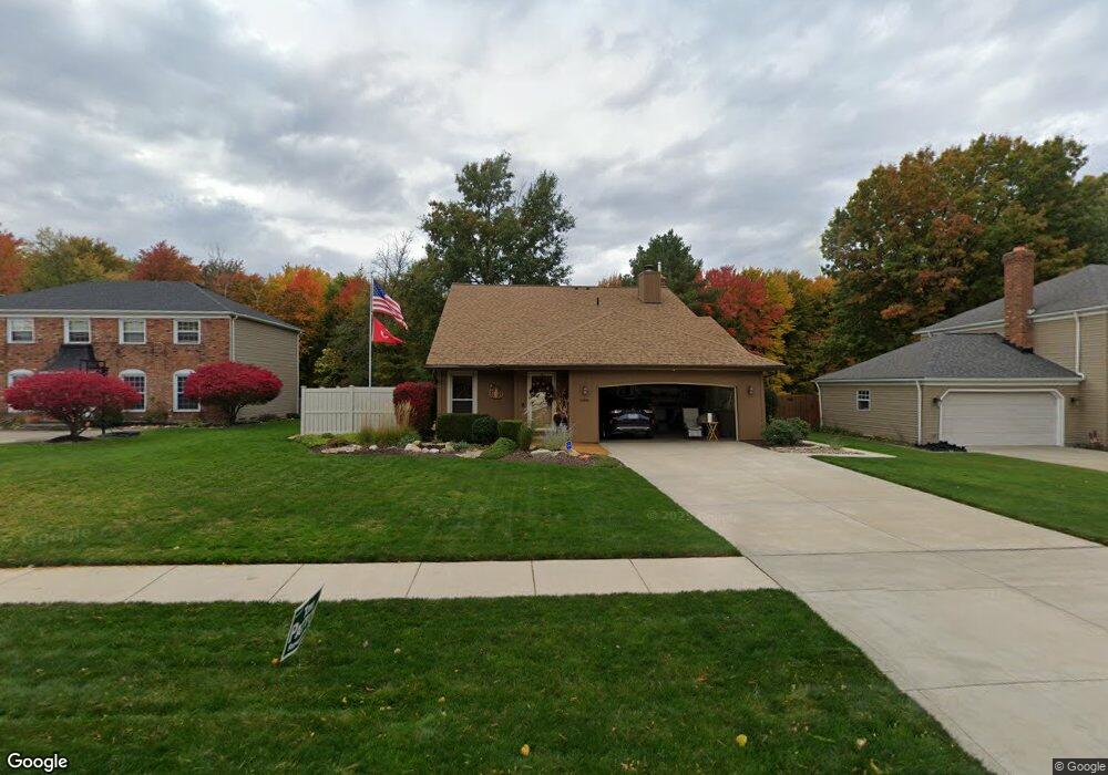
16935 Deer Path Dr Strongsville, OH 44136
Estimated Value: $341,625 - $379,000
3
Beds
3
Baths
2,043
Sq Ft
$176/Sq Ft
Est. Value
About This Home
This home is located at 16935 Deer Path Dr, Strongsville, OH 44136 and is currently estimated at $358,906, approximately $175 per square foot. 16935 Deer Path Dr is a home located in Cuyahoga County with nearby schools including Strongsville High School and Sts Joseph & John Interparochial School.
Ownership History
Date
Name
Owned For
Owner Type
Purchase Details
Closed on
Dec 3, 2013
Sold by
Petrowski Jeffrey J and Petrowski Sharon A
Bought by
Petrowski Jeff E
Current Estimated Value
Purchase Details
Closed on
Jan 19, 1977
Sold by
Petrowski Jeffrey J
Bought by
Petrowski Jeffrey J
Purchase Details
Closed on
Aug 10, 1976
Bought by
Petrowski Jeffrey J
Purchase Details
Closed on
Apr 22, 1976
Bought by
Production Homes Inc
Purchase Details
Closed on
Jan 1, 1976
Bought by
Erie Shores Dev Co Inc
Create a Home Valuation Report for This Property
The Home Valuation Report is an in-depth analysis detailing your home's value as well as a comparison with similar homes in the area
Home Values in the Area
Average Home Value in this Area
Purchase History
| Date | Buyer | Sale Price | Title Company |
|---|---|---|---|
| Petrowski Jeff E | -- | Attorney | |
| Petrowski Jeffrey J | -- | -- | |
| Petrowski Jeffrey J | $64,600 | -- | |
| Production Homes Inc | $17,000 | -- | |
| Erie Shores Dev Co Inc | -- | -- |
Source: Public Records
Tax History Compared to Growth
Tax History
| Year | Tax Paid | Tax Assessment Tax Assessment Total Assessment is a certain percentage of the fair market value that is determined by local assessors to be the total taxable value of land and additions on the property. | Land | Improvement |
|---|---|---|---|---|
| 2024 | $5,045 | $107,450 | $22,260 | $85,190 |
| 2023 | $5,203 | $83,100 | $18,800 | $64,300 |
| 2022 | $5,166 | $83,090 | $18,800 | $64,300 |
| 2021 | $5,125 | $83,090 | $18,800 | $64,300 |
| 2020 | $4,748 | $68,110 | $15,400 | $52,710 |
| 2019 | $4,609 | $194,600 | $44,000 | $150,600 |
| 2018 | $4,133 | $68,110 | $15,400 | $52,710 |
| 2017 | $4,159 | $62,690 | $12,430 | $50,260 |
| 2016 | $4,125 | $62,690 | $12,430 | $50,260 |
| 2015 | -- | $62,690 | $12,430 | $50,260 |
| 2014 | -- | $62,690 | $12,430 | $50,260 |
Source: Public Records
Map
Nearby Homes
- 18294 Drake Rd
- 17934 Cambridge Oval
- 17024 Bear Creek Ln
- 17682 Drake Rd
- 18411 Yorktown Oval
- 17259 Woodshire Dr
- 19297 Lauren Way
- 17159 Turkey Meadow Ln
- 18162 Fawn Cir
- 19311 Bradford Ct
- 18848 Pearl Rd
- 20393 Wildwood Ln
- 16650 Lanier Ave
- 16486 S Red Rock Dr
- 18630 Shurmer Rd
- 20114 Drake Rd
- 19908 Stoughton Dr
- 20121 Driftwood Ct
- 17130 Golden Star Dr
- 16711 Beech Cir
- 16937 Deer Path Dr
- 16933 Deer Path Dr
- 16931 Deer Path Dr
- 16939 Deer Path Dr
- 16928 Deer Path Dr
- 16930 Deer Path Dr
- 16929 Deer Path Dr
- 16926 Deer Path Dr
- 16941 Deer Path Dr
- 16932 Deer Path Dr
- 17180 Hawks Lookout Ln
- 16934 Deer Path Dr
- 16927 Deer Path Dr
- 16943 Deer Path Dr
- 17172 Hawks Lookout Ln
- 16936 Deer Path Dr
- 16925 Deer Path Dr
- 16913 Rabbit Run Dr
- 16945 Deer Path Dr
- 16905 Rabbit Run Dr