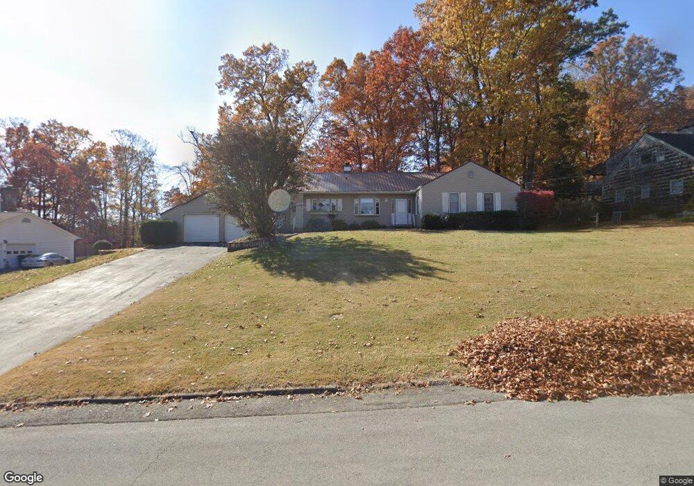
1711 Brentwood Dr Greeneville, TN 37743
Estimated Value: $302,864 - $352,000
3
Beds
2
Baths
1,943
Sq Ft
$171/Sq Ft
Est. Value
About This Home
This home is located at 1711 Brentwood Dr, Greeneville, TN 37743 and is currently estimated at $333,216, approximately $171 per square foot. 1711 Brentwood Dr is a home located in Greene County with nearby schools including Greeneville Middle School, Greeneville High School, and Towering Oaks Christian School.
Ownership History
Date
Name
Owned For
Owner Type
Purchase Details
Closed on
Oct 14, 2005
Sold by
Durham Phillip G
Bought by
Dagnall George C
Current Estimated Value
Purchase Details
Closed on
Jan 18, 2005
Sold by
Durham Lisa G
Bought by
Durham Phillip G
Home Financials for this Owner
Home Financials are based on the most recent Mortgage that was taken out on this home.
Original Mortgage
$179,000
Interest Rate
5.61%
Purchase Details
Closed on
Dec 22, 1999
Bought by
Welch Lisa G
Purchase Details
Closed on
Oct 14, 1997
Sold by
Deheus Beatrice
Bought by
Roy Andrea
Create a Home Valuation Report for This Property
The Home Valuation Report is an in-depth analysis detailing your home's value as well as a comparison with similar homes in the area
Home Values in the Area
Average Home Value in this Area
Purchase History
| Date | Buyer | Sale Price | Title Company |
|---|---|---|---|
| Dagnall George C | $182,000 | -- | |
| Durham Phillip G | -- | -- | |
| Welch Lisa G | $147,000 | -- | |
| Roy Andrea | $140,000 | -- |
Source: Public Records
Mortgage History
| Date | Status | Borrower | Loan Amount |
|---|---|---|---|
| Previous Owner | Roy Andrea | $179,000 |
Source: Public Records
Tax History Compared to Growth
Tax History
| Year | Tax Paid | Tax Assessment Tax Assessment Total Assessment is a certain percentage of the fair market value that is determined by local assessors to be the total taxable value of land and additions on the property. | Land | Improvement |
|---|---|---|---|---|
| 2024 | $2,166 | $66,025 | $7,350 | $58,675 |
| 2023 | $2,254 | $66,025 | $0 | $0 |
| 2022 | $1,493 | $35,875 | $6,950 | $28,925 |
| 2021 | $1,493 | $35,875 | $6,950 | $28,925 |
| 2020 | $1,493 | $35,875 | $6,950 | $28,925 |
| 2019 | $1,493 | $35,875 | $6,950 | $28,925 |
| 2018 | $1,447 | $35,875 | $6,950 | $28,925 |
| 2017 | $1,497 | $37,650 | $6,950 | $30,700 |
| 2016 | $1,459 | $37,650 | $6,950 | $30,700 |
| 2015 | $1,460 | $37,650 | $6,950 | $30,700 |
| 2014 | $1,396 | $37,650 | $6,950 | $30,700 |
Source: Public Records
Map
Nearby Homes
- 1700 Brentwood Dr
- 126 Maple Crest
- L23r Maple Crest
- L24r Maple Crest
- 1814 Brentwood Dr
- 136 Maple Crest
- 1600 Brentwood Dr
- 108 Alpine Cir
- 1431 E Church St
- 1403 Brentwood Dr
- 1238 Tanglewood Dr
- 103 Edgewood Dr
- 111 Wayfair Dr
- 1210 Tanglewood Dr
- 40 Hillside Ct
- 115 York Dr
- 300 Pinecrest Dr
- 1216 Upland Ave
- 71 Goddard Dr
- 508 Meadowlark Dr
- 1709 Brentwood Dr
- 1801 Brentwood Dr
- 108 Parkwood Cir
- 110 Parkwood Cir
- 1718 Brentwood Dr
- 1716 Brentwood Dr
- 1803 Brentwood Dr
- 1707 Brentwood Dr
- 1714 Brentwood Dr
- 1805 Brentwood Dr
- 115 Stratford Dr
- 106 Parkwood Cir
- 1705 Brentwood Dr
- 1804 Brentwood Dr
- 112 Parkwood Cir
- 1703 Brentwood Dr
- 1806 Brentwood Dr Unit 1
- 114 Stratford Dr
- 1811 Brentwood Dr
- 1712 Brentwood Dr