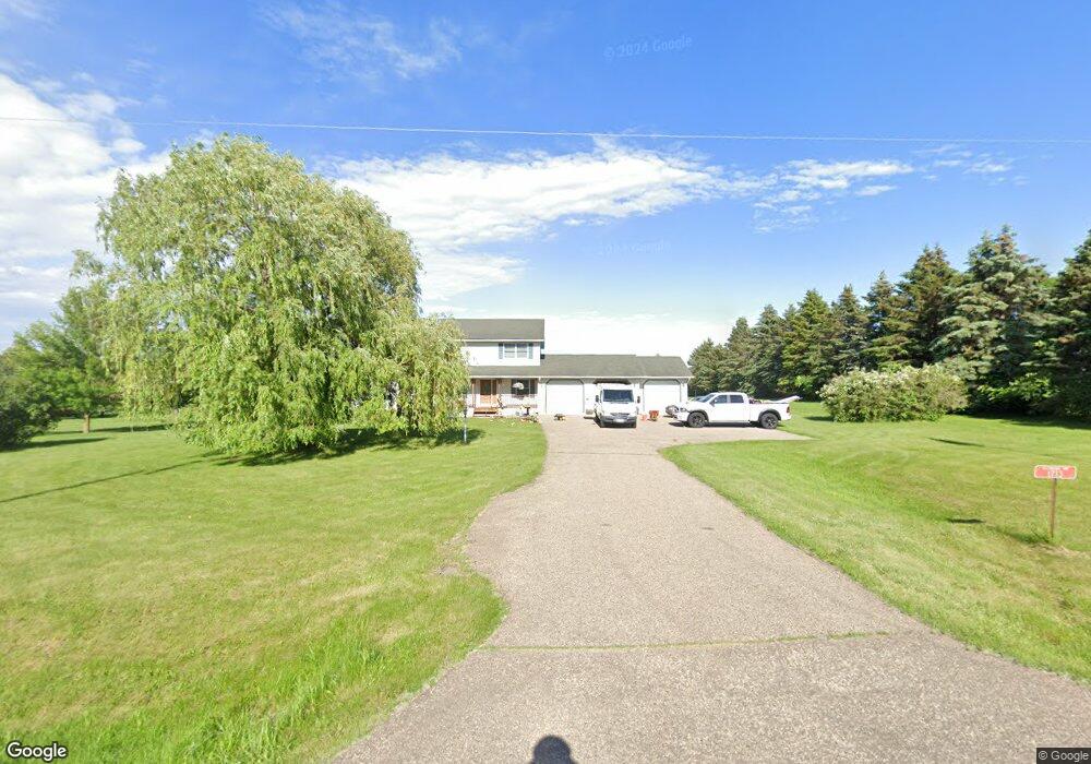
1713 112th St New Richmond, WI 54017
Richmond NeighborhoodEstimated Value: $461,000 - $519,000
3
Beds
3
Baths
2,184
Sq Ft
$223/Sq Ft
Est. Value
About This Home
This home is located at 1713 112th St, New Richmond, WI 54017 and is currently estimated at $487,553, approximately $223 per square foot. 1713 112th St is a home located in St. Croix County with nearby schools including New Richmond High School and St. Mary School.
Ownership History
Date
Name
Owned For
Owner Type
Purchase Details
Closed on
Aug 2, 2019
Sold by
Ince Jacque
Bought by
Wolf Jacob
Current Estimated Value
Home Financials for this Owner
Home Financials are based on the most recent Mortgage that was taken out on this home.
Original Mortgage
$287,920
Outstanding Balance
$252,165
Interest Rate
3.7%
Mortgage Type
New Conventional
Estimated Equity
$235,388
Purchase Details
Closed on
Mar 27, 2019
Sold by
Smith Calsey and Ince Calsey
Bought by
Ince Jacque
Purchase Details
Closed on
May 16, 2018
Sold by
Jansen Earl E and Jansen Debra J
Bought by
Ince Jacque and Smith Calsey
Home Financials for this Owner
Home Financials are based on the most recent Mortgage that was taken out on this home.
Original Mortgage
$31,000
Interest Rate
4.4%
Mortgage Type
New Conventional
Create a Home Valuation Report for This Property
The Home Valuation Report is an in-depth analysis detailing your home's value as well as a comparison with similar homes in the area
Home Values in the Area
Average Home Value in this Area
Purchase History
| Date | Buyer | Sale Price | Title Company |
|---|---|---|---|
| Wolf Jacob | $359,900 | Stewart Title | |
| Ince Jacque | -- | None Available | |
| Ince Jacque | $365,000 | Absolute Title |
Source: Public Records
Mortgage History
| Date | Status | Borrower | Loan Amount |
|---|---|---|---|
| Open | Wolf Jacob | $287,920 | |
| Previous Owner | Ince Jacque | $31,000 |
Source: Public Records
Tax History Compared to Growth
Tax History
| Year | Tax Paid | Tax Assessment Tax Assessment Total Assessment is a certain percentage of the fair market value that is determined by local assessors to be the total taxable value of land and additions on the property. | Land | Improvement |
|---|---|---|---|---|
| 2024 | $51 | $413,000 | $44,400 | $368,600 |
| 2023 | $4,774 | $413,000 | $44,400 | $368,600 |
| 2022 | $4,148 | $413,000 | $44,400 | $368,600 |
| 2021 | $4,178 | $413,000 | $44,400 | $368,600 |
| 2020 | $4,593 | $264,900 | $25,200 | $239,700 |
| 2019 | $4,459 | $264,900 | $25,200 | $239,700 |
| 2018 | $4,322 | $264,900 | $25,200 | $239,700 |
| 2017 | $4,210 | $264,900 | $25,200 | $239,700 |
| 2016 | $4,210 | $264,900 | $25,200 | $239,700 |
| 2015 | $4,387 | $264,900 | $25,200 | $239,700 |
| 2014 | $4,229 | $264,900 | $25,200 | $239,700 |
| 2013 | $3,774 | $247,900 | $25,200 | $222,700 |
Source: Public Records
Map
Nearby Homes
- 1418 Bluff Border Rd
- 1176 Carroll St
- 1705 107th St
- 1561 Creekwood Dr
- 1549 Creekwood Dr
- 1539 Creekwood Dr
- 1513 Creekwood Dr
- Kenny Plan at The Creek at Gloverdale
- Nora Plan at The Creek at Gloverdale
- Hudson Plan at The Creek at Gloverdale
- Aspen Plan at The Creek at Gloverdale
- Alder Plan at The Creek at Gloverdale
- Riley Plan at The Creek at Gloverdale
- Ashlyn Plan at The Creek at Gloverdale
- Sutherland Plan at The Creek at Gloverdale
- Victoria Plan at The Creek at Gloverdale
- Kendall Plan at The Creek at Gloverdale
- Sully Plan at The Creek at Gloverdale
- 1517 Creekwood Dr
- TBD County Road A