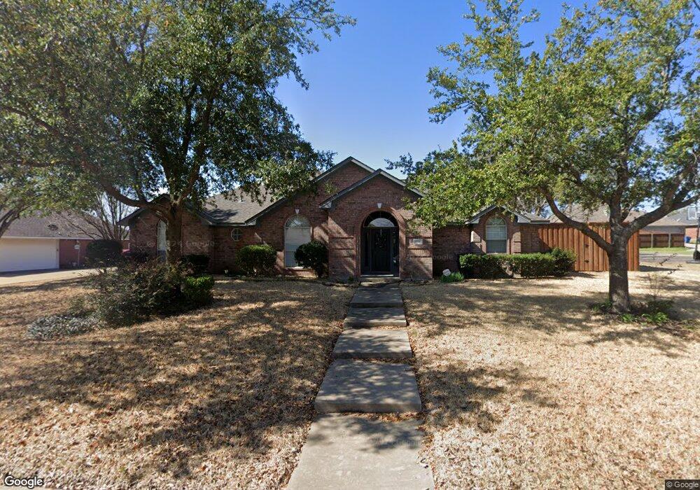
1721 Bowie Cir Corsicana, TX 75110
Estimated Value: $283,000 - $359,000
3
Beds
3
Baths
2,044
Sq Ft
$160/Sq Ft
Est. Value
About This Home
This home is located at 1721 Bowie Cir, Corsicana, TX 75110 and is currently estimated at $327,662, approximately $160 per square foot. 1721 Bowie Cir is a home located in Navarro County with nearby schools including Corsicana High School and William Tyndale Christian Academy.
Ownership History
Date
Name
Owned For
Owner Type
Purchase Details
Closed on
Sep 28, 2016
Sold by
Carter Debra Dawn
Bought by
Eubank Michael J and Eubank Chalamette
Current Estimated Value
Home Financials for this Owner
Home Financials are based on the most recent Mortgage that was taken out on this home.
Original Mortgage
$110,000
Outstanding Balance
$69,631
Interest Rate
3.43%
Mortgage Type
New Conventional
Estimated Equity
$258,031
Purchase Details
Closed on
Nov 11, 2013
Sold by
Carter Kenneth Herman
Bought by
Carter Debra Dawn
Purchase Details
Closed on
Dec 2, 2009
Sold by
Golden Joe D
Bought by
Carter Kenneth and Carter Debra
Home Financials for this Owner
Home Financials are based on the most recent Mortgage that was taken out on this home.
Original Mortgage
$156,120
Interest Rate
4.99%
Mortgage Type
FHA
Create a Home Valuation Report for This Property
The Home Valuation Report is an in-depth analysis detailing your home's value as well as a comparison with similar homes in the area
Home Values in the Area
Average Home Value in this Area
Purchase History
| Date | Buyer | Sale Price | Title Company |
|---|---|---|---|
| Eubank Michael J | -- | Chicago Title | |
| Carter Debra Dawn | -- | None Available | |
| Carter Kenneth | -- | -- |
Source: Public Records
Mortgage History
| Date | Status | Borrower | Loan Amount |
|---|---|---|---|
| Open | Eubank Michael J | $110,000 | |
| Previous Owner | Carter Kenneth | $156,120 |
Source: Public Records
Tax History Compared to Growth
Tax History
| Year | Tax Paid | Tax Assessment Tax Assessment Total Assessment is a certain percentage of the fair market value that is determined by local assessors to be the total taxable value of land and additions on the property. | Land | Improvement |
|---|---|---|---|---|
| 2025 | $6,545 | $345,630 | $44,360 | $301,270 |
| 2024 | $6,823 | $360,350 | $40,950 | $319,400 |
| 2023 | $6,605 | $357,820 | $40,950 | $316,870 |
| 2022 | $4,858 | $209,800 | $17,060 | $192,740 |
| 2021 | $4,585 | $176,370 | $17,060 | $159,310 |
| 2020 | $4,680 | $176,370 | $17,060 | $159,310 |
| 2019 | $4,659 | $169,630 | $17,060 | $152,570 |
| 2018 | $4,654 | $169,480 | $13,650 | $155,830 |
| 2017 | $4,144 | $151,070 | $13,650 | $137,420 |
| 2016 | $4,554 | $166,030 | $13,650 | $152,380 |
| 2015 | -- | $166,030 | $13,650 | $152,380 |
| 2014 | -- | $166,030 | $13,650 | $152,380 |
Source: Public Records
Map
Nearby Homes
- 1500 Bowie Cir
- 1305 Tammy Ave
- 3100 Louis Ave
- TBD Emhouse
- 1004 Bryn Mawr St
- 309 Fairway Dr
- 1000 Bryn Mawr St
- 524 Lakewood Ave
- 713 Meadow Dr
- 2604 Forest Lane Cir
- 3400 Dobbins Row
- 542 Forrest Ln
- 2110 Dartmouth Ln
- 2631 Fish Tank Rd
- 2629 Fish Tank Rd
- 421 Forrest Ln
- 2809 Lafayette St
- 3128 Emhouse Rd
- 1906 Mimosa Dr
- 408 Fairmont Ave
- 1717 Bowie Cir
- 1800 Clearbrook Ln
- 1804 Clearbrook Ln
- 1725 Bowie Cir
- 1738 Clearbrook Ln
- 1720 Bowie Cir
- 1808 Clearbrook Ln
- 1713 Bowie Cir
- 1812 Clearbrook Ln
- 1716 Bowie Cir
- TBD Clearbrook Ln
- 1816 Clearbrook Ln
- 1726 Clearbrook Ln
- 1801 Clearbrook Ln
- 000 Clearbrook Ln
- 0 Brook Rd Unit 13212999
- 1712 Bowie Cir
- 1600 Northwood Blvd
- 1709 Bowie Cir
- 1805 Clearbrook Ln