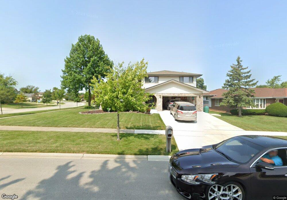
17732 Oakwood Dr Tinley Park, IL 60487
Central Tinley Park NeighborhoodEstimated Value: $438,000 - $497,000
4
Beds
2
Baths
2,697
Sq Ft
$171/Sq Ft
Est. Value
About This Home
This home is located at 17732 Oakwood Dr, Tinley Park, IL 60487 and is currently estimated at $462,418, approximately $171 per square foot. 17732 Oakwood Dr is a home located in Cook County with nearby schools including Christa Mcauliffe School, Prairie View Middle School, and Victor J Andrew High School.
Ownership History
Date
Name
Owned For
Owner Type
Purchase Details
Closed on
Apr 13, 2016
Sold by
Bidny Stefhn W and Bidny Grace A
Bought by
Bidny Stefan W and Bidny Grace A
Current Estimated Value
Purchase Details
Closed on
Jan 23, 1998
Sold by
Klaric John A and Klaric Debra L
Bought by
Bidny Stefan W and Bidny Grace A
Home Financials for this Owner
Home Financials are based on the most recent Mortgage that was taken out on this home.
Original Mortgage
$60,000
Interest Rate
7.16%
Create a Home Valuation Report for This Property
The Home Valuation Report is an in-depth analysis detailing your home's value as well as a comparison with similar homes in the area
Home Values in the Area
Average Home Value in this Area
Purchase History
| Date | Buyer | Sale Price | Title Company |
|---|---|---|---|
| Bidny Stefan W | -- | None Available | |
| Bidny Stefan W | $197,500 | -- |
Source: Public Records
Mortgage History
| Date | Status | Borrower | Loan Amount |
|---|---|---|---|
| Previous Owner | Bidny Stefan W | $60,000 |
Source: Public Records
Tax History Compared to Growth
Tax History
| Year | Tax Paid | Tax Assessment Tax Assessment Total Assessment is a certain percentage of the fair market value that is determined by local assessors to be the total taxable value of land and additions on the property. | Land | Improvement |
|---|---|---|---|---|
| 2024 | $9,195 | $39,086 | $5,589 | $33,497 |
| 2023 | $7,136 | $42,000 | $5,589 | $36,411 |
| 2022 | $7,136 | $29,268 | $4,860 | $24,408 |
| 2021 | $6,725 | $29,268 | $4,860 | $24,408 |
| 2020 | $8,345 | $31,035 | $4,860 | $26,175 |
| 2019 | $6,746 | $26,975 | $4,374 | $22,601 |
| 2018 | $6,599 | $26,975 | $4,374 | $22,601 |
| 2017 | $7,290 | $26,975 | $4,374 | $22,601 |
| 2016 | $7,296 | $24,466 | $3,888 | $20,578 |
| 2015 | $8,022 | $27,039 | $3,888 | $23,151 |
| 2014 | $7,971 | $27,039 | $3,888 | $23,151 |
| 2013 | $8,172 | $29,687 | $3,888 | $25,799 |
Source: Public Records
Map
Nearby Homes
- 17533 Pecan Ln
- 9280 Windsor Pkwy Unit 92
- 9260 Windsor Pkwy Unit 80
- 9201 175th St
- 17964 Upland Dr
- 17631 Dover Ct
- 18055 Upland Dr
- Fremont Plan at Radcliffe Place
- Calysta Plan at Radcliffe Place
- Danbury Plan at Radcliffe Place
- Briarcliffe Plan at Radcliffe Place
- Eden Plan at Radcliffe Place
- Amberwood Plan at Radcliffe Place
- 17535 S La Grange Rd
- 17535-2 Lagrange Rd
- 17230 Shetland Dr
- 9038 Mansfield Dr Unit 8
- 17324 Humber Ln
- 17224 Briar Dr
- 18248 Murphy Cir Unit 182
- 17726 Oakwood Dr
- 17720 Oakwood Dr
- 9043 178th St
- 17731 Oakwood Dr
- 9037 178th St
- 9047 178th St
- 17725 Oakwood Dr
- 17714 Oakwood Dr
- 9031 178th St
- 17801 Elmwood Dr
- 9025 178th St
- 9018 178th St
- 17713 Oakwood Dr
- 9036 Poplar St
- 9042 Poplar St
- 9024 Poplar St
- 9019 178th St
- 17807 Elmwood Dr
- 17800 Elmwood Dr
- 17707 Oakwood Dr