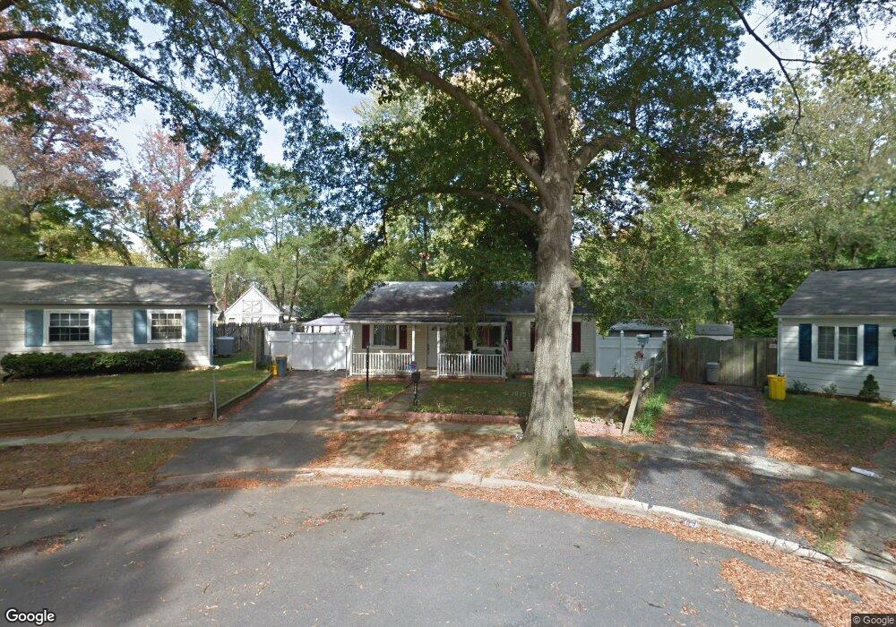
1810 Saunders Way Glen Burnie, MD 21061
Estimated Value: $312,000 - $346,000
--
Bed
1
Bath
1,204
Sq Ft
$278/Sq Ft
Est. Value
About This Home
This home is located at 1810 Saunders Way, Glen Burnie, MD 21061 and is currently estimated at $334,873, approximately $278 per square foot. 1810 Saunders Way is a home located in Anne Arundel County with nearby schools including Woodside Elementary School, Corkran Middle School, and Glen Burnie High School.
Ownership History
Date
Name
Owned For
Owner Type
Purchase Details
Closed on
Aug 22, 2005
Sold by
Kluczynski Jeffrey L
Bought by
Fortin Oscar and Fortin Dilcia
Current Estimated Value
Home Financials for this Owner
Home Financials are based on the most recent Mortgage that was taken out on this home.
Original Mortgage
$168,000
Outstanding Balance
$95,708
Interest Rate
7%
Mortgage Type
Adjustable Rate Mortgage/ARM
Estimated Equity
$239,165
Purchase Details
Closed on
Aug 23, 1999
Sold by
Bruce Paul J
Bought by
Kluczynski Jeffrey L
Purchase Details
Closed on
Sep 11, 1990
Sold by
Cogswell Paul G
Bought by
Bruce Paul J
Home Financials for this Owner
Home Financials are based on the most recent Mortgage that was taken out on this home.
Original Mortgage
$94,250
Interest Rate
10.19%
Create a Home Valuation Report for This Property
The Home Valuation Report is an in-depth analysis detailing your home's value as well as a comparison with similar homes in the area
Home Values in the Area
Average Home Value in this Area
Purchase History
| Date | Buyer | Sale Price | Title Company |
|---|---|---|---|
| Fortin Oscar | $210,000 | -- | |
| Kluczynski Jeffrey L | $100,000 | -- | |
| Bruce Paul J | $92,000 | -- |
Source: Public Records
Mortgage History
| Date | Status | Borrower | Loan Amount |
|---|---|---|---|
| Open | Fortin Oscar | $168,000 | |
| Closed | Fortin Oscar | $42,000 | |
| Previous Owner | Bruce Paul J | $94,250 |
Source: Public Records
Tax History Compared to Growth
Tax History
| Year | Tax Paid | Tax Assessment Tax Assessment Total Assessment is a certain percentage of the fair market value that is determined by local assessors to be the total taxable value of land and additions on the property. | Land | Improvement |
|---|---|---|---|---|
| 2025 | $2,736 | $255,900 | $144,800 | $111,100 |
| 2024 | $2,736 | $241,367 | $0 | $0 |
| 2023 | $2,647 | $226,833 | $0 | $0 |
| 2022 | $2,459 | $212,300 | $114,800 | $97,500 |
| 2021 | $4,839 | $207,900 | $0 | $0 |
| 2020 | $2,339 | $203,500 | $0 | $0 |
| 2019 | $2,302 | $199,100 | $104,800 | $94,300 |
| 2018 | $1,984 | $195,700 | $0 | $0 |
| 2017 | $2,176 | $192,300 | $0 | $0 |
| 2016 | -- | $188,900 | $0 | $0 |
| 2015 | -- | $183,000 | $0 | $0 |
| 2014 | -- | $177,100 | $0 | $0 |
Source: Public Records
Map
Nearby Homes
- 1701 Norfolk Rd
- 1731 Saunders Way
- 1702 Manning Rd
- 1921 Norwich Rd
- 1612 Lorimer Rd
- 1613 Kimber Rd
- 8918 Twin Ridge Dr
- 1909 Pagham Rd
- 8903 Jeff Mar Dr
- 8906 Jeff Mar Dr
- 100 Sandsbury Ave
- 206 Sandsbury Ave
- 405 Morningside Dr
- 1003 Lee Rd
- 180 Jessica Ln
- 0 Irene Dr
- 201 Nina Ct
- 7911 Ritchie Hwy
- 301 Whitman Ct
- 7818 Oakwood Rd
- 1808 Saunders Way
- 1812 Saunders Way
- 1806 Saunders Way
- 1703 Norfolk Rd
- 1817 Saunders Way
- 1705 Norfolk Rd
- 1815 Saunders Way
- 1804 Saunders Way
- 1813 Saunders Way
- 1811 Saunders Way
- 1707 Norfolk Rd
- 1802 Saunders Way
- 1600 Manning Rd
- 1809 Saunders Way
- 1706 Norfolk Rd
- 1800 Saunders Way
- 1807 Saunders Way
- 7880 Ritchie Hwy
- 1602 Manning Rd
- 1805 Saunders Way