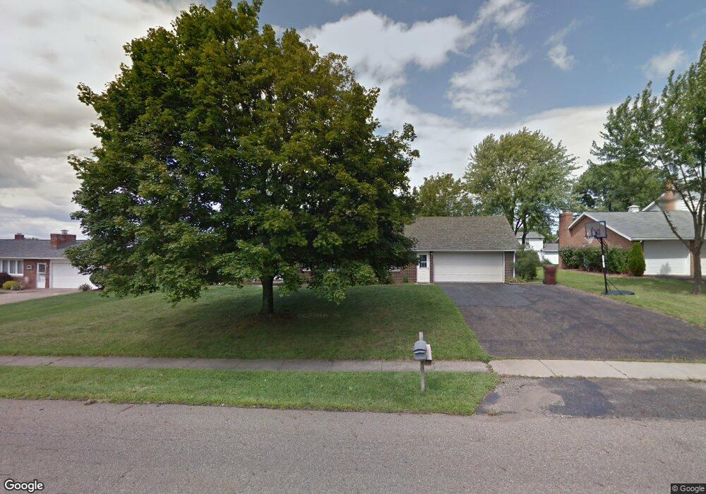
1837 Edmar St Louisville, OH 44641
Estimated Value: $252,376 - $287,000
4
Beds
2
Baths
2,100
Sq Ft
$129/Sq Ft
Est. Value
About This Home
This home is located at 1837 Edmar St, Louisville, OH 44641 and is currently estimated at $270,594, approximately $128 per square foot. 1837 Edmar St is a home located in Stark County with nearby schools including Louisville High School and St. Thomas Aquinas High School & Middle School.
Ownership History
Date
Name
Owned For
Owner Type
Purchase Details
Closed on
Aug 16, 2007
Sold by
Myers Dennis E and Myers Susan A
Bought by
Roberts Lee A
Current Estimated Value
Home Financials for this Owner
Home Financials are based on the most recent Mortgage that was taken out on this home.
Original Mortgage
$118,000
Outstanding Balance
$74,826
Interest Rate
6.69%
Mortgage Type
Purchase Money Mortgage
Estimated Equity
$195,768
Create a Home Valuation Report for This Property
The Home Valuation Report is an in-depth analysis detailing your home's value as well as a comparison with similar homes in the area
Home Values in the Area
Average Home Value in this Area
Purchase History
| Date | Buyer | Sale Price | Title Company |
|---|---|---|---|
| Roberts Lee A | $148,000 | None Available |
Source: Public Records
Mortgage History
| Date | Status | Borrower | Loan Amount |
|---|---|---|---|
| Open | Roberts Lee A | $118,000 |
Source: Public Records
Tax History Compared to Growth
Tax History
| Year | Tax Paid | Tax Assessment Tax Assessment Total Assessment is a certain percentage of the fair market value that is determined by local assessors to be the total taxable value of land and additions on the property. | Land | Improvement |
|---|---|---|---|---|
| 2025 | -- | $72,280 | $16,590 | $55,690 |
| 2024 | -- | $72,280 | $16,590 | $55,690 |
| 2023 | $2,151 | $59,220 | $15,680 | $43,540 |
| 2022 | $2,175 | $59,220 | $15,680 | $43,540 |
| 2021 | $2,181 | $59,220 | $15,680 | $43,540 |
| 2020 | $1,776 | $53,380 | $14,110 | $39,270 |
| 2019 | $1,783 | $55,550 | $13,790 | $41,760 |
| 2018 | $1,863 | $55,550 | $13,790 | $41,760 |
| 2017 | $1,678 | $49,420 | $12,110 | $37,310 |
| 2016 | $1,712 | $49,420 | $12,110 | $37,310 |
| 2015 | $1,717 | $49,420 | $12,110 | $37,310 |
| 2014 | $1,544 | $42,740 | $10,470 | $32,270 |
| 2013 | $776 | $42,740 | $10,470 | $32,270 |
Source: Public Records
Map
Nearby Homes
- 2110 Edmar St
- 1812 E Broad St
- 1715 High St
- 641 S Nickelplate St
- 3390 Meese Rd NE
- 520 S Silver St
- 308 Superior St
- 908 Sand Lot Cir
- 2015 E Main St
- 728 E Broad St
- 0 Michigan Blvd
- 510 S Bauman Ct
- 204 E Broad St
- 107 E Broad St
- 8225 Georgetown St
- 325 Lincoln Ave
- 1702 View Pointe Ave
- 1639 Horizon Dr
- 1170 Winding Ridge Ave
- 910 Crosswyck Cir