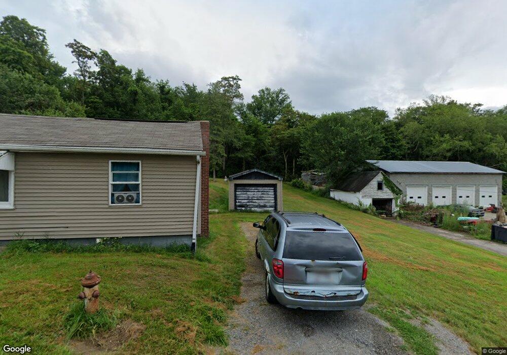
1850 La Croft Ave East Liverpool, OH 43920
Estimated Value: $51,000 - $102,000
2
Beds
1
Bath
560
Sq Ft
$125/Sq Ft
Est. Value
About This Home
This home is located at 1850 La Croft Ave, East Liverpool, OH 43920 and is currently estimated at $69,723, approximately $124 per square foot. 1850 La Croft Ave is a home with nearby schools including Westgate Middle School, LaCroft Elementary School, and East Liverpool High School.
Ownership History
Date
Name
Owned For
Owner Type
Purchase Details
Closed on
Jun 19, 2020
Bought by
Kwasnik Deloris J
Current Estimated Value
Purchase Details
Closed on
Jul 15, 1998
Sold by
Miraglata Philip S
Bought by
Kwasnik Richard P and Kwasnik Deloris J
Home Financials for this Owner
Home Financials are based on the most recent Mortgage that was taken out on this home.
Original Mortgage
$14,400
Interest Rate
7.03%
Purchase Details
Closed on
Jul 25, 1991
Bought by
Miraglata Philip S
Create a Home Valuation Report for This Property
The Home Valuation Report is an in-depth analysis detailing your home's value as well as a comparison with similar homes in the area
Home Values in the Area
Average Home Value in this Area
Purchase History
| Date | Buyer | Sale Price | Title Company |
|---|---|---|---|
| Kwasnik Deloris J | -- | -- | |
| Kwasnik Richard P | $18,000 | -- | |
| Miraglata Philip S | $15,900 | -- |
Source: Public Records
Mortgage History
| Date | Status | Borrower | Loan Amount |
|---|---|---|---|
| Previous Owner | Kwasnik Richard P | $14,400 |
Source: Public Records
Tax History Compared to Growth
Tax History
| Year | Tax Paid | Tax Assessment Tax Assessment Total Assessment is a certain percentage of the fair market value that is determined by local assessors to be the total taxable value of land and additions on the property. | Land | Improvement |
|---|---|---|---|---|
| 2024 | $486 | $11,620 | $490 | $11,130 |
| 2023 | $486 | $11,620 | $490 | $11,130 |
| 2022 | $486 | $11,620 | $490 | $11,130 |
| 2021 | $407 | $9,280 | $490 | $8,790 |
| 2020 | $407 | $9,280 | $490 | $8,790 |
| 2019 | $407 | $9,280 | $490 | $8,790 |
| 2018 | $394 | $8,440 | $460 | $7,980 |
| 2017 | $416 | $8,440 | $460 | $7,980 |
| 2016 | $415 | $7,140 | $490 | $6,650 |
| 2015 | $356 | $7,140 | $490 | $6,650 |
| 2014 | $330 | $7,140 | $490 | $6,650 |
Source: Public Records
Map
Nearby Homes
- 118 S Shadylane Dr
- 504 Williams Ave
- 106 N Surry Rd
- 564 Williams Ave
- 1874 Idaho Ave
- 468 6th Ave
- 2249 Lisbon St
- 539 7th Ave
- 2476 Lisbon St
- 2512 Boring Ln
- 602 9th Ave
- 1183 Lisbon St
- 0 Kingsridge Rd
- 1250 Northside St
- 1209 Northside St
- 967 7th Ave
- 139 Huntington Ct
- 1332 Sunnyside St
- 138 Huntington Ct
- 141 Huntington Ct
- 1874 La Croft Ave
- 1830 La Croft Ave
- 1831 La Croft Ave
- 1831 La Croft Ave
- 1839 La Croft Ave
- 1888 La Croft Ave
- 1887 La Croft Ave
- 1821 La Croft Ave
- 1906 La Croft Ave
- 1905 La Croft Ave
- 375 1st Ave
- 1781 La Croft Ave
- 457 1st Ave Unit 459
- 1920 La Croft Ave
- 1906 Park Place Ave
- 1991 Lisbon St
- 1917 La Croft Ave
- 497 1st Ave
- 499 1st Ave
- 2001 Lisbon St