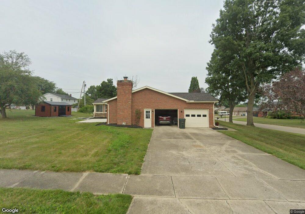
1856 Opal St Louisville, OH 44641
Estimated Value: $286,165 - $334,000
3
Beds
4
Baths
2,250
Sq Ft
$136/Sq Ft
Est. Value
About This Home
This home is located at 1856 Opal St, Louisville, OH 44641 and is currently estimated at $306,041, approximately $136 per square foot. 1856 Opal St is a home located in Stark County with nearby schools including Louisville High School and St. Thomas Aquinas High School & Middle School.
Ownership History
Date
Name
Owned For
Owner Type
Purchase Details
Closed on
Aug 22, 2025
Sold by
Urick Michael J and Urick Maria L
Bought by
Michael J Urick And Maria L Urick Revocable T and Urick
Current Estimated Value
Purchase Details
Closed on
May 14, 2007
Sold by
Atkins Lisa L and Urick Lisa L
Bought by
Urick Michael J
Home Financials for this Owner
Home Financials are based on the most recent Mortgage that was taken out on this home.
Original Mortgage
$173,565
Interest Rate
6.2%
Mortgage Type
FHA
Purchase Details
Closed on
Aug 3, 2001
Sold by
Myers William L and Myers Christine A
Bought by
Urick Michael J and Urick Lisa L
Home Financials for this Owner
Home Financials are based on the most recent Mortgage that was taken out on this home.
Original Mortgage
$131,920
Interest Rate
7.03%
Mortgage Type
Purchase Money Mortgage
Create a Home Valuation Report for This Property
The Home Valuation Report is an in-depth analysis detailing your home's value as well as a comparison with similar homes in the area
Home Values in the Area
Average Home Value in this Area
Purchase History
| Date | Buyer | Sale Price | Title Company |
|---|---|---|---|
| Michael J Urick And Maria L Urick Revocable T | -- | None Listed On Document | |
| Urick Michael J | -- | Attorney | |
| Urick Michael J | $164,900 | -- |
Source: Public Records
Mortgage History
| Date | Status | Borrower | Loan Amount |
|---|---|---|---|
| Previous Owner | Urick Michael J | $173,565 | |
| Previous Owner | Urick Michael J | $131,920 |
Source: Public Records
Tax History Compared to Growth
Tax History
| Year | Tax Paid | Tax Assessment Tax Assessment Total Assessment is a certain percentage of the fair market value that is determined by local assessors to be the total taxable value of land and additions on the property. | Land | Improvement |
|---|---|---|---|---|
| 2025 | -- | $78,820 | $23,800 | $55,020 |
| 2024 | -- | $78,820 | $23,800 | $55,020 |
| 2023 | $3,241 | $75,430 | $22,440 | $52,990 |
| 2022 | $1,624 | $75,430 | $22,440 | $52,990 |
| 2021 | $3,256 | $75,430 | $22,440 | $52,990 |
| 2020 | $2,675 | $67,310 | $20,230 | $47,080 |
| 2019 | $2,525 | $63,250 | $16,170 | $47,080 |
| 2018 | $2,515 | $63,250 | $16,170 | $47,080 |
| 2017 | $2,366 | $57,400 | $14,210 | $43,190 |
| 2016 | $2,414 | $57,400 | $14,210 | $43,190 |
| 2015 | $2,421 | $57,400 | $14,210 | $43,190 |
| 2014 | $250 | $49,600 | $12,290 | $37,310 |
| 2013 | $1,129 | $49,600 | $12,290 | $37,310 |
Source: Public Records
Map
Nearby Homes
- 2110 Edmar St
- 1812 E Broad St
- 1715 High St
- 3390 Meese Rd NE
- 641 S Nickelplate St
- 308 Superior St
- 520 S Silver St
- 908 Sand Lot Cir
- 2015 E Main St
- 728 E Broad St
- 0 Michigan Blvd
- 510 S Bauman Ct
- 204 E Broad St
- 8225 Georgetown St
- 107 E Broad St
- 325 Lincoln Ave
- 1702 View Pointe Ave
- 1639 Horizon Dr
- 1170 Winding Ridge Ave
- 910 Crosswyck Cir