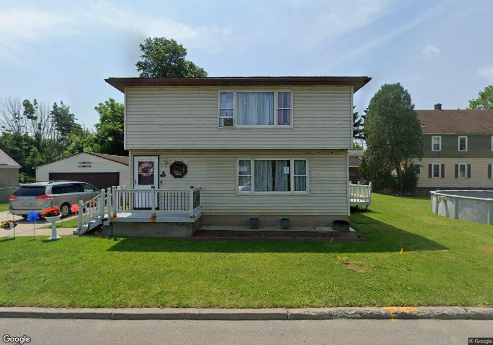
19 Gibbons St Buffalo, NY 14218
Estimated Value: $236,000 - $260,649
6
Beds
2
Baths
2,352
Sq Ft
$105/Sq Ft
Est. Value
About This Home
This home is located at 19 Gibbons St, Buffalo, NY 14218 and is currently estimated at $246,162, approximately $104 per square foot. 19 Gibbons St is a home located in Erie County with nearby schools including Truman Elementary School, Martin Road Elementary School, and Lackawanna Middle School.
Ownership History
Date
Name
Owned For
Owner Type
Purchase Details
Closed on
May 25, 2022
Sold by
Wny Estates Llc
Bought by
Khalique Abdul and Khalique Rabia
Current Estimated Value
Purchase Details
Closed on
Feb 17, 2022
Sold by
Wny Estates Llc
Bought by
Khalique Abdull and Khalique Rabia
Purchase Details
Closed on
Dec 14, 2021
Sold by
Suffoletto Elaine A and Ford Darrell L
Bought by
Wny Estates Llc
Create a Home Valuation Report for This Property
The Home Valuation Report is an in-depth analysis detailing your home's value as well as a comparison with similar homes in the area
Home Values in the Area
Average Home Value in this Area
Purchase History
| Date | Buyer | Sale Price | Title Company |
|---|---|---|---|
| Khalique Abdul | -- | None Available | |
| Khalique Abdul | -- | None Available | |
| Khalique Abdull | $205,000 | Chicago Title Insurance Co | |
| Khalique Abdull | $205,000 | Chicago Title Insurance Co | |
| Wny Estates Llc | $87,500 | None Available | |
| Wny Estates Llc | $87,500 | None Available |
Source: Public Records
Tax History Compared to Growth
Tax History
| Year | Tax Paid | Tax Assessment Tax Assessment Total Assessment is a certain percentage of the fair market value that is determined by local assessors to be the total taxable value of land and additions on the property. | Land | Improvement |
|---|---|---|---|---|
| 2024 | $2,724 | $114,000 | $13,400 | $100,600 |
| 2023 | $2,795 | $114,000 | $13,400 | $100,600 |
| 2022 | $4,819 | $114,000 | $13,400 | $100,600 |
| 2021 | $4,843 | $114,000 | $13,400 | $100,600 |
| 2020 | $1,522 | $114,000 | $13,400 | $100,600 |
| 2019 | $4,372 | $82,000 | $9,500 | $72,500 |
| 2018 | $2,966 | $82,000 | $9,500 | $72,500 |
| 2017 | $1,425 | $82,000 | $9,500 | $72,500 |
| 2016 | $3,182 | $82,000 | $9,500 | $72,500 |
| 2015 | -- | $82,000 | $9,500 | $72,500 |
| 2014 | -- | $82,000 | $9,500 | $72,500 |
Source: Public Records
Map
Nearby Homes
- 1494 Electric Ave
- 1492 Electric Ave
- 310 Center St
- 226 Kirby Ave
- 18-22,128 Maple Grove & Colton Ave Ave
- 18-22 Maple Grove Ave
- 15 Gravel Place
- 109 Victory Ave
- 83 Franklin St
- 11 Michael Place
- 98 Victory Ave
- 55 Spring St
- 2831 S Park Ave
- 63 Knowlton Ave
- 63 Wood St
- 75 Wood St
- 1264 Electric Ave
- 43 Victory Ave
- 2781 S Park Ave
- 21 Victory Ave
- 1510 Electric Ave
- 1512 Electric Ave
- 1488 Electric Ave
- 40 Currant Ave
- 1520 Electric Ave
- 275 Colton Ave
- 283 Colton Ave
- 39 Currant Ave
- 36 Currant Ave
- 263 Colton Ave
- 35 Currant Ave
- 1486 Electric Ave
- 285 Colton Ave
- 34 Currant Ave
- 1526 Electric Ave
- 1526 Electric Ave Unit Upper
- 33 Currant Ave
- 253 Colton Ave
- 291 Colton Ave
- 30 Currant Ave