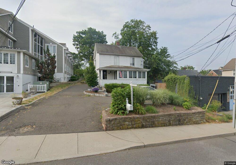
19 Ketchum St Westport, CT 06880
Saugatuck NeighborhoodEstimated Value: $1,159,874
4
Beds
3
Baths
1,950
Sq Ft
$595/Sq Ft
Est. Value
About This Home
This home is located at 19 Ketchum St, Westport, CT 06880 and is currently estimated at $1,159,874, approximately $594 per square foot. 19 Ketchum St is a home located in Fairfield County with nearby schools including King's Highway Elementary School, Coleytown Middle School, and Staples High School.
Ownership History
Date
Name
Owned For
Owner Type
Purchase Details
Closed on
Mar 9, 2007
Sold by
Zaffina Peter M and Zaffina Mary Bethany
Bought by
Romano Peter and Leth Roblyn
Current Estimated Value
Purchase Details
Closed on
Dec 23, 2003
Sold by
Est Bray Paul Jr and Bray Penelope A
Bought by
Zaffina Peter M and Zaffina Mary Bethany
Home Financials for this Owner
Home Financials are based on the most recent Mortgage that was taken out on this home.
Original Mortgage
$318,750
Interest Rate
6.75%
Mortgage Type
Commercial
Create a Home Valuation Report for This Property
The Home Valuation Report is an in-depth analysis detailing your home's value as well as a comparison with similar homes in the area
Home Values in the Area
Average Home Value in this Area
Purchase History
| Date | Buyer | Sale Price | Title Company |
|---|---|---|---|
| Romano Peter | $800,000 | -- | |
| Romano Peter | $800,000 | -- | |
| Zaffina Peter M | $212,500 | -- | |
| Zaffina Peter M | $212,500 | -- | |
| Zaffina Peter M | $212,500 | -- |
Source: Public Records
Mortgage History
| Date | Status | Borrower | Loan Amount |
|---|---|---|---|
| Closed | Zaffina Peter M | $800,000 | |
| Previous Owner | Zaffina Peter M | $114,000 | |
| Previous Owner | Zaffina Peter M | $318,750 |
Source: Public Records
Tax History Compared to Growth
Tax History
| Year | Tax Paid | Tax Assessment Tax Assessment Total Assessment is a certain percentage of the fair market value that is determined by local assessors to be the total taxable value of land and additions on the property. | Land | Improvement |
|---|---|---|---|---|
| 2025 | $6,803 | $360,700 | $222,500 | $138,200 |
| 2024 | $6,716 | $360,700 | $222,500 | $138,200 |
| 2023 | $6,619 | $360,700 | $222,500 | $138,200 |
| 2022 | $6,518 | $360,700 | $222,500 | $138,200 |
| 2021 | $6,518 | $360,700 | $222,500 | $138,200 |
| 2020 | $6,340 | $379,400 | $247,200 | $132,200 |
| 2019 | $6,397 | $379,400 | $247,200 | $132,200 |
| 2018 | $6,397 | $379,400 | $247,200 | $132,200 |
| 2017 | $6,397 | $379,400 | $247,200 | $132,200 |
| 2016 | $6,397 | $379,400 | $247,200 | $132,200 |
| 2015 | $6,570 | $363,200 | $247,200 | $116,000 |
| 2014 | $6,516 | $363,200 | $247,200 | $116,000 |
Source: Public Records
Map
Nearby Homes
- 202 Bradley Ln Unit 202
- 26 Treadwell Ave
- 6 Stony Point Rd
- 23 Bridge St
- 11 Manitou Ct
- 14 Strathmore Ln
- 7 Renzulli Rd
- 110 William St
- 42 Kings Hwy S
- 5 Franklin Ave
- 3 Laurel Ln
- 171 & 169 Compo Rd S
- 171 Compo Rd S
- 13 Hills Ln
- 17 Oriole Dr
- 44 King St
- 115 Valley Rd
- 80 County St Unit 9K
- 80 County St Unit 3A
- 80 County St Unit 2Q
- 31 Franklin St Unit 2NDFL
- 31 Franklin St Unit 1SF F
- 31 Franklin St Unit 2ND
- 31 Franklin St Unit 1
- 35 Franklin St
- 30 Franklin St
- 30 Franklin St Unit 1
- 30 Franklin St Unit 3
- 38 Franklin St
- 38 Franklin St Unit Fl 3
- 34 Franklin St
- 34 Franklin St Unit 2
- 26 Franklin St
- 26 Franklin St Unit 3
- 20 Ketchum St
- 44 Franklin St
- 18 Franklin St Unit 18A
- 18 Franklin St Unit A
- 18 Franklin St Unit B
- 18 Franklin St Unit C