Estimated Value: $101,000 - $134,000
--
Bed
--
Bath
832
Sq Ft
$143/Sq Ft
Est. Value
About This Home
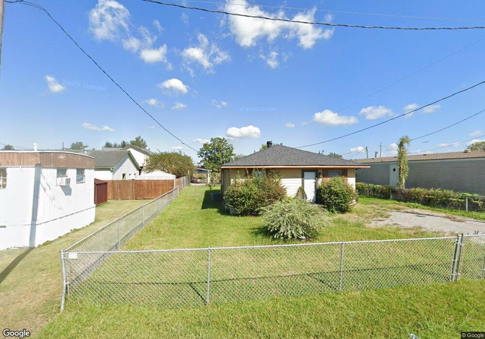
This home is located at 1916 Deborah St, Houma, LA 70360 and is currently estimated at $119,140, approximately $143 per square foot. 1916 Deborah St is a home located in Terrebonne Parish with nearby schools including Lisa Park Elementary School, Houma Junior High School, and Terrebonne High School.
Ownership History
Date
Name
Owned For
Owner Type
Purchase Details
Closed on
Sep 22, 2021
Sold by
Oneal John R
Bought by
Allen Garrett D and Allen Craig D
Current Estimated Value
Purchase Details
Closed on
Jun 19, 2015
Sold by
Nail Shirin Siganporia and Nail Billy Dane
Bought by
Oneal John Ryan
Home Financials for this Owner
Home Financials are based on the most recent Mortgage that was taken out on this home.
Original Mortgage
$97,959
Interest Rate
3.9%
Mortgage Type
New Conventional
Purchase Details
Closed on
Oct 15, 2013
Sold by
Me & Cinderella Llc
Bought by
Nail Shirin Siganporia
Purchase Details
Closed on
Apr 26, 2013
Create a Home Valuation Report for This Property
The Home Valuation Report is an in-depth analysis detailing your home's value as well as a comparison with similar homes in the area
Home Values in the Area
Average Home Value in this Area
Purchase History
| Date | Buyer | Sale Price | Title Company |
|---|---|---|---|
| Allen Garrett D | $101,800 | None Available | |
| Oneal John Ryan | $96,000 | Attorney | |
| Nail Shirin Siganporia | $82,351 | -- | |
| -- | $83,000 | -- |
Source: Public Records
Mortgage History
| Date | Status | Borrower | Loan Amount |
|---|---|---|---|
| Previous Owner | Oneal John Ryan | $97,959 |
Source: Public Records
Tax History Compared to Growth
Tax History
| Year | Tax Paid | Tax Assessment Tax Assessment Total Assessment is a certain percentage of the fair market value that is determined by local assessors to be the total taxable value of land and additions on the property. | Land | Improvement |
|---|---|---|---|---|
| 2024 | $336 | $7,020 | $1,580 | $5,440 |
| 2023 | $336 | $6,680 | $1,500 | $5,180 |
| 2022 | $311 | $6,680 | $1,500 | $5,180 |
| 2021 | $280 | $6,160 | $1,500 | $4,660 |
| 2020 | $575 | $6,680 | $1,500 | $5,180 |
| 2019 | $626 | $6,680 | $1,500 | $5,180 |
| 2018 | $0 | $6,360 | $1,430 | $4,930 |
| 2017 | $611 | $6,360 | $1,430 | $4,930 |
| 2015 | -- | $6,055 | $1,360 | $4,695 |
| 2014 | -- | $6,055 | $0 | $0 |
| 2013 | $569 | $6,055 | $0 | $0 |
Source: Public Records
Map
Nearby Homes
- 179 Enterprise Dr
- 112 Wayne Ave
- 6541 W Park Ave
- 273 Rue Max
- 310 Grace St
- 123 Wayne Ave
- 230 Derusso St
- 320 & 320-A Grace St
- 115 Louis Dr
- 158 Wayne Ave
- 203 Fairmont Dr
- 205 Harding Dr
- 220 Derusso St
- 202 Fairmont Dr
- 226 Derusso St
- 218 Ziegler Ave
- 1794 Martin Luther King jr
- 292 Enterprise Dr
- 207 N French Quarter Dr
- 205 S French Quarter Dr
- 109 Ann Carol St Unit JUDY
- 109 Ann Carol St
- 107 Ann Carol St
- 105 Ann Carol St
- 1921 Deborah St
- 205 Ann Carol St Unit 1
- 205 Ann Carol St
- 122 Enterprise Dr
- 122 Enterprise Dr Unit B
- 114 Enterprise Dr Unit C
- 6650 W Main St
- 6634 W Main St
- 6642 W Main St
- 209 Ann Carol St
- 200 Ann Carol St
- 6656 W Main St
- 110 Ann Carol St
- 211 Ann Carol St
- 213 Ann Carol St
- 6670 W Main St