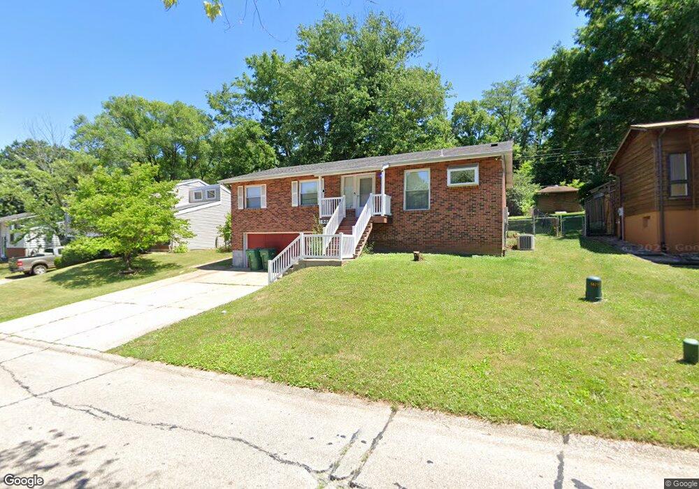
1946 Catlin Dr Barnhart, MO 63012
Estimated Value: $239,374 - $251,000
--
Bed
--
Bath
1,144
Sq Ft
$214/Sq Ft
Est. Value
About This Home
This home is located at 1946 Catlin Dr, Barnhart, MO 63012 and is currently estimated at $244,594, approximately $213 per square foot. 1946 Catlin Dr is a home located in Jefferson County with nearby schools including Windsor High School and St. Joseph Catholic School.
Ownership History
Date
Name
Owned For
Owner Type
Purchase Details
Closed on
Dec 31, 2001
Sold by
Byerly Kimala Ann and Byerly Jerold I
Bought by
Effan Harvey N and Effan Carol A
Current Estimated Value
Home Financials for this Owner
Home Financials are based on the most recent Mortgage that was taken out on this home.
Original Mortgage
$116,350
Outstanding Balance
$46,733
Interest Rate
6.8%
Estimated Equity
$197,861
Create a Home Valuation Report for This Property
The Home Valuation Report is an in-depth analysis detailing your home's value as well as a comparison with similar homes in the area
Home Values in the Area
Average Home Value in this Area
Purchase History
| Date | Buyer | Sale Price | Title Company |
|---|---|---|---|
| Effan Harvey N | -- | Commonwealth Title |
Source: Public Records
Mortgage History
| Date | Status | Borrower | Loan Amount |
|---|---|---|---|
| Open | Effan Harvey N | $116,350 |
Source: Public Records
Tax History Compared to Growth
Tax History
| Year | Tax Paid | Tax Assessment Tax Assessment Total Assessment is a certain percentage of the fair market value that is determined by local assessors to be the total taxable value of land and additions on the property. | Land | Improvement |
|---|---|---|---|---|
| 2025 | $1,619 | $23,500 | $4,800 | $18,700 |
| 2024 | $1,619 | $22,100 | $4,800 | $17,300 |
| 2023 | $1,619 | $22,100 | $4,800 | $17,300 |
| 2022 | $1,434 | $19,600 | $2,300 | $17,300 |
| 2021 | $1,434 | $19,600 | $2,300 | $17,300 |
| 2020 | $1,335 | $17,700 | $1,900 | $15,800 |
| 2019 | $1,333 | $17,700 | $1,900 | $15,800 |
| 2018 | $1,315 | $17,700 | $1,900 | $15,800 |
| 2017 | $1,265 | $17,700 | $1,900 | $15,800 |
| 2016 | $1,155 | $16,100 | $1,900 | $14,200 |
| 2015 | $1,152 | $16,100 | $1,900 | $14,200 |
| 2013 | -- | $15,600 | $1,900 | $13,700 |
Source: Public Records
Map
Nearby Homes
- 7001 Wayles Dr
- 0 Hwy Mm Unit MAR24032005
- 2108 S Oaks Dr
- 2155 Catlin Ct
- 7056 Albermarle Ct
- 7075 Metropolitan Blvd
- 7062 Tuckahoe Ct
- 1675 Old State Road M
- 0 New Highway M Unit MAR25024234
- 6625 Dry Creek Rd
- 6788 Haven Hill Rd
- 7255 Meriwether Ct
- 7098 Ridge Dr
- 0 Highland Terrace
- 7776 Locust Dr
- Rockwood Plan at Springbrook Farms
- Chicory Plan at Springbrook Farms
- Southview Plan at Springbrook Farms
- Jefferson II Plan at Springbrook Farms
- Grantwood Plan at Springbrook Farms
- 1940 Catlin Dr
- 1952 Catlin Dr
- 1934 Catlin Dr
- 1958 Catlin Dr
- 1949 Catlin Dr
- 1943 Catlin Dr
- 1937 Catlin Dr
- 1928 Catlin Dr
- 1964 Catlin Dr
- 1953 Catlin Dr
- 1959 Catlin Dr
- 1922 Catlin Dr
- 1970 Catlin Dr
- 1931 Catlin Dr
- 1965 Catlin Dr
- 1925 Catlin Dr
- 1971 Catlin Dr
- 1976 Catlin Dr
- 1916 Catlin Dr
- 1966 Parkton Way