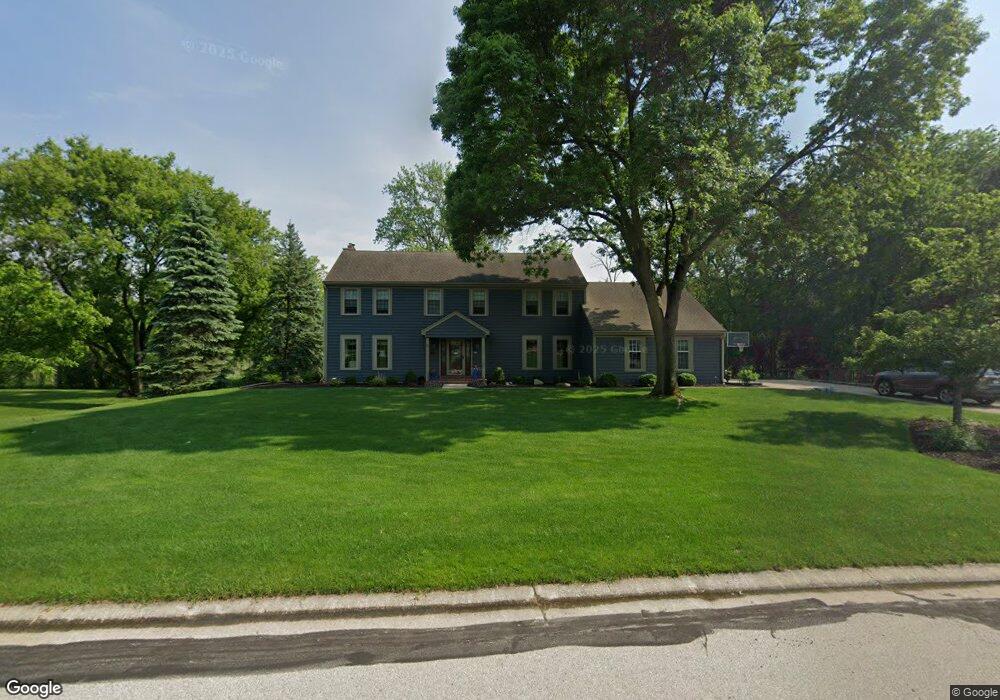
19855 Independence Dr Brookfield, WI 53045
Estimated Value: $639,000 - $746,000
4
Beds
3
Baths
2,880
Sq Ft
$237/Sq Ft
Est. Value
About This Home
This home is located at 19855 Independence Dr, Brookfield, WI 53045 and is currently estimated at $682,170, approximately $236 per square foot. 19855 Independence Dr is a home located in Waukesha County with nearby schools including Brookfield Elementary School, Wisconsin Hills Middle School, and Brookfield Central High School.
Ownership History
Date
Name
Owned For
Owner Type
Purchase Details
Closed on
Aug 7, 1996
Sold by
Fagan Frank J and Fagan Barbara K
Bought by
Nortman William A and Nortman Jane A
Current Estimated Value
Home Financials for this Owner
Home Financials are based on the most recent Mortgage that was taken out on this home.
Original Mortgage
$120,000
Outstanding Balance
$9,461
Interest Rate
8.18%
Mortgage Type
Purchase Money Mortgage
Estimated Equity
$672,709
Create a Home Valuation Report for This Property
The Home Valuation Report is an in-depth analysis detailing your home's value as well as a comparison with similar homes in the area
Home Values in the Area
Average Home Value in this Area
Purchase History
| Date | Buyer | Sale Price | Title Company |
|---|---|---|---|
| Nortman William A | $266,900 | -- |
Source: Public Records
Mortgage History
| Date | Status | Borrower | Loan Amount |
|---|---|---|---|
| Open | Nortman William A | $120,000 |
Source: Public Records
Tax History Compared to Growth
Tax History
| Year | Tax Paid | Tax Assessment Tax Assessment Total Assessment is a certain percentage of the fair market value that is determined by local assessors to be the total taxable value of land and additions on the property. | Land | Improvement |
|---|---|---|---|---|
| 2024 | $6,443 | $573,300 | $148,500 | $424,800 |
| 2023 | $6,450 | $573,300 | $148,500 | $424,800 |
| 2022 | $6,490 | $451,500 | $143,000 | $308,500 |
| 2021 | $6,877 | $451,500 | $143,000 | $308,500 |
| 2020 | $7,161 | $451,500 | $143,000 | $308,500 |
| 2019 | $6,883 | $451,500 | $143,000 | $308,500 |
| 2018 | $7,006 | $446,500 | $140,000 | $306,500 |
| 2017 | $6,997 | $446,500 | $140,000 | $306,500 |
| 2016 | $7,098 | $446,500 | $140,000 | $306,500 |
| 2015 | $7,055 | $446,500 | $140,000 | $306,500 |
| 2014 | $7,068 | $431,600 | $140,000 | $291,600 |
| 2013 | $7,068 | $431,600 | $140,000 | $291,600 |
Source: Public Records
Map
Nearby Homes
- 1375 Barrington Woods Dr
- 20025 Freedom Ct
- 1345 Overlook Cir
- 950 N Barker Rd
- 1660 Constitution Dr
- 890 Janacek Rd
- 19250 Benington Dr
- 19145 Arlyne Ct
- 19775 Trilby Ct
- 1485 N Brookfield Rd
- 18880 Toldt Woods Dr Unit 6
- 18660 Bonnie Ln
- 1135 Greenridge Terrace
- 18415 W Wisconsin Ave Unit 18415
- 18600 Brookfield Lake Dr Unit 53
- 165 Aerie Cir Unit 105
- 165 Aerie Cir Unit 102
- 18575 Brookfield Lake Dr Unit 61
- 18710 Follett Dr Unit 502
- 2423 Kossow Rd
- 19895 Independence Dr
- 19805 Independence Dr
- 19870 Independence Dr
- 1270 Betsy Ross Ct
- 19945 Independence Dr
- 19785 Independence Dr
- 1290 Lexington Ct
- 19985 Independence Dr
- 1290 Betsy Ross Ct
- 19745 Independence Dr
- 1310 Lexington Ct
- 1295 Barrington Woods Dr
- 1325 Lexington Ct
- 1300 Betsy Ross Ct
- 1315 Barrington Woods Dr
- 1330 Lexington Ct
- 19715 Independence Ct
- 20045 Independence Dr
- 1345 Lexington Ct
- 1280 Barrington Woods Dr