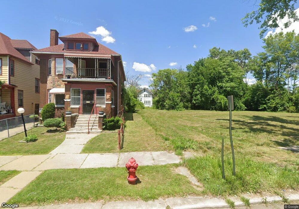
1990 Seward St Detroit, MI 48206
LaSalle Gardens NeighborhoodEstimated Value: $65,780 - $85,000
--
Bed
2
Baths
2,236
Sq Ft
$35/Sq Ft
Est. Value
About This Home
This home is located at 1990 Seward St, Detroit, MI 48206 and is currently estimated at $77,593, approximately $34 per square foot. 1990 Seward St is a home located in Wayne County with nearby schools including Thirkell Elementary School, Charles L. Spain Elementary-Middle School, and Edward 'Duke' Ellington Conservatory of Music and Art.
Ownership History
Date
Name
Owned For
Owner Type
Purchase Details
Closed on
Oct 30, 2014
Sold by
The City Of Detroit
Bought by
The Detroit Land Bank Authority
Current Estimated Value
Purchase Details
Closed on
Jan 19, 2010
Sold by
Wojtowicz Raymond J
Bought by
Planning & Development Dept City Of Detr
Purchase Details
Closed on
Jul 16, 2004
Sold by
Bernice M Harvey Revocable Trust
Bought by
Smith David
Purchase Details
Closed on
Jul 30, 2003
Sold by
Harvey Bernice M
Bought by
Harvey Bernice M and Bernice M Harvey Revocable Trust
Create a Home Valuation Report for This Property
The Home Valuation Report is an in-depth analysis detailing your home's value as well as a comparison with similar homes in the area
Home Values in the Area
Average Home Value in this Area
Purchase History
| Date | Buyer | Sale Price | Title Company |
|---|---|---|---|
| The Detroit Land Bank Authority | -- | Attorney | |
| Planning & Development Dept City Of Detr | -- | None Available | |
| Smith David | $49,500 | Great Lakes Title Of Mi | |
| Harvey Bernice M | -- | -- |
Source: Public Records
Tax History Compared to Growth
Tax History
| Year | Tax Paid | Tax Assessment Tax Assessment Total Assessment is a certain percentage of the fair market value that is determined by local assessors to be the total taxable value of land and additions on the property. | Land | Improvement |
|---|---|---|---|---|
| 2025 | -- | $0 | $0 | $0 |
| 2024 | -- | $0 | $0 | $0 |
| 2023 | $0 | $0 | $0 | $0 |
| 2022 | -- | $0 | $0 | $0 |
| 2021 | $0 | $0 | $0 | $0 |
| 2020 | $2,107 | $0 | $0 | $0 |
| 2019 | $2,107 | $0 | $0 | $0 |
| 2018 | $0 | $0 | $0 | $0 |
| 2017 | -- | $0 | $0 | $0 |
| 2016 | -- | $0 | $0 | $0 |
| 2015 | -- | $0 | $0 | $0 |
| 2013 | $2,107 | $0 | $0 | $0 |
| 2010 | -- | $25,850 | $793 | $25,057 |
Source: Public Records
Map
Nearby Homes
- 1975 Virginia Park St
- 2081 Virginia Park St
- 2091 Seward St
- 7759 Rosa Parks Blvd
- 2237 W Philadelphia St
- 2280 Virginia Park St
- 1923 W Bethune St
- 2270 W Philadelphia St
- 2025 W Euclid St
- 1709 Pallister Unit 28
- 2247 W Philadelphia St
- 2225 W Philadelphia St
- 1703 Pallister Unit P30
- 7534 Churchill St Unit C18
- 7542 Churchill St Unit C21
- 1931 Lamothe St
- 8604 La Salle Blvd
- 7426 Dunedin St
- 7416 Hanover Ave
- 2233 Lamothe St
- 1986 Seward St
- 2006 Seward St
- 1996 Seward St
- 2020 Seward St
- 1962 Seward St
- 1989 Virginia Park St
- 1944 Seward Ave Unit 2
- 2003 Virginia Park St
- 2024 Seward St
- 1954 Seward St
- 2011 Virginia Park St
- 1963 Seward St
- 1963 Seward St Unit Lower
- 1967 Seward Ave Unit Upper
- 1997 Seward St
- 1967 Virginia Park St
- 2034 Seward St
- 1940 Seward Ave Unit 1
- 2015 Seward St
- 2025 Virginia Park St