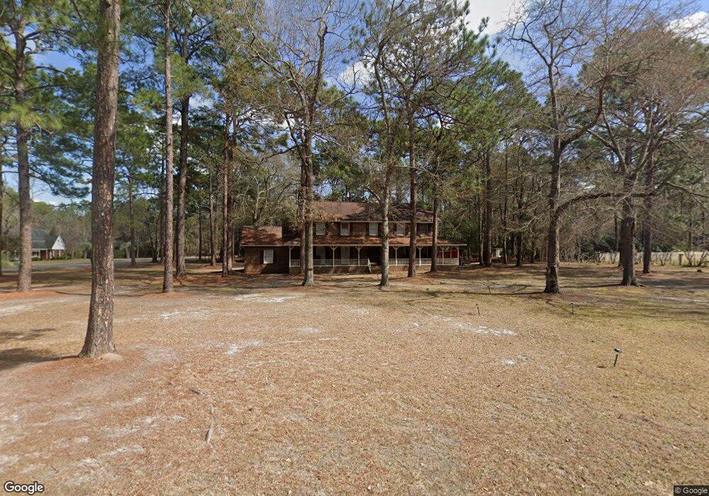
2 Wood Valley Cir Statesboro, GA 30458
Estimated Value: $321,000 - $431,000
4
Beds
3
Baths
2,776
Sq Ft
$133/Sq Ft
Est. Value
About This Home
This home is located at 2 Wood Valley Cir, Statesboro, GA 30458 and is currently estimated at $369,627, approximately $133 per square foot. 2 Wood Valley Cir is a home located in Bulloch County with nearby schools including Statesboro High School, Sallie Zetterower Elementary School, and Langston Chapel Middle School.
Ownership History
Date
Name
Owned For
Owner Type
Purchase Details
Closed on
Dec 30, 2019
Sold by
American Assets Llc
Bought by
Nesmith Michael Trenton
Current Estimated Value
Purchase Details
Closed on
Oct 3, 2005
Sold by
Pruett Robert Edward
Bought by
Nesmith Michael Trenton and Nesmith Matthew S
Home Financials for this Owner
Home Financials are based on the most recent Mortgage that was taken out on this home.
Original Mortgage
$123,959
Interest Rate
5.66%
Mortgage Type
New Conventional
Purchase Details
Closed on
Jul 1, 2002
Bought by
Pruett Robert E
Create a Home Valuation Report for This Property
The Home Valuation Report is an in-depth analysis detailing your home's value as well as a comparison with similar homes in the area
Home Values in the Area
Average Home Value in this Area
Purchase History
| Date | Buyer | Sale Price | Title Company |
|---|---|---|---|
| Nesmith Michael Trenton | -- | -- | |
| Nesmith Michael Trenton | $137,500 | -- | |
| Pruett Robert E | -- | -- |
Source: Public Records
Mortgage History
| Date | Status | Borrower | Loan Amount |
|---|---|---|---|
| Previous Owner | Nesmith Michael Trenton | $123,959 |
Source: Public Records
Tax History Compared to Growth
Tax History
| Year | Tax Paid | Tax Assessment Tax Assessment Total Assessment is a certain percentage of the fair market value that is determined by local assessors to be the total taxable value of land and additions on the property. | Land | Improvement |
|---|---|---|---|---|
| 2024 | $3,612 | $131,800 | $18,000 | $113,800 |
| 2023 | $3,254 | $113,640 | $10,000 | $103,640 |
| 2022 | $1,964 | $100,152 | $10,000 | $90,152 |
| 2021 | $1,684 | $83,480 | $10,000 | $73,480 |
| 2020 | $1,396 | $67,269 | $10,440 | $56,829 |
| 2019 | $1,392 | $66,700 | $10,440 | $56,260 |
| 2018 | $1,381 | $63,437 | $10,440 | $52,997 |
| 2017 | $1,336 | $60,677 | $10,440 | $50,237 |
| 2016 | $1,337 | $59,175 | $10,440 | $48,735 |
| 2015 | $1,294 | $57,040 | $10,440 | $46,600 |
| 2014 | $1,189 | $57,040 | $10,440 | $46,600 |
Source: Public Records
Map
Nearby Homes
- 9 Robin Hood Rd
- 218 S Edgewood Dr
- 204 S Edgewood Dr
- 0 Cawana Rd Unit 10619496
- 1008 Cawana Rd
- 20 Greenwood Ave
- -- Brampton Ave
- 302 Parkersburg Ln
- 0 Lanier Dr Unit 10329553
- Cali Plan at Holly Oaks
- Kerry Plan at Holly Oaks
- Belhaven Plan at Holly Oaks
- Freeport Plan at Holly Oaks
- Manning Plan at Holly Oaks
- Robie Plan at Holly Oaks
- 1508 Oneal Dr
- 1139 Bartlett Dr
- 0 Henry Blvd Unit 10609902
- 503 Saxon Cove
- 0 Stambuk Ln Unit 329856
- 6 Wood Valley Cir
- 1 Wood Valley Cir
- 102 Olde Towne Dr
- 101 Olde Towne Dr
- 103 Olde Towne Dr
- 104 Olde Towne Dr
- 0 Wood Valley Cir
- 0 Wake Forest Ct Unit 8214400
- 8 Wake Forest Ct
- 206 Hawthorne Rd
- 6 Robin Hood Rd
- 218 Wildwood Dr
- 8 Robin Hood Rd
- 107 Olde Towne Dr
- 0 Olde Towne Dr Unit 8001720
- 10 Robin Hood Rd
- 10 Wake Forest Ct
- 106 Olde Towne Dr
- 109 Olde Towne Dr
- 118 Olde Towne Dr