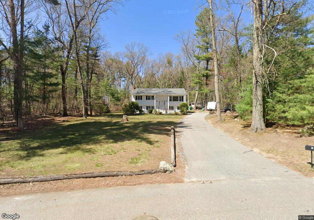
20 David Morris Rd Tewksbury, MA 01876
Estimated Value: $636,000 - $731,000
3
Beds
1
Bath
1,069
Sq Ft
$631/Sq Ft
Est. Value
About This Home
This home is located at 20 David Morris Rd, Tewksbury, MA 01876 and is currently estimated at $674,179, approximately $630 per square foot. 20 David Morris Rd is a home located in Middlesex County with nearby schools including Heath-Brook Elementary School, John W. Wynn Middle School, and John F. Ryan Elementary School.
Ownership History
Date
Name
Owned For
Owner Type
Purchase Details
Closed on
Jan 23, 2020
Sold by
Cunningham Ralph
Bought by
R L Cunnningham Jr Irt
Current Estimated Value
Purchase Details
Closed on
Jan 22, 2020
Sold by
Cunningham Mabel L
Bought by
Mabel L Cunningham Irt
Purchase Details
Closed on
Apr 29, 1976
Bought by
Cunningham Ralph L and Cunningham Mabel L
Create a Home Valuation Report for This Property
The Home Valuation Report is an in-depth analysis detailing your home's value as well as a comparison with similar homes in the area
Home Values in the Area
Average Home Value in this Area
Purchase History
| Date | Buyer | Sale Price | Title Company |
|---|---|---|---|
| R L Cunnningham Jr Irt | -- | None Available | |
| Mabel L Cunningham Irt | -- | None Available | |
| Cunningham Ralph L | $44,300 | -- |
Source: Public Records
Tax History Compared to Growth
Tax History
| Year | Tax Paid | Tax Assessment Tax Assessment Total Assessment is a certain percentage of the fair market value that is determined by local assessors to be the total taxable value of land and additions on the property. | Land | Improvement |
|---|---|---|---|---|
| 2025 | $7,884 | $596,400 | $339,000 | $257,400 |
| 2024 | $7,541 | $563,200 | $323,200 | $240,000 |
| 2023 | $7,405 | $525,200 | $293,800 | $231,400 |
| 2022 | $7,039 | $463,100 | $255,900 | $207,200 |
| 2021 | $6,712 | $427,000 | $232,800 | $194,200 |
| 2020 | $6,584 | $412,300 | $221,900 | $190,400 |
| 2019 | $5,967 | $376,700 | $211,500 | $165,200 |
| 2018 | $3,447 | $359,500 | $211,500 | $148,000 |
| 2017 | $5,593 | $342,900 | $211,500 | $131,400 |
| 2016 | $5,443 | $332,900 | $211,500 | $121,400 |
| 2015 | $5,188 | $316,900 | $201,900 | $115,000 |
| 2014 | $5,099 | $316,500 | $211,500 | $105,000 |
Source: Public Records
Map
Nearby Homes
- 1455 Main St Unit 4
- 1455 Main St Unit 10
- 1455 Main St Unit 8
- 1418 Main St Unit 201
- 1325 Main
- 1334 Main St
- 8 Boisvert Rd
- 11 Orchard St
- 142 Patrick Rd
- 61 Patrick Rd
- 111 Patrick Rd Unit 111
- 6 Stonebury Way Unit 6
- 100 Pleasant St Unit 14
- 100 Pine St
- 13 Berkeley
- 14 Hinckley Rd
- 70 Ronald Dr
- 1042 Chandler St
- 27 Marie St
- 31 Marie St
- 30 David Morris Rd
- 21 David Morris Rd
- 40 David Morris Rd
- 31 David Morris Rd
- 11 David Morris Rd
- 40 Foster Rd
- 30 Foster Rd
- 50 David Morris Rd
- 50 Foster Rd
- 20 Foster Rd
- 41 David Morris Rd
- 10 Foster Rd
- 49 Foster Rd
- 55 Foster Rd
- 51 David Morris Rd
- 538 Chandler St
- 59 Foster Rd
- 518 Chandler St
- 60 Foster Rd
- 25 Foster Rd